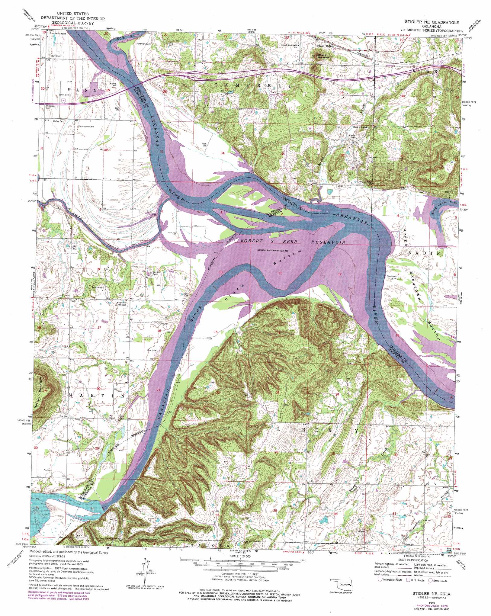
Stigler Ne Topo Map Oklahoma
To zoom in, hover over the map of Stigler Ne
USGS Topo Quad 35095d1 - 1:24,000 scale
| Topo Map Name: | Stigler Ne |
| USGS Topo Quad ID: | 35095d1 |
| Print Size: | ca. 21 1/4" wide x 27" high |
| Southeast Coordinates: | 35.375° N latitude / 95° W longitude |
| Map Center Coordinates: | 35.4375° N latitude / 95.0625° W longitude |
| U.S. State: | OK |
| Filename: | o35095d1.jpg |
| Download Map JPG Image: | Stigler Ne topo map 1:24,000 scale |
| Map Type: | Topographic |
| Topo Series: | 7.5´ |
| Map Scale: | 1:24,000 |
| Source of Map Images: | United States Geological Survey (USGS) |
| Alternate Map Versions: |
Stigler NE OK 1963, updated 1964 Download PDF Buy paper map Stigler NE OK 1963, updated 1975 Download PDF Buy paper map Stigler NE OK 1963, updated 1979 Download PDF Buy paper map Stigler NE OK 1964, updated 1964 Download PDF Buy paper map Stigler NE OK 2010 Download PDF Buy paper map Stigler NE OK 2012 Download PDF Buy paper map Stigler NE OK 2016 Download PDF Buy paper map |
1:24,000 Topo Quads surrounding Stigler Ne
Southeast Muskogee |
Braggs |
Qualls |
Cookson |
Bunch |
Keefton |
Webbers Falls |
Gore |
Blackgum |
Marble City |
Warner |
Holt Mountain |
Stigler Ne |
Vian |
Sallisaw |
Porum |
Stigler West |
Stigler East |
Keota |
Robert S Kerr Dam |
Quinton North |
Sans Bois |
Lafayette |
Mccurtain |
Bokoshe |
> Back to 35095a1 at 1:100,000 scale
> Back to 35094a1 at 1:250,000 scale
> Back to U.S. Topo Maps home
Stigler Ne topo map: Gazetteer
Stigler Ne: Bends
Hisaw Bottom elevation 140m 459′Upper Sandtown Bottom elevation 140m 459′
Stigler Ne: Dams
Oknoname 111032 Dam elevation 209m 685′Stigler Ne: Falls
Webbers Falls (historical) elevation 140m 459′Stigler Ne: Parks
Sequoyah National Wildlife Refuge elevation 143m 469′Stigler Ne: Reservoirs
Oknoname 111032 Reservoir elevation 209m 685′Sally Jones Lake elevation 140m 459′
Stigler Ne: Streams
Brier Creek elevation 140m 459′Canadian River elevation 140m 459′
Dirty Creek elevation 140m 459′
Illinois River elevation 140m 459′
Negro Creek elevation 140m 459′
Stigler Ne: Summits
Harris Mountain elevation 267m 875′Round Mountain elevation 220m 721′
Stigler Ne digital topo map on disk
Buy this Stigler Ne topo map showing relief, roads, GPS coordinates and other geographical features, as a high-resolution digital map file on DVD: