Braggs Topo Map Oklahoma
To zoom in, hover over the map of Braggs
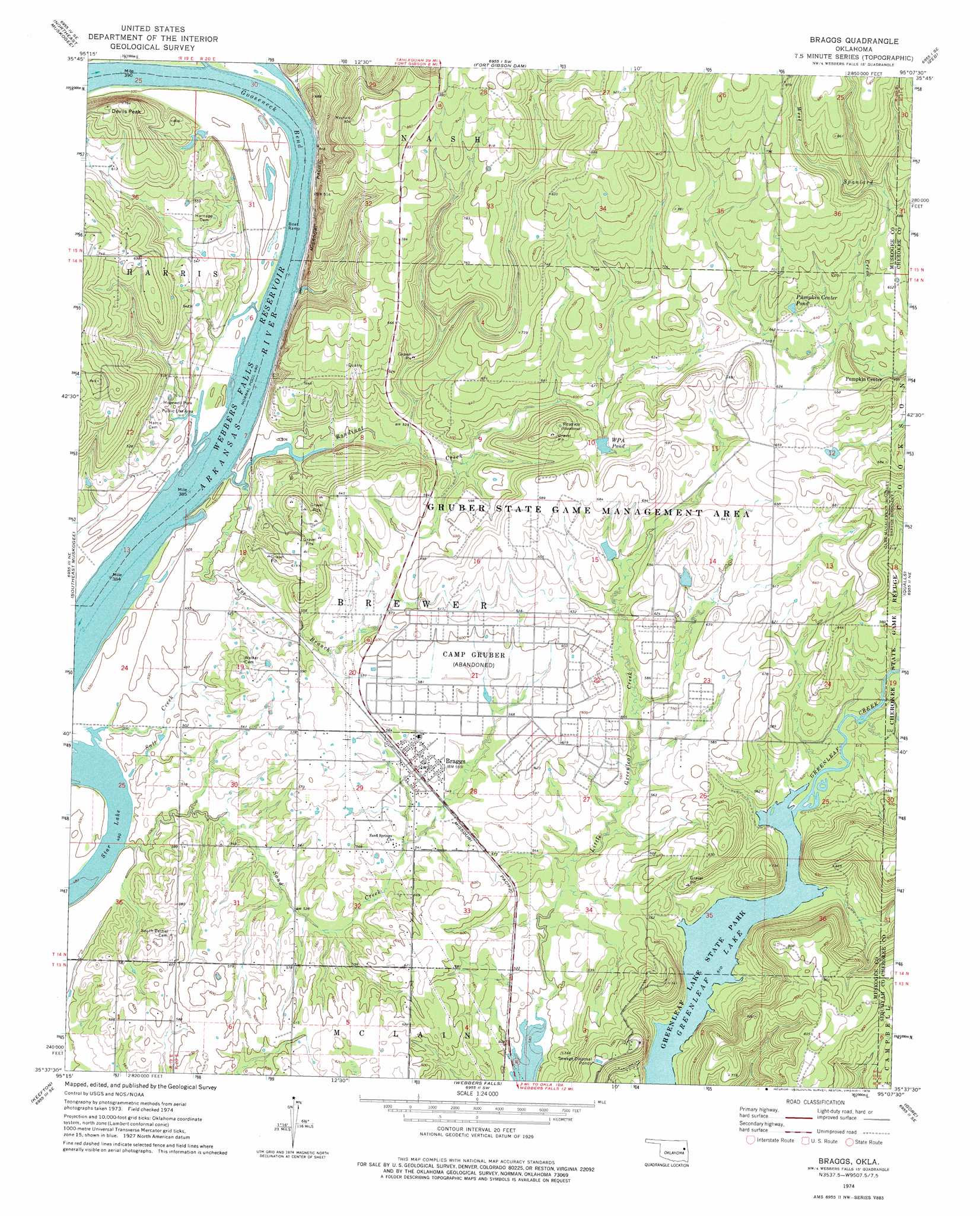
USGS Topo Quad 35095f2 - 1:24,000 scale
| Topo Map Name: | Braggs |
| USGS Topo Quad ID: | 35095f2 |
| Print Size: | ca. 21 1/4" wide x 27" high |
| Southeast Coordinates: | 35.625° N latitude / 95.125° W longitude |
| Map Center Coordinates: | 35.6875° N latitude / 95.1875° W longitude |
| U.S. State: | OK |
| Filename: | o35095f2.jpg |
| Download Map JPG Image: | Braggs topo map 1:24,000 scale |
| Map Type: | Topographic |
| Topo Series: | 7.5´ |
| Map Scale: | 1:24,000 |
| Source of Map Images: | United States Geological Survey (USGS) |
| Alternate Map Versions: |
Webbers Falls NW OK 1974, updated 1974 Download PDF Buy paper map Braggs OK 1974, updated 1978 Download PDF Buy paper map Braggs OK 2010 Download PDF Buy paper map Braggs OK 2012 Download PDF Buy paper map Braggs OK 2016 Download PDF Buy paper map |
1:24,000 Topo Quads surrounding Braggs
Wagoner West |
Wagoner East |
Hulbert |
Thompson Corner |
Tahlequah |
Northwest Muskogee |
Northeast Muskogee |
Fort Gibson Dam |
Zeb |
Park Hill |
Southwest Muskogee |
Southeast Muskogee |
Braggs |
Qualls |
Cookson |
Oktaha |
Keefton |
Webbers Falls |
Gore |
Blackgum |
Warner Nw |
Warner |
Holt Mountain |
Stigler Ne |
Vian |
> Back to 35095e1 at 1:100,000 scale
> Back to 35094a1 at 1:250,000 scale
> Back to U.S. Topo Maps home
Braggs topo map: Gazetteer
Braggs: Airports
Camp Gruber Heliport elevation 173m 567′Braggs: Bends
Gooseneck Bend elevation 149m 488′Braggs: Dams
Little Deep Fork Creek Site 57b Dam elevation 216m 708′Oknoname 101018 Dam elevation 193m 633′
Oknoname 101019 Dam elevation 197m 646′
Oknoname 101020 Dam elevation 184m 603′
Oknoname 101021 Dam elevation 176m 577′
Pumpkin Center Pond Dam elevation 208m 682′
WPA Pond Dam elevation 186m 610′
Braggs: Lakes
Star Lake elevation 149m 488′Braggs: Parks
Gruber State Game Management Area elevation 197m 646′Hopewell Park Public Use Area elevation 153m 501′
Braggs: Populated Places
Braggs elevation 170m 557′Pumpkin Center elevation 182m 597′
Braggs: Reservoirs
Little Deep Fork Creek Site 57b Reservoir elevation 216m 708′Oknoname 101018 Reservoir elevation 193m 633′
Oknoname 101019 Reservoir elevation 197m 646′
Oknoname 101020 Reservoir elevation 184m 603′
Oknoname 101021 Reservoir elevation 176m 577′
Pumpkin Center Pond elevation 199m 652′
W P A Pond elevation 188m 616′
WPA Pond elevation 186m 610′
Braggs: Streams
Bayou Manard elevation 149m 488′Bondinot Creek elevation 149m 488′
Joe Branch elevation 149m 488′
Salt Creek elevation 152m 498′
Sand Creek elevation 150m 492′
Braggs: Summits
Devils Peak elevation 236m 774′Braggs digital topo map on disk
Buy this Braggs topo map showing relief, roads, GPS coordinates and other geographical features, as a high-resolution digital map file on DVD: