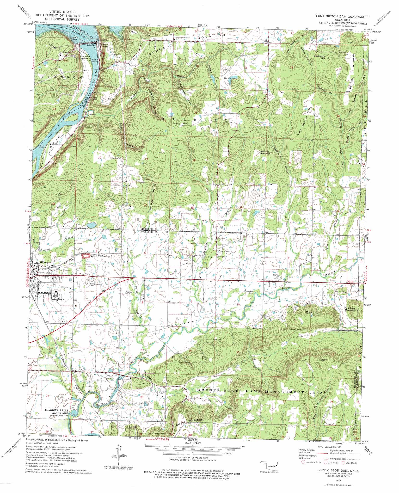
Fort Gibson Dam Topo Map Oklahoma
To zoom in, hover over the map of Fort Gibson Dam
USGS Topo Quad 35095g2 - 1:24,000 scale
| Topo Map Name: | Fort Gibson Dam |
| USGS Topo Quad ID: | 35095g2 |
| Print Size: | ca. 21 1/4" wide x 27" high |
| Southeast Coordinates: | 35.75° N latitude / 95.125° W longitude |
| Map Center Coordinates: | 35.8125° N latitude / 95.1875° W longitude |
| U.S. State: | OK |
| Filename: | o35095g2.jpg |
| Download Map JPG Image: | Fort Gibson Dam topo map 1:24,000 scale |
| Map Type: | Topographic |
| Topo Series: | 7.5´ |
| Map Scale: | 1:24,000 |
| Source of Map Images: | United States Geological Survey (USGS) |
| Alternate Map Versions: |
Hulbert SW OK 1972, updated 1974 Download PDF Buy paper map Fort Gibson Dam OK 1974, updated 1978 Download PDF Buy paper map Fort Gibson Dam OK 2010 Download PDF Buy paper map Fort Gibson Dam OK 2012 Download PDF Buy paper map Fort Gibson Dam OK 2016 Download PDF Buy paper map |
1:24,000 Topo Quads surrounding Fort Gibson Dam
Neodesha |
Rocky Point |
Cedar Crest |
Peggs |
Moodys |
Wagoner West |
Wagoner East |
Hulbert |
Thompson Corner |
Tahlequah |
Northwest Muskogee |
Northeast Muskogee |
Fort Gibson Dam |
Zeb |
Park Hill |
Southwest Muskogee |
Southeast Muskogee |
Braggs |
Qualls |
Cookson |
Oktaha |
Keefton |
Webbers Falls |
Gore |
Blackgum |
> Back to 35095e1 at 1:100,000 scale
> Back to 35094a1 at 1:250,000 scale
> Back to U.S. Topo Maps home
Fort Gibson Dam topo map: Gazetteer
Fort Gibson Dam: Dams
Fort Gibson Dam elevation 152m 498′Fort Gibson Dam: Flats
Lucy Albirdie Flat elevation 270m 885′Fort Gibson Dam: Parks
Canyon Road Public Use Area elevation 155m 508′Dam Site Public Use Area elevation 154m 505′
Fort Gibson Dam: Reservoirs
Fort Gibson Lake elevation 152m 498′Fort Gibson Dam: Streams
Flower Creek elevation 151m 495′Fourmile Branch elevation 156m 511′
Fourteenmile Creek elevation 169m 554′
Hicks Branch elevation 167m 547′
Walker Branch elevation 152m 498′
Fort Gibson Dam: Summits
Blackberry Hill elevation 276m 905′Braggs Mountain elevation 281m 921′
Runnels Mountain elevation 289m 948′
Spurlop Mountain elevation 276m 905′
Fort Gibson Dam: Valleys
Boughtman Hollow elevation 205m 672′Buzzard Hollow elevation 225m 738′
Cedar Hollow elevation 229m 751′
Deadman Hollow elevation 176m 577′
Dripping Spring Hollow elevation 202m 662′
Iron Spring Hollow elevation 213m 698′
Kale Dick Hollow elevation 177m 580′
Limestone Hollow elevation 177m 580′
McGee Hollow elevation 230m 754′
Sleeper Hollow elevation 154m 505′
Sugar Hollow elevation 159m 521′
Whiskey Hollow elevation 181m 593′
Fort Gibson Dam digital topo map on disk
Buy this Fort Gibson Dam topo map showing relief, roads, GPS coordinates and other geographical features, as a high-resolution digital map file on DVD: