Saint Louis Topo Map Oklahoma
To zoom in, hover over the map of Saint Louis
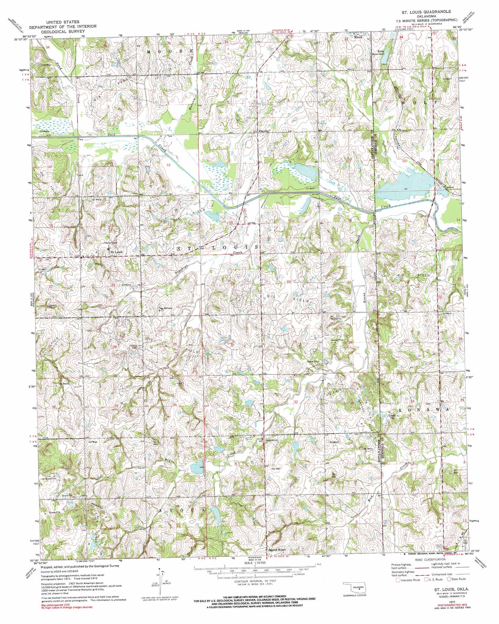
USGS Topo Quad 35096a7 - 1:24,000 scale
| Topo Map Name: | Saint Louis |
| USGS Topo Quad ID: | 35096a7 |
| Print Size: | ca. 21 1/4" wide x 27" high |
| Southeast Coordinates: | 35° N latitude / 96.75° W longitude |
| Map Center Coordinates: | 35.0625° N latitude / 96.8125° W longitude |
| U.S. State: | OK |
| Filename: | o35096a7.jpg |
| Download Map JPG Image: | Saint Louis topo map 1:24,000 scale |
| Map Type: | Topographic |
| Topo Series: | 7.5´ |
| Map Scale: | 1:24,000 |
| Source of Map Images: | United States Geological Survey (USGS) |
| Alternate Map Versions: |
St. Louis OK 1972, updated 1974 Download PDF Buy paper map St. Louis OK 1972, updated 1991 Download PDF Buy paper map Saint Louis OK 2009 Download PDF Buy paper map Saint Louis OK 2012 Download PDF Buy paper map Saint Louis OK 2016 Download PDF Buy paper map |
1:24,000 Topo Quads surrounding Saint Louis
Shawnee Reservoir |
Shawnee |
Earlsboro |
Prague Sw |
Prague Se |
Macomb |
Brooksville |
Maud |
Seminole |
Wewoka West |
Tribbey |
Pearson |
Saint Louis |
Wolf |
Tate Mountain |
Wanette |
Asher |
Konawa |
Vamoosa |
Sasakwa |
Byars |
Stratford |
Vanoss |
Ada |
Francis |
> Back to 35096a1 at 1:100,000 scale
> Back to 35096a1 at 1:250,000 scale
> Back to U.S. Topo Maps home
Saint Louis topo map: Gazetteer
Saint Louis: Dams
Katy Reservoir Dam elevation 271m 889′Salt Creek Site 37 Dam elevation 281m 921′
Salt Creek Site 38 Dam elevation 284m 931′
Salt Creek Site 39 Dam elevation 290m 951′
Salt Creek Site 40 Dam elevation 290m 951′
Salt Creek Site 41 Dam elevation 281m 921′
Saint Louis: Populated Places
Ellaville elevation 277m 908′Sacred Heart elevation 324m 1062′
Saint Louis elevation 312m 1023′
Saint Louis: Reservoirs
Katy Reservoir elevation 275m 902′Salt Creek Site 37 Reservoir elevation 281m 921′
Salt Creek Site 38 Reservoir elevation 284m 931′
Salt Creek Site 39 Reservoir elevation 290m 951′
Salt Creek Site 40 Reservoir elevation 290m 951′
Salt Creek Site 41 Reservoir elevation 281m 921′
Saint Louis: Streams
Bruno Creek elevation 255m 836′Marcum Creek elevation 259m 849′
Popshego Creek elevation 259m 849′
Sand Creek elevation 265m 869′
Saint Louis digital topo map on disk
Buy this Saint Louis topo map showing relief, roads, GPS coordinates and other geographical features, as a high-resolution digital map file on DVD: