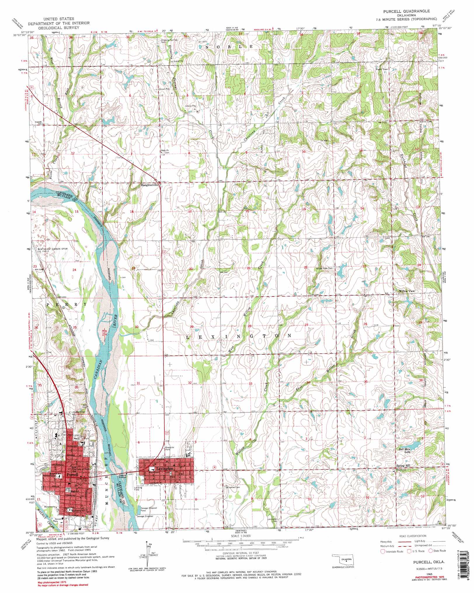
Purcell Topo Map Oklahoma
To zoom in, hover over the map of Purcell
USGS Topo Quad 35097a3 - 1:24,000 scale
| Topo Map Name: | Purcell |
| USGS Topo Quad ID: | 35097a3 |
| Print Size: | ca. 21 1/4" wide x 27" high |
| Southeast Coordinates: | 35° N latitude / 97.25° W longitude |
| Map Center Coordinates: | 35.0625° N latitude / 97.3125° W longitude |
| U.S. State: | OK |
| Filename: | o35097a3.jpg |
| Download Map JPG Image: | Purcell topo map 1:24,000 scale |
| Map Type: | Topographic |
| Topo Series: | 7.5´ |
| Map Scale: | 1:24,000 |
| Source of Map Images: | United States Geological Survey (USGS) |
| Alternate Map Versions: |
Purcell OK 1965, updated 1966 Download PDF Buy paper map Purcell OK 1965, updated 1981 Download PDF Buy paper map Purcell OK 2010 Download PDF Buy paper map Purcell OK 2012 Download PDF Buy paper map Purcell OK 2016 Download PDF Buy paper map |
1:24,000 Topo Quads surrounding Purcell
Oklahoma City Se |
Moore |
Franklin |
Stella |
Shawnee Reservoir |
Newcastle |
Norman |
Denver |
Little Axe |
Macomb |
Cole |
Washington |
Purcell |
Eason |
Tribbey |
Criner |
Stealy |
Wayne |
Rosedale |
Wanette |
Lindsay |
Maysville |
Paoli |
Byars Sw |
Byars |
> Back to 35097a1 at 1:100,000 scale
> Back to 35096a1 at 1:250,000 scale
> Back to U.S. Topo Maps home
Purcell topo map: Gazetteer
Purcell: Airports
McCaslin Airport elevation 345m 1131′Purcell: Dams
Al Salyer Dam elevation 324m 1062′Bell Mere Dam elevation 330m 1082′
Oknoname 02704 Dam elevation 336m 1102′
Oknoname 02705 Dam elevation 337m 1105′
Oknoname 02706 Dam elevation 333m 1092′
Oknoname 02707 Dam elevation 344m 1128′
Oknoname 027070 Dam elevation 330m 1082′
Oknoname 027071 Dam elevation 337m 1105′
Purcell: Oilfields
Alamo Oil Field elevation 339m 1112′Northeast Gibbon Spur Oil Field elevation 322m 1056′
Purcell: Populated Places
Lexington elevation 315m 1033′Purcell elevation 335m 1099′
Slaughterville elevation 341m 1118′
Spring Hill elevation 339m 1112′
Willow View elevation 352m 1154′
Purcell: Reservoirs
Al Salyer Reservoir elevation 324m 1062′Bell Mere Lake elevation 333m 1092′
Oknoname 02704 Reservoir elevation 336m 1102′
Oknoname 02705 Reservoir elevation 337m 1105′
Oknoname 02706 Reservoir elevation 333m 1092′
Oknoname 02707 Reservoir elevation 344m 1128′
Oknoname 027070 Reservoir elevation 330m 1082′
Oknoname 027071 Reservoir elevation 337m 1105′
Purcell: Streams
Boone Creek elevation 319m 1046′Chouteau Creek elevation 314m 1030′
Dripping Springs Creek elevation 329m 1079′
East Branch Boone Creek elevation 325m 1066′
East Willow Creek elevation 321m 1053′
West Branch Boone Creek elevation 325m 1066′
West Willow Creek elevation 318m 1043′
Purcell digital topo map on disk
Buy this Purcell topo map showing relief, roads, GPS coordinates and other geographical features, as a high-resolution digital map file on DVD: