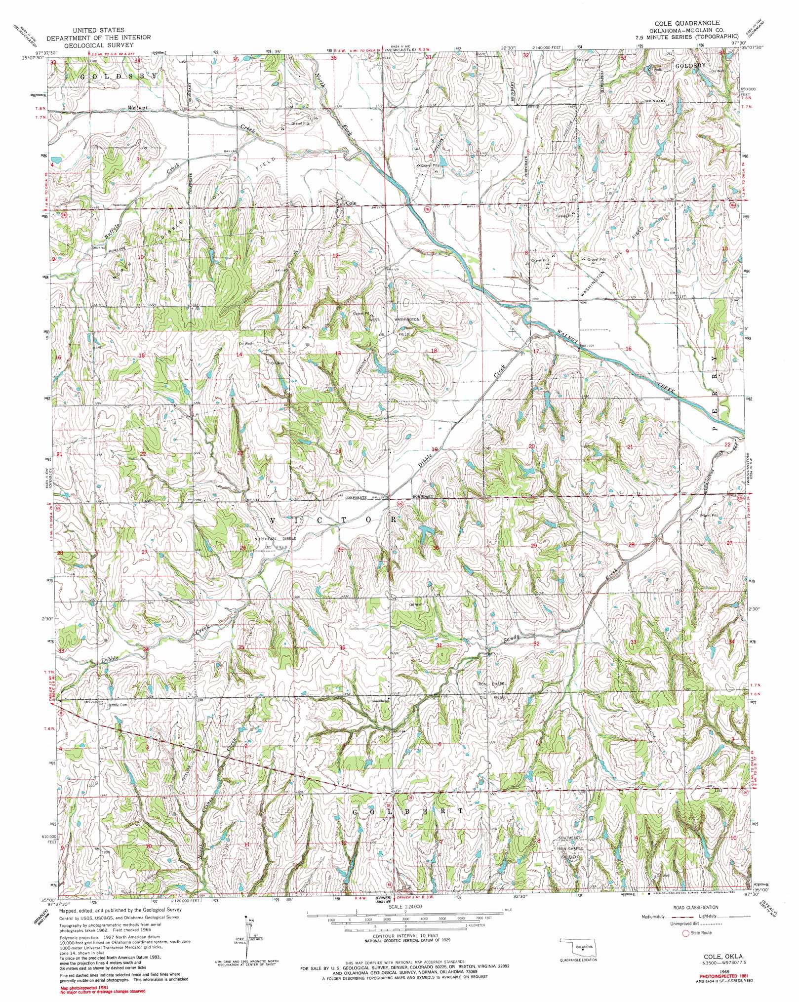
Cole Topo Map Oklahoma
To zoom in, hover over the map of Cole
USGS Topo Quad 35097a5 - 1:24,000 scale
| Topo Map Name: | Cole |
| USGS Topo Quad ID: | 35097a5 |
| Print Size: | ca. 21 1/4" wide x 27" high |
| Southeast Coordinates: | 35° N latitude / 97.5° W longitude |
| Map Center Coordinates: | 35.0625° N latitude / 97.5625° W longitude |
| U.S. State: | OK |
| Filename: | o35097a5.jpg |
| Download Map JPG Image: | Cole topo map 1:24,000 scale |
| Map Type: | Topographic |
| Topo Series: | 7.5´ |
| Map Scale: | 1:24,000 |
| Source of Map Images: | United States Geological Survey (USGS) |
| Alternate Map Versions: |
Cole OK 1965, updated 1966 Download PDF Buy paper map Cole OK 1965, updated 1984 Download PDF Buy paper map Cole OK 2009 Download PDF Buy paper map Cole OK 2013 Download PDF Buy paper map Cole OK 2016 Download PDF Buy paper map |
1:24,000 Topo Quads surrounding Cole
Tuttle |
Oklahoma City Sw |
Oklahoma City Se |
Moore |
Franklin |
Chickasha Ne |
Blanchard |
Newcastle |
Norman |
Denver |
Tabler |
Dibble |
Cole |
Washington |
Purcell |
Alex |
Bradley |
Criner |
Stealy |
Wayne |
East Roaring Creek |
Lindsay Sw |
Lindsay |
Maysville |
Paoli |
> Back to 35097a1 at 1:100,000 scale
> Back to 35096a1 at 1:250,000 scale
> Back to U.S. Topo Maps home
Cole topo map: Gazetteer
Cole: Airports
Flying A Ranch Airport elevation 352m 1154′Paradise Air Haven Airport elevation 366m 1200′
Cole: Dams
Ken Dannels Dam elevation 361m 1184′Oklahoma School Land Comm. Dam elevation 357m 1171′
Oknoname 087004 Dam elevation 364m 1194′
Oknoname 087029 Dam elevation 350m 1148′
Oknoname 087035 Dam elevation 355m 1164′
Cole: Oilfields
Iron Chapel Oil Field elevation 370m 1213′North Dibble Oil Field elevation 362m 1187′
Northeast Dibble Oil Field elevation 345m 1131′
Southeast Iron Chapel Oil Field elevation 372m 1220′
Washington Oil Field elevation 339m 1112′
West Washington Oil Field elevation 369m 1210′
Cole: Populated Places
Cole elevation 349m 1145′Cole: Reservoirs
Ken Dannels Reservoir elevation 361m 1184′Oklahoma School Land Comm. Reservoir elevation 357m 1171′
Oknoname 087004 Reservoir elevation 364m 1194′
Oknoname 087029 Reservoir elevation 350m 1148′
Oknoname 087035 Reservoir elevation 355m 1164′
Cole: Streams
Buffalo Creek elevation 339m 1112′Dibble Creek elevation 330m 1082′
North Fork Walnut Creek elevation 337m 1105′
Cole digital topo map on disk
Buy this Cole topo map showing relief, roads, GPS coordinates and other geographical features, as a high-resolution digital map file on DVD: