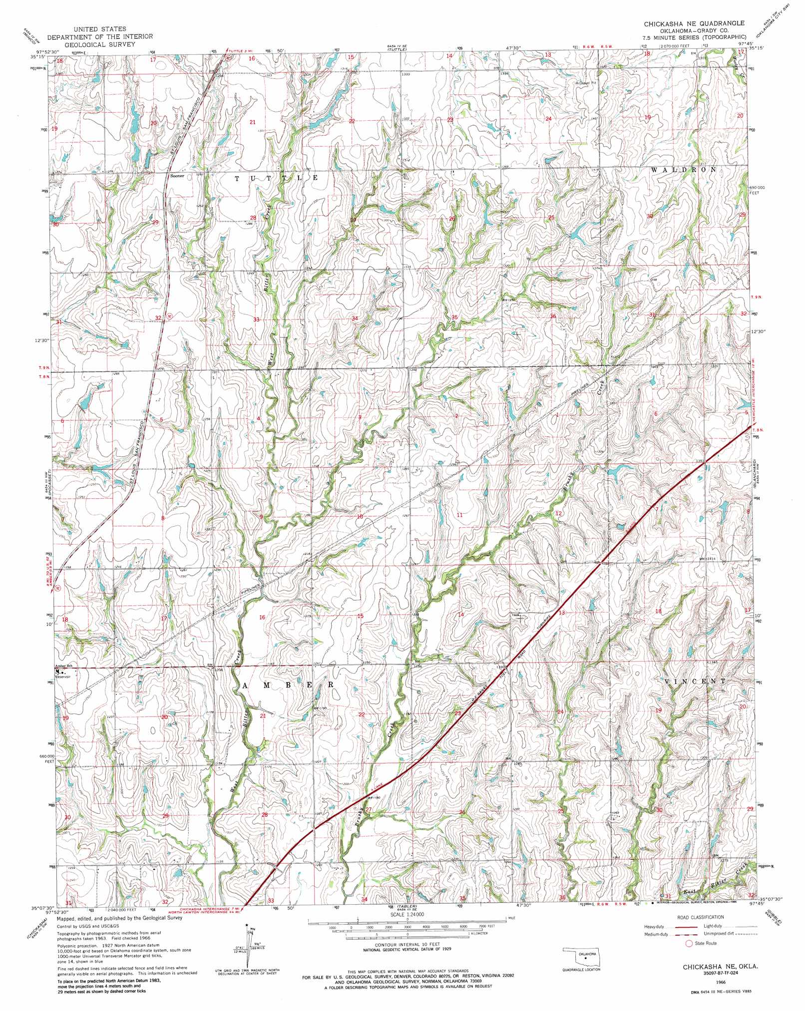
Chickasha Ne Topo Map Oklahoma
To zoom in, hover over the map of Chickasha Ne
USGS Topo Quad 35097b7 - 1:24,000 scale
| Topo Map Name: | Chickasha Ne |
| USGS Topo Quad ID: | 35097b7 |
| Print Size: | ca. 21 1/4" wide x 27" high |
| Southeast Coordinates: | 35.125° N latitude / 97.75° W longitude |
| Map Center Coordinates: | 35.1875° N latitude / 97.8125° W longitude |
| U.S. State: | OK |
| Filename: | o35097b7.jpg |
| Download Map JPG Image: | Chickasha Ne topo map 1:24,000 scale |
| Map Type: | Topographic |
| Topo Series: | 7.5´ |
| Map Scale: | 1:24,000 |
| Source of Map Images: | United States Geological Survey (USGS) |
| Alternate Map Versions: |
Chickasha NE OK 1966, updated 1967 Download PDF Buy paper map Chickasha NE OK 1966, updated 1986 Download PDF Buy paper map Chickasha NE OK 2009 Download PDF Buy paper map Chickasha NE OK 2012 Download PDF Buy paper map Chickasha NE OK 2016 Download PDF Buy paper map |
1:24,000 Topo Quads surrounding Chickasha Ne
Cogar Ne |
Union City |
Minco Ne |
Mustang |
Oklahoma City |
Cogar Se |
Minco |
Tuttle |
Oklahoma City Sw |
Oklahoma City Se |
Anadarko Ne |
Pocasset |
Chickasha Ne |
Blanchard |
Newcastle |
Verden |
Chickasha |
Tabler |
Dibble |
Cole |
Laverty |
East Ninnekah |
Alex |
Bradley |
Criner |
> Back to 35097a1 at 1:100,000 scale
> Back to 35096a1 at 1:250,000 scale
> Back to U.S. Topo Maps home
Chickasha Ne topo map: Gazetteer
Chickasha Ne: Airports
Martin Farms Airport elevation 373m 1223′Chickasha Ne: Dams
Bitter Creek Site 10 Dam elevation 386m 1266′Bitter Creek Site 11 Dam elevation 385m 1263′
Bitter Creek Site 12 Dam elevation 367m 1204′
Bitter Creek Site 2 Dam elevation 353m 1158′
Bitter Creek Site 3 Dam elevation 351m 1151′
Bitter Creek Site 4 Dam elevation 358m 1174′
Bitter Creek Site 6 Dam elevation 382m 1253′
Bitter Creek Site 7 Dam elevation 376m 1233′
Bitter Creek Site 8b Dam elevation 390m 1279′
Bitter Creek Site 9 Dam elevation 357m 1171′
Oknoname 051004 Dam elevation 353m 1158′
Oknoname 051009 Dam elevation 385m 1263′
Oknoname 051010 Dam elevation 382m 1253′
Oknoname 051011 Dam elevation 362m 1187′
Oknoname 051012 Dam elevation 372m 1220′
Oknoname 051039 Dam elevation 423m 1387′
Oknoname 051042 Dam elevation 375m 1230′
Oknoname 051043 Dam elevation 388m 1272′
Oknoname 051044 Dam elevation 384m 1259′
Oknoname 051045 Dam elevation 389m 1276′
Oknoname 051046 Dam elevation 391m 1282′
Chickasha Ne: Populated Places
Sooner elevation 393m 1289′Chickasha Ne: Reservoirs
Bitter Creek Site 10 Reservoir elevation 386m 1266′Bitter Creek Site 11 Reservoir elevation 385m 1263′
Bitter Creek Site 12 Reservoir elevation 367m 1204′
Bitter Creek Site 2 Reservoir elevation 353m 1158′
Bitter Creek Site 3 Reservoir elevation 351m 1151′
Bitter Creek Site 4 Reservoir elevation 358m 1174′
Bitter Creek Site 6 Reservoir elevation 382m 1253′
Bitter Creek Site 7 Reservoir elevation 376m 1233′
Bitter Creek Site 8b Reservoir elevation 390m 1279′
Bityter Creek Site 9 Reservoir elevation 357m 1171′
Oknoname 051004 Reservoir elevation 353m 1158′
Oknoname 051009 Reservoir elevation 385m 1263′
Oknoname 051010 Reservoir elevation 382m 1253′
Oknoname 051011 Reservoir elevation 362m 1187′
Oknoname 051012 Reservoir elevation 372m 1220′
Oknoname 051039 Reservoir elevation 423m 1387′
Oknoname 051042 Reservoir elevation 375m 1230′
Oknoname 051043 Reservoir elevation 388m 1272′
Oknoname 051044 Reservoir elevation 384m 1259′
Oknoname 051045 Reservoir elevation 389m 1276′
Oknoname 051046 Reservoir elevation 391m 1282′
Chickasha Ne digital topo map on disk
Buy this Chickasha Ne topo map showing relief, roads, GPS coordinates and other geographical features, as a high-resolution digital map file on DVD: