Spencer Topo Map Oklahoma
To zoom in, hover over the map of Spencer
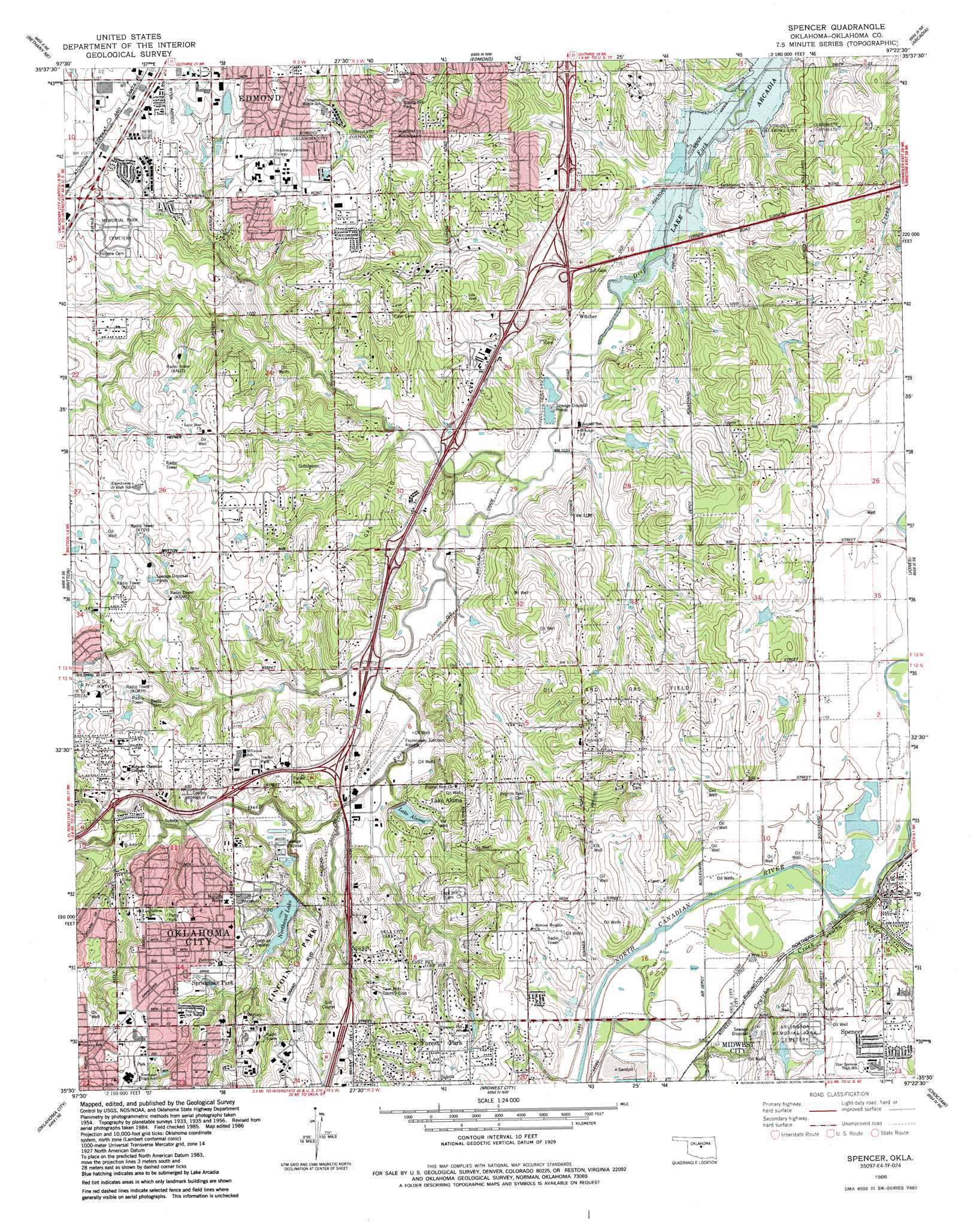
USGS Topo Quad 35097e4 - 1:24,000 scale
| Topo Map Name: | Spencer |
| USGS Topo Quad ID: | 35097e4 |
| Print Size: | ca. 21 1/4" wide x 27" high |
| Southeast Coordinates: | 35.5° N latitude / 97.375° W longitude |
| Map Center Coordinates: | 35.5625° N latitude / 97.4375° W longitude |
| U.S. State: | OK |
| Filename: | o35097e4.jpg |
| Download Map JPG Image: | Spencer topo map 1:24,000 scale |
| Map Type: | Topographic |
| Topo Series: | 7.5´ |
| Map Scale: | 1:24,000 |
| Source of Map Images: | United States Geological Survey (USGS) |
| Alternate Map Versions: |
Spencer OK 1956, updated 1957 Download PDF Buy paper map Spencer OK 1956, updated 1970 Download PDF Buy paper map Spencer OK 1956, updated 1976 Download PDF Buy paper map Spencer OK 1986, updated 1986 Download PDF Buy paper map Spencer OK 1995, updated 1999 Download PDF Buy paper map Spencer OK 2010 Download PDF Buy paper map Spencer OK 2012 Download PDF Buy paper map Spencer OK 2016 Download PDF Buy paper map |
1:24,000 Topo Quads surrounding Spencer
Cashion |
Navina |
Guthrie South |
Guthrie Se |
Meridian |
Piedmont |
Bethany Ne |
Edmond |
Arcadia |
Luther |
Bethany |
Britton |
Spencer |
Jones |
Horseshoe Lake |
Mustang |
Oklahoma City |
Midwest City |
Choctaw |
Harrah |
Oklahoma City Sw |
Oklahoma City Se |
Moore |
Franklin |
Stella |
> Back to 35097e1 at 1:100,000 scale
> Back to 35096a1 at 1:250,000 scale
> Back to U.S. Topo Maps home
Spencer topo map: Gazetteer
Spencer: Airports
5 Alive Heliport elevation 354m 1161′Expressway Airpark elevation 325m 1066′
KWTV Heliport elevation 356m 1167′
Oklahoma National Guard Heliport elevation 366m 1200′
Wynn Airport elevation 356m 1167′
Spencer: Crossings
Interchange 128B elevation 335m 1099′Interchange 129 elevation 342m 1122′
Interchange 130 elevation 345m 1131′
Interchange 130 elevation 358m 1174′
Interchange 132A elevation 336m 1102′
Interchange 134 elevation 323m 1059′
Interchange 135 elevation 326m 1069′
Interchange 136 elevation 320m 1049′
Interchange 137 elevation 328m 1076′
Interchange 138A elevation 322m 1056′
Interchange 138B elevation 336m 1102′
Interchange 139 elevation 332m 1089′
Spencer: Dams
Aluma Dam elevation 331m 1085′Masseys Dam elevation 326m 1069′
Northeast Dam elevation 329m 1079′
Oknoname 9 Dam elevation 308m 1010′
Spencer: Parks
Lincoln Park elevation 347m 1138′Perry Park elevation 347m 1138′
Spring Hill Park elevation 338m 1108′
Springlake Park elevation 339m 1112′
Spencer: Populated Places
Forest Park elevation 370m 1213′Lake Aluma elevation 348m 1141′
Spencer elevation 366m 1200′
Witcher elevation 311m 1020′
Spencer: Reservoirs
Lake Aluma elevation 330m 1082′Masseys Lake elevation 326m 1069′
Northeast Lake elevation 336m 1102′
Oknoname 9 Reservoir elevation 308m 1010′
Spencer: Streams
Crutcho Creek elevation 345m 1131′Silver Creek elevation 345m 1131′
Spencer digital topo map on disk
Buy this Spencer topo map showing relief, roads, GPS coordinates and other geographical features, as a high-resolution digital map file on DVD: