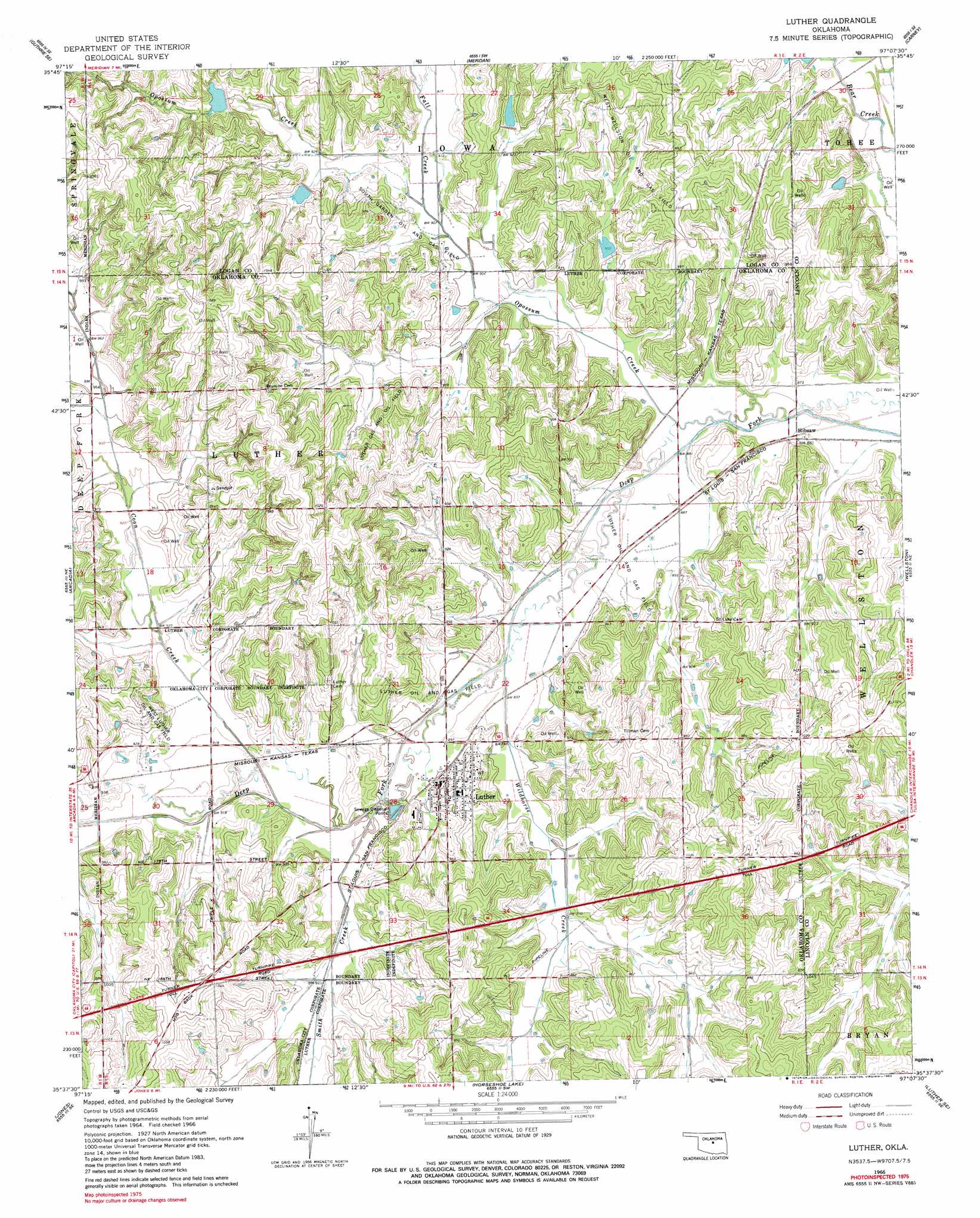
Luther Topo Map Oklahoma
To zoom in, hover over the map of Luther
USGS Topo Quad 35097f2 - 1:24,000 scale
| Topo Map Name: | Luther |
| USGS Topo Quad ID: | 35097f2 |
| Print Size: | ca. 21 1/4" wide x 27" high |
| Southeast Coordinates: | 35.625° N latitude / 97.125° W longitude |
| Map Center Coordinates: | 35.6875° N latitude / 97.1875° W longitude |
| U.S. State: | OK |
| Filename: | o35097f2.jpg |
| Download Map JPG Image: | Luther topo map 1:24,000 scale |
| Map Type: | Topographic |
| Topo Series: | 7.5´ |
| Map Scale: | 1:24,000 |
| Source of Map Images: | United States Geological Survey (USGS) |
| Alternate Map Versions: |
Luther OK 1966, updated 1967 Download PDF Buy paper map Luther OK 1966, updated 1983 Download PDF Buy paper map Luther OK 2010 Download PDF Buy paper map Luther OK 2012 Download PDF Buy paper map Luther OK 2016 Download PDF Buy paper map |
1:24,000 Topo Quads surrounding Luther
Guthrie North |
Langston |
Coyle |
Perkins |
Tryon North |
Guthrie South |
Guthrie Se |
Meridian |
Carney |
Tryon South |
Edmond |
Arcadia |
Luther |
Wellston |
Chandler |
Spencer |
Jones |
Horseshoe Lake |
Luther Se |
Meeker |
Midwest City |
Choctaw |
Harrah |
Mcloud |
Aydelotte |
> Back to 35097e1 at 1:100,000 scale
> Back to 35096a1 at 1:250,000 scale
> Back to U.S. Topo Maps home
Luther topo map: Gazetteer
Luther: Airports
Bost Ranch Airport elevation 325m 1066′Stamper Ranch Airport elevation 311m 1020′
Luther: Dams
Bear Fall Coon Creek Site 20 Dam elevation 275m 902′Bear Fall Coon Creek Site 21 Dam elevation 283m 928′
Bear Fall Coon Creek Site 26 Dam elevation 290m 951′
Bear Fall Coon Creek Site 27 Dam elevation 288m 944′
Oknoname 15 Dam elevation 290m 951′
Luther: Oilfields
Luther Gas and Oil Field elevation 286m 938′South Garden Oil and Gas Field elevation 278m 912′
West Luther Oil and Gas Field elevation 295m 967′
West Wellston Oil and Gas Field elevation 285m 935′
Luther: Populated Places
Hibsaw elevation 266m 872′Luther elevation 279m 915′
Luther: Reservoirs
Bear Fall Coon Creek Site 20 Reservoir elevation 275m 902′Bear Fall Coon Creek Site 21 Reservoir elevation 283m 928′
Bear Fall Coon Creek Site 26 Reservoir elevation 290m 951′
Bear Fall Coon Creek Site 27 Reservoir elevation 288m 944′
Oknoname 15 Reservoir elevation 290m 951′
Luther: Streams
Coon Creek elevation 272m 892′Fall Creek elevation 275m 902′
Opossum Creek elevation 265m 869′
Opossum Creek elevation 265m 869′
Smith Creek elevation 270m 885′
Wildhorse Creek elevation 271m 889′
Luther digital topo map on disk
Buy this Luther topo map showing relief, roads, GPS coordinates and other geographical features, as a high-resolution digital map file on DVD: