Navina Topo Map Oklahoma
To zoom in, hover over the map of Navina
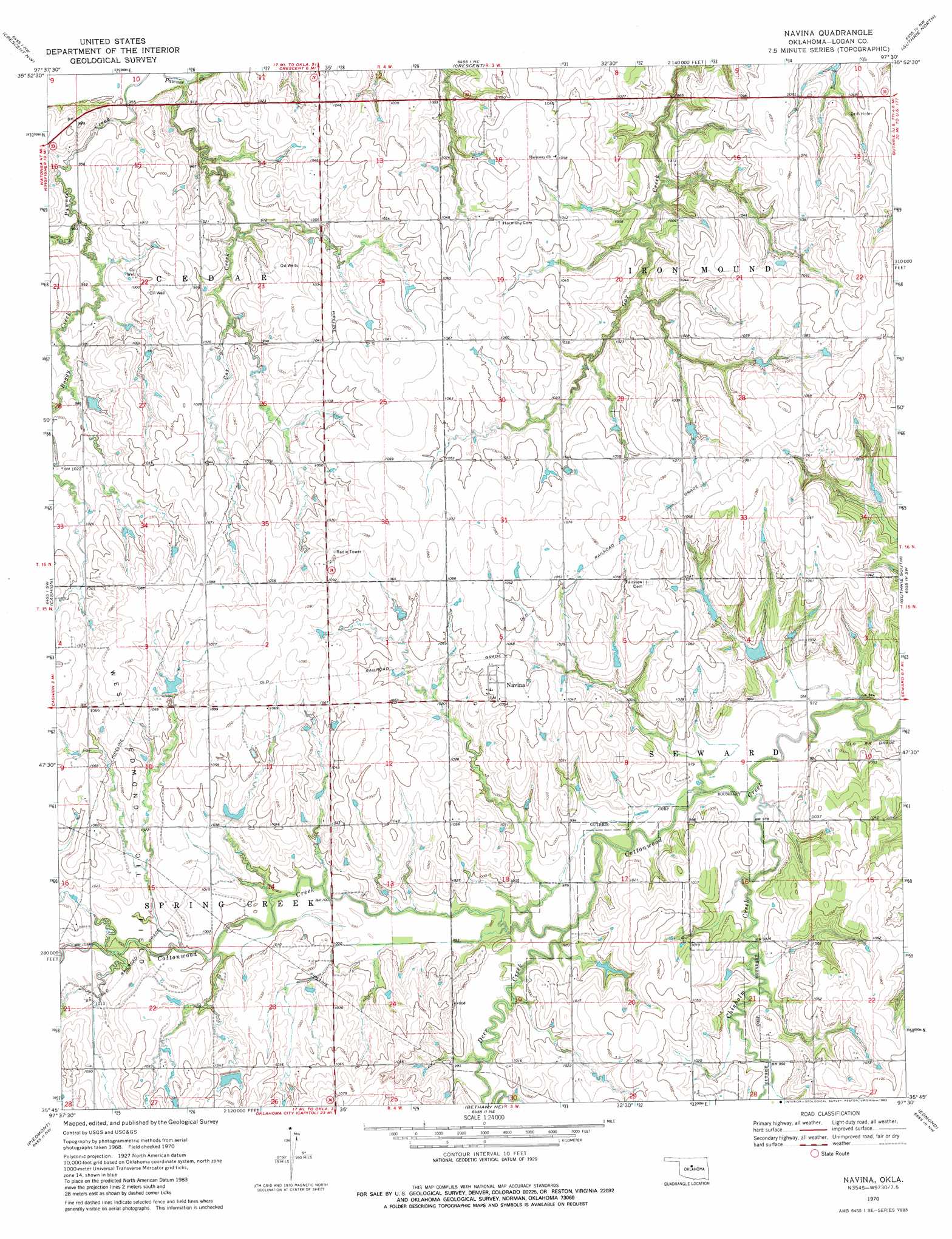
USGS Topo Quad 35097g5 - 1:24,000 scale
| Topo Map Name: | Navina |
| USGS Topo Quad ID: | 35097g5 |
| Print Size: | ca. 21 1/4" wide x 27" high |
| Southeast Coordinates: | 35.75° N latitude / 97.5° W longitude |
| Map Center Coordinates: | 35.8125° N latitude / 97.5625° W longitude |
| U.S. State: | OK |
| Filename: | o35097g5.jpg |
| Download Map JPG Image: | Navina topo map 1:24,000 scale |
| Map Type: | Topographic |
| Topo Series: | 7.5´ |
| Map Scale: | 1:24,000 |
| Source of Map Images: | United States Geological Survey (USGS) |
| Alternate Map Versions: |
Navina OK 1970, updated 1971 Download PDF Buy paper map Navina OK 1970, updated 1983 Download PDF Buy paper map Navina OK 2009 Download PDF Buy paper map Navina OK 2012 Download PDF Buy paper map Navina OK 2016 Download PDF Buy paper map |
1:24,000 Topo Quads surrounding Navina
Union |
Lovell |
Bridge Creek |
Mulhall |
Clear Creek |
Kingfisher Ne |
Crescent Nw |
Crescent |
Guthrie North |
Langston |
Kingfisher Se |
Cashion |
Navina |
Guthrie South |
Guthrie Se |
El Reno Ne |
Piedmont |
Bethany Ne |
Edmond |
Arcadia |
Richland |
Bethany |
Britton |
Spencer |
Jones |
> Back to 35097e1 at 1:100,000 scale
> Back to 35096a1 at 1:250,000 scale
> Back to U.S. Topo Maps home
Navina topo map: Gazetteer
Navina: Airports
The Highlands Airport elevation 323m 1059′Navina: Dams
Cottonwood Creek Site 5 Dam elevation 307m 1007′Cottonwood Creek Site 8 Dam elevation 313m 1026′
Oknoname 083031 Dam elevation 322m 1056′
Oknoname 083032 Dam elevation 309m 1013′
Oknoname 083042 Dam elevation 323m 1059′
Oknoname 083050 Dam elevation 303m 994′
Oknoname 087033 Dam elevation 324m 1062′
Navina: Populated Places
Cedar Valley elevation 316m 1036′Navina elevation 321m 1053′
Navina: Reservoirs
Cottonwood Creek Site 5 Reservoir elevation 307m 1007′Cottonwood Creek Site 8 Reservoir elevation 313m 1026′
Oknoname 083031 Reservoir elevation 322m 1056′
Oknoname 083032 Reservoir elevation 309m 1013′
Oknoname 083042 Reservoir elevation 323m 1059′
Oknoname 083050 Reservoir elevation 303m 994′
Oknoname 087033 Reservoir elevation 324m 1062′
Navina: Streams
Boggy Creek elevation 290m 951′Chisholm Creek elevation 294m 964′
Cox Creek elevation 287m 941′
Deer Creek elevation 297m 974′
Navina digital topo map on disk
Buy this Navina topo map showing relief, roads, GPS coordinates and other geographical features, as a high-resolution digital map file on DVD: