Cogar Topo Map Oklahoma
To zoom in, hover over the map of Cogar
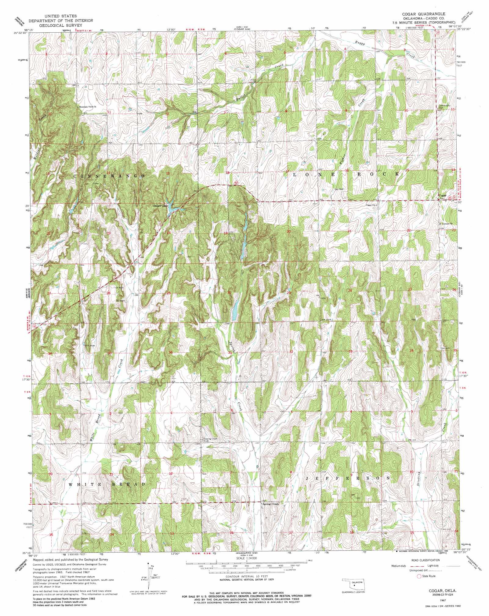
USGS Topo Quad 35098c2 - 1:24,000 scale
| Topo Map Name: | Cogar |
| USGS Topo Quad ID: | 35098c2 |
| Print Size: | ca. 21 1/4" wide x 27" high |
| Southeast Coordinates: | 35.25° N latitude / 98.125° W longitude |
| Map Center Coordinates: | 35.3125° N latitude / 98.1875° W longitude |
| U.S. State: | OK |
| Filename: | o35098c2.jpg |
| Download Map JPG Image: | Cogar topo map 1:24,000 scale |
| Map Type: | Topographic |
| Topo Series: | 7.5´ |
| Map Scale: | 1:24,000 |
| Source of Map Images: | United States Geological Survey (USGS) |
| Alternate Map Versions: |
Cogar OK 1967, updated 1969 Download PDF Buy paper map Cogar OK 1967, updated 1988 Download PDF Buy paper map Cogar OK 2009 Download PDF Buy paper map Cogar OK 2012 Download PDF Buy paper map Cogar OK 2016 Download PDF Buy paper map |
1:24,000 Topo Quads surrounding Cogar
Bridgeport |
Geary South |
Fort Reno Sw |
Fort Reno |
El Reno |
Rock Mary |
Hinton |
Cogar Nw |
Cogar Ne |
Union City |
Sickles |
Binger |
Cogar |
Cogar Se |
Minco |
Fort Cobb Dam |
Gracemont |
Anadarko Nw |
Anadarko Ne |
Pocasset |
Fort Cobb |
Anadarko West |
Anadarko East |
Verden |
Chickasha |
> Back to 35098a1 at 1:100,000 scale
> Back to 35098a1 at 1:250,000 scale
> Back to U.S. Topo Maps home
Cogar topo map: Gazetteer
Cogar: Dams
Okmoname 015009 Dam elevation 429m 1407′Oknoname 015008 Dam elevation 416m 1364′
Oknoname 015010 Dam elevation 447m 1466′
Salyer Lake Dam elevation 445m 1459′
Sugar Creek Site 31 Dam elevation 405m 1328′
Cogar: Populated Places
Cogar elevation 448m 1469′Spring Creek elevation 393m 1289′
Cogar: Reservoirs
Oknoname 015008 Reservoir elevation 416m 1364′Oknoname 015009 Reservoir elevation 429m 1407′
Oknoname 015010 Reservoir elevation 447m 1466′
Salyer Lake elevation 443m 1453′
Sugar Creek Site 31 Reservoir elevation 405m 1328′
Cogar: Streams
Fisher Creek elevation 427m 1400′Cogar digital topo map on disk
Buy this Cogar topo map showing relief, roads, GPS coordinates and other geographical features, as a high-resolution digital map file on DVD: