Rock Mary Topo Map Oklahoma
To zoom in, hover over the map of Rock Mary
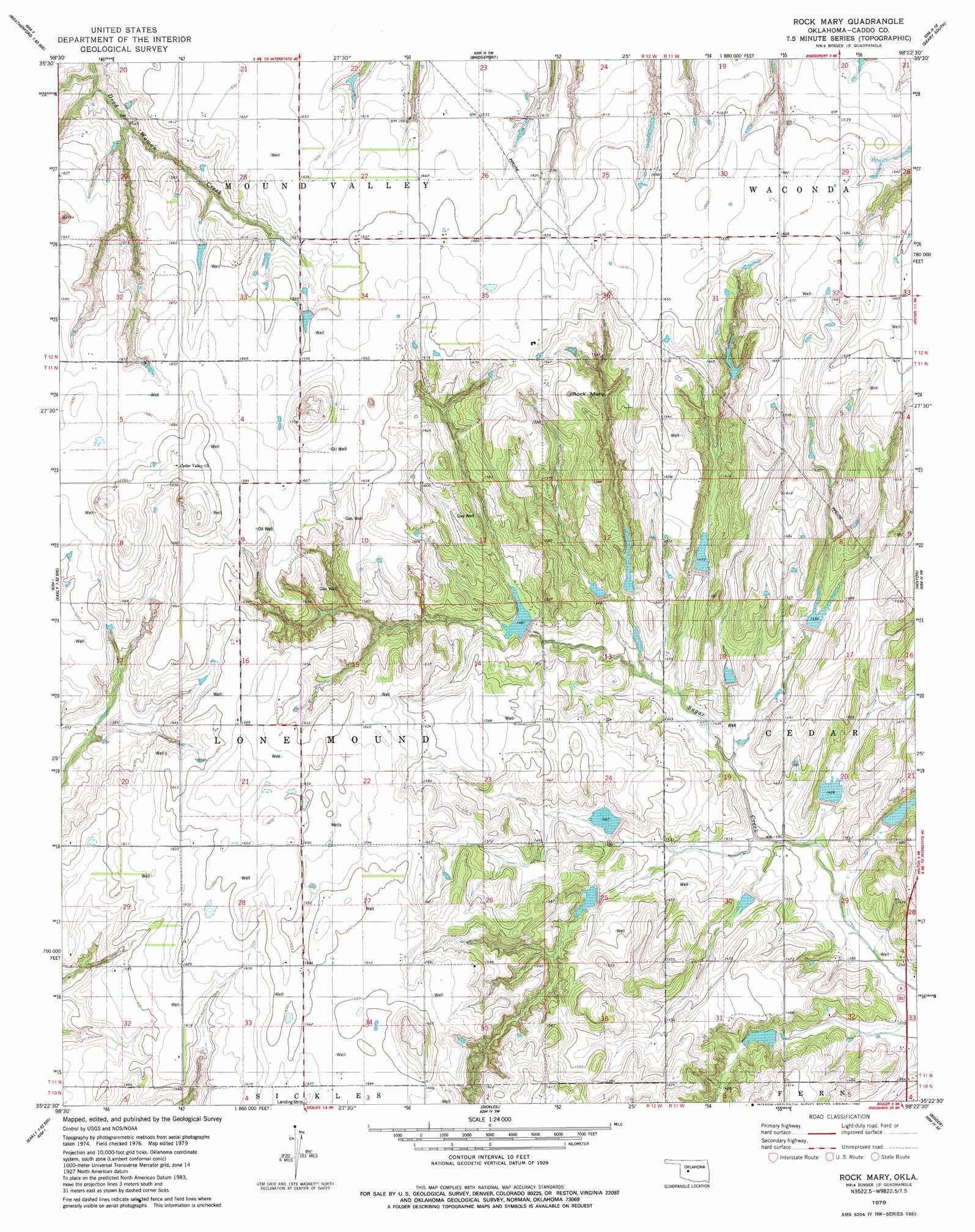
USGS Topo Quad 35098d4 - 1:24,000 scale
| Topo Map Name: | Rock Mary |
| USGS Topo Quad ID: | 35098d4 |
| Print Size: | ca. 21 1/4" wide x 27" high |
| Southeast Coordinates: | 35.375° N latitude / 98.375° W longitude |
| Map Center Coordinates: | 35.4375° N latitude / 98.4375° W longitude |
| U.S. State: | OK |
| Filename: | o35098d4.jpg |
| Download Map JPG Image: | Rock Mary topo map 1:24,000 scale |
| Map Type: | Topographic |
| Topo Series: | 7.5´ |
| Map Scale: | 1:24,000 |
| Source of Map Images: | United States Geological Survey (USGS) |
| Alternate Map Versions: |
Rock Mary OK 1979, updated 1979 Download PDF Buy paper map Rock Mary OK 1979, updated 1983 Download PDF Buy paper map Rock Mary OK 2009 Download PDF Buy paper map Rock Mary OK 2012 Download PDF Buy paper map Rock Mary OK 2016 Download PDF Buy paper map |
1:24,000 Topo Quads surrounding Rock Mary
Weatherford Nw |
Squaw Creek |
Greenfield |
Geary North |
Porcupine Butte |
Weatherford |
Hydro |
Bridgeport |
Geary South |
Fort Reno Sw |
Crowder Lake |
Eakly Ne |
Rock Mary |
Hinton |
Cogar Nw |
Colony |
Eakly |
Sickles |
Binger |
Cogar |
Cowden |
Alfalfa |
Fort Cobb Dam |
Gracemont |
Anadarko Nw |
> Back to 35098a1 at 1:100,000 scale
> Back to 35098a1 at 1:250,000 scale
> Back to U.S. Topo Maps home
Rock Mary topo map: Gazetteer
Rock Mary: Dams
Fast Runner Creek Site 3 Dam elevation 419m 1374′Fast Runner Site 1 Dam elevation 427m 1400′
Fast Runner Site 2 Dam elevation 421m 1381′
Oknoname 015020 Dam elevation 495m 1624′
Oknoname 015021 Dam elevation 468m 1535′
Oknoname 015025 Dam elevation 506m 1660′
Sugar Creek Site 11 Dam elevation 432m 1417′
Sugar Creek Site 12 Dam elevation 499m 1637′
Sugar Creek Site 13 Dam elevation 500m 1640′
Sugar Creek Site 14 Dam elevation 500m 1640′
Sugar Creek Site 15 Dam elevation 502m 1646′
Sugar Creek Site 20 Dam elevation 505m 1656′
Sugar Creek Site 29 Dam elevation 506m 1660′
Rock Mary: Pillars
Rock Mary elevation 510m 1673′Rock Mary: Reservoirs
Fast Runner Creek Site 3 Reservoir elevation 419m 1374′Fast Runner Site 1 Reservoir elevation 427m 1400′
Fast Runner Site 2 Reservoir elevation 421m 1381′
Oknoname 015020 Reservoir elevation 495m 1624′
Oknoname 015021 Reservoir elevation 468m 1535′
Oknoname 015025 Reservoir elevation 506m 1660′
Sugar Creek Site 11 Reservoir elevation 432m 1417′
Sugar Creek Site 12 Reservoir elevation 499m 1637′
Sugar Creek Site 13 Reservoir elevation 500m 1640′
Sugar Creek Site 14 Reservoir elevation 500m 1640′
Sugar Creek Site 15 Reservoir elevation 502m 1646′
Sugar Creek Site 20 Reservoir elevation 505m 1656′
Sugar Creek Site 29 Reservoir elevation 506m 1660′
Rock Mary digital topo map on disk
Buy this Rock Mary topo map showing relief, roads, GPS coordinates and other geographical features, as a high-resolution digital map file on DVD: