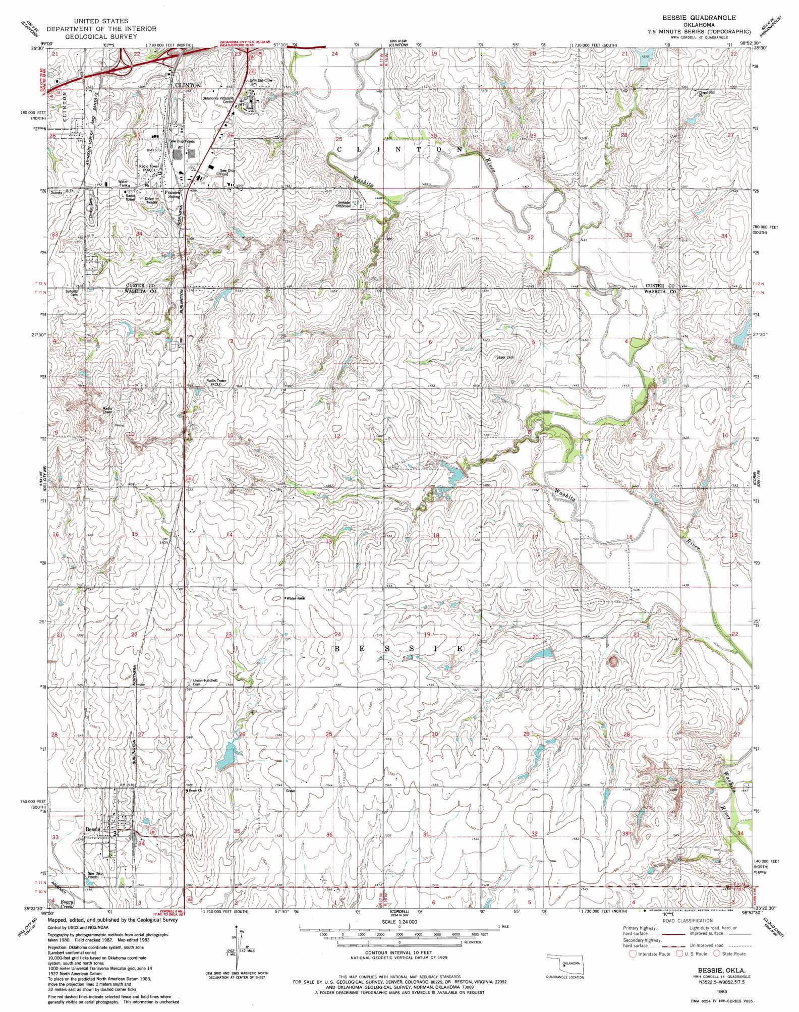
Bessie Topo Map Oklahoma
To zoom in, hover over the map of Bessie
USGS Topo Quad 35098d8 - 1:24,000 scale
| Topo Map Name: | Bessie |
| USGS Topo Quad ID: | 35098d8 |
| Print Size: | ca. 21 1/4" wide x 27" high |
| Southeast Coordinates: | 35.375° N latitude / 98.875° W longitude |
| Map Center Coordinates: | 35.4375° N latitude / 98.9375° W longitude |
| U.S. State: | OK |
| Filename: | o35098d8.jpg |
| Download Map JPG Image: | Bessie topo map 1:24,000 scale |
| Map Type: | Topographic |
| Topo Series: | 7.5´ |
| Map Scale: | 1:24,000 |
| Source of Map Images: | United States Geological Survey (USGS) |
| Alternate Map Versions: |
Bessie OK 1983, updated 1984 Download PDF Buy paper map Bessie OK 2010 Download PDF Buy paper map Bessie OK 2012 Download PDF Buy paper map Bessie OK 2016 Download PDF Buy paper map |
1:24,000 Topo Quads surrounding Bessie
Butler |
Anthon |
Custer City |
Clinton Ne |
Weatherford Nw |
Foss Dam |
Stafford |
Clinton |
Indianapolis |
Weatherford |
Foss |
Dill City Ne |
Bessie |
Corn |
Crowder Lake |
Dill City |
Dill City Se |
Cordell |
Cloud Chief |
Colony |
Sentinel |
Rocky |
Gotebo Nw |
Lake Valley |
Cowden |
> Back to 35098a1 at 1:100,000 scale
> Back to 35098a1 at 1:250,000 scale
> Back to U.S. Topo Maps home
Bessie topo map: Gazetteer
Bessie: Dams
Bear Creek Site 2 Dam elevation 461m 1512′Bear Creek Site 3 Dam elevation 466m 1528′
Bear Creek Site 4 Dam elevation 472m 1548′
Bear Creek Site 5 Dam elevation 467m 1532′
Boggy Creek Watershed Site 27 Dam elevation 464m 1522′
Boggy Creek Watershed Site 28 Dam elevation 464m 1522′
Buehler Dam elevation 471m 1545′
Oknoname 149001 Dam elevation 438m 1437′
South Clinton Laterals Number 101 Dam elevation 509m 1669′
South Clinton Laterals Site 102 Dam elevation 479m 1571′
South Clinton Laterals Site 6 Dam elevation 480m 1574′
South Clinton Laterals Site 7 Dam elevation 447m 1466′
South Clinton Laterals Site L-14 Dam elevation 466m 1528′
South Clinton Laterals Site L16 Dam elevation 457m 1499′
South Clinton Laterals Site L17 Dam elevation 461m 1512′
Bessie: Populated Places
Bessie elevation 473m 1551′Bessie: Reservoirs
Bear Creek Site 2 Reservoir elevation 461m 1512′Bear Creek Site 3 Reservoir elevation 466m 1528′
Bear Creek Site 4 Reservoir elevation 472m 1548′
Bear Creek Site 5 Reservoir elevation 467m 1532′
Boggy Creek Watershed Site 27 Reservoir elevation 464m 1522′
Boggy Creek Watershed Site 28 Reservoir elevation 464m 1522′
Buehler Reservoir elevation 471m 1545′
Oknoname 149001 Reservoir elevation 438m 1437′
South Clinton Laterals Number 101 Reservoir elevation 509m 1669′
South Clinton Laterals Site 102 Reservoir elevation 479m 1571′
South Clinton Laterals Site 6 Reservoir elevation 480m 1574′
South Clinton Laterals Site 7 Reservoir elevation 447m 1466′
South Clinton Laterals Site L-14 Reservoir elevation 466m 1528′
South Clinton Laterals Site L16 Reservoir elevation 457m 1499′
South Clinton Laterals Site L17 Reservoir elevation 461m 1512′
Bessie digital topo map on disk
Buy this Bessie topo map showing relief, roads, GPS coordinates and other geographical features, as a high-resolution digital map file on DVD: