Mcdowell Creek Topo Map Texas
To zoom in, hover over the map of Mcdowell Creek
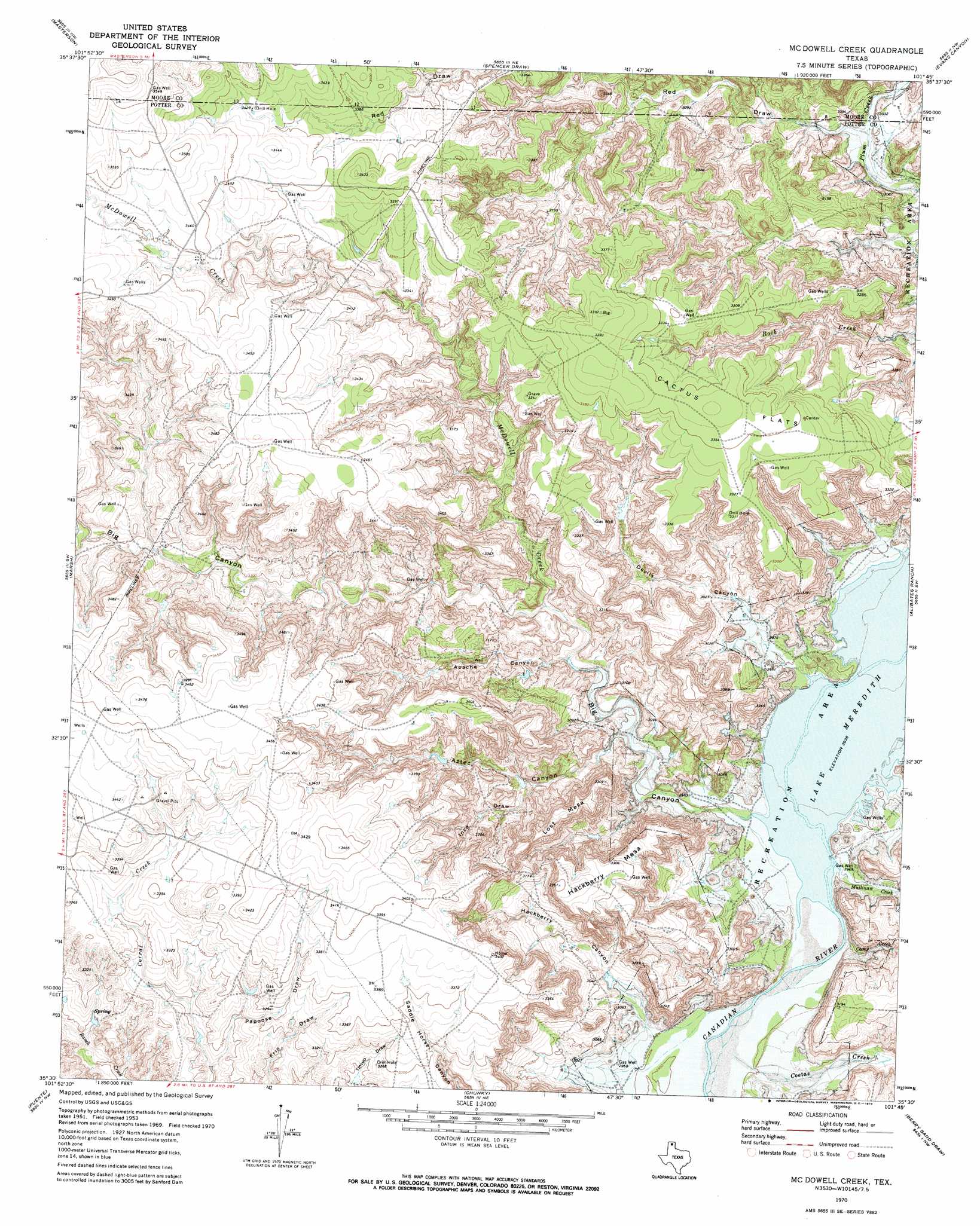
USGS Topo Quad 35101e7 - 1:24,000 scale
| Topo Map Name: | Mcdowell Creek |
| USGS Topo Quad ID: | 35101e7 |
| Print Size: | ca. 21 1/4" wide x 27" high |
| Southeast Coordinates: | 35.5° N latitude / 101.75° W longitude |
| Map Center Coordinates: | 35.5625° N latitude / 101.8125° W longitude |
| U.S. State: | TX |
| Filename: | o35101e7.jpg |
| Download Map JPG Image: | Mcdowell Creek topo map 1:24,000 scale |
| Map Type: | Topographic |
| Topo Series: | 7.5´ |
| Map Scale: | 1:24,000 |
| Source of Map Images: | United States Geological Survey (USGS) |
| Alternate Map Versions: |
McDowell Creek TX 1953, updated 1954 Download PDF Buy paper map McDowell Creek TX 1970, updated 1973 Download PDF Buy paper map McDowell Creek TX 2010 Download PDF Buy paper map McDowell Creek TX 2012 Download PDF Buy paper map McDowell Creek TX 2016 Download PDF Buy paper map |
1:24,000 Topo Quads surrounding Mcdowell Creek
Stallwitz Lake |
Dumas South |
Little Blue Creek |
Pollard Creek |
Camp Creek |
Bautista |
Masterson |
Spencer Draw |
Evans Canyon |
Sanford |
Little Indian Creek |
Marsh |
Mcdowell Creek |
Alibates Ranch |
Deal |
Boden |
Puente |
Chunky |
Berry Sand Draw |
Pomeroy |
Wolf Mountain |
Cliffside |
Pleasant Valley |
Mayer |
Sevenmile Basin |
> Back to 35101e1 at 1:100,000 scale
> Back to 35100a1 at 1:250,000 scale
> Back to U.S. Topo Maps home
Mcdowell Creek topo map: Gazetteer
Mcdowell Creek: Flats
Cactus Flats elevation 1025m 3362′Mcdowell Creek: Streams
Camp Creek elevation 896m 2939′Coetas Creek elevation 899m 2949′
McDowell Creek elevation 896m 2939′
Mullinaw Creek elevation 896m 2939′
Mcdowell Creek: Summits
Hackberry Mesa elevation 1011m 3316′Lost Mesa elevation 1013m 3323′
Mcdowell Creek: Valleys
Apache Canyon elevation 917m 3008′Aztec Canyon elevation 904m 2965′
Big Canyon elevation 897m 2942′
Devils Canyon elevation 897m 2942′
Hackberry Canyon elevation 902m 2959′
Inca Draw elevation 927m 3041′
Papoose Draw elevation 976m 3202′
Mcdowell Creek digital topo map on disk
Buy this Mcdowell Creek topo map showing relief, roads, GPS coordinates and other geographical features, as a high-resolution digital map file on DVD: