Humdinger Spring Topo Map Texas
To zoom in, hover over the map of Humdinger Spring
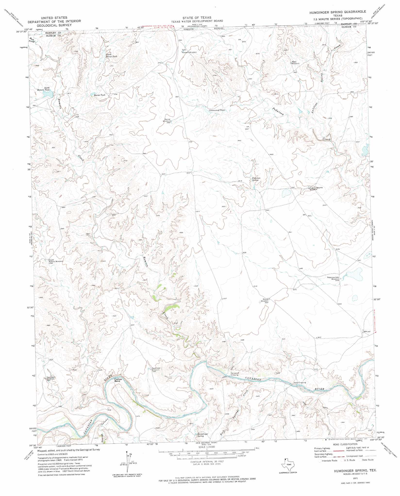
USGS Topo Quad 35102e6 - 1:24,000 scale
| Topo Map Name: | Humdinger Spring |
| USGS Topo Quad ID: | 35102e6 |
| Print Size: | ca. 21 1/4" wide x 27" high |
| Southeast Coordinates: | 35.5° N latitude / 102.625° W longitude |
| Map Center Coordinates: | 35.5625° N latitude / 102.6875° W longitude |
| U.S. State: | TX |
| Filename: | o35102e6.jpg |
| Download Map JPG Image: | Humdinger Spring topo map 1:24,000 scale |
| Map Type: | Topographic |
| Topo Series: | 7.5´ |
| Map Scale: | 1:24,000 |
| Source of Map Images: | United States Geological Survey (USGS) |
| Alternate Map Versions: |
Humdinger Spring TX 1971, updated 1974 Download PDF Buy paper map Humdinger Spring TX 2010 Download PDF Buy paper map Humdinger Spring TX 2012 Download PDF Buy paper map Humdinger Spring TX 2016 Download PDF Buy paper map |
1:24,000 Topo Quads surrounding Humdinger Spring
Whiteaker Ranch |
Middle Water |
King Sw |
King Se |
Hartley Sw |
Romero |
Spring Creek Ranch |
Pedarosa Camp |
Proctor Ranch |
Channing Nw |
Knoblaw |
Romero Se |
Humdinger Spring |
Many Post Camp |
Torrey House |
Trujillo Camp |
Vat Camp |
Big George Tank |
Alamocitos Camp |
Torrea Peak |
Signal Spring |
Signal Spring Se |
Adrian |
Landergin |
Vega North |
> Back to 35102e1 at 1:100,000 scale
> Back to 35102a1 at 1:250,000 scale
> Back to U.S. Topo Maps home
Humdinger Spring topo map: Gazetteer
Humdinger Spring: Arroyos
Buck Arroyo elevation 1100m 3608′Humdinger Spring: Bends
Catfish Bend elevation 1021m 3349′Humdinger Spring: Dams
Martha Houghton Lake Number 5 Dam elevation 1100m 3608′Humdinger Spring: Populated Places
Partwood Crossing elevation 1015m 3330′Strip Crossing elevation 1016m 3333′
Humdinger Spring: Reservoirs
Cottonwood Tank elevation 1107m 3631′Martha Houghton Lake Number 5 elevation 1100m 3608′
North Reeves Tank elevation 1120m 3674′
North Romero Tank elevation 1101m 3612′
Reeves Tank elevation 1111m 3645′
Humdinger Spring: Springs
Humdinger Spring elevation 1031m 3382′Pedarosa Spring elevation 1095m 3592′
Pedarosa Springs elevation 1115m 3658′
Humdinger Spring: Streams
Antelope Spring Creek elevation 1066m 3497′Las Arches Creek elevation 1027m 3369′
Rock Springs Creek elevation 1016m 3333′
Romero Creek elevation 1017m 3336′
Humdinger Spring: Valleys
Buck Arroyo elevation 1101m 3612′George Canyon elevation 1024m 3359′
Humdinger Spring digital topo map on disk
Buy this Humdinger Spring topo map showing relief, roads, GPS coordinates and other geographical features, as a high-resolution digital map file on DVD: