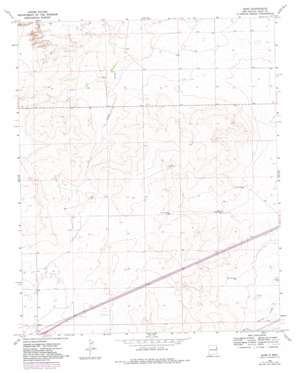
Bard Topo Map New Mexico
To zoom in, hover over the map of Bard
USGS Topo Quad 35103b2 - 1:24,000 scale
| Topo Map Name: | Bard |
| USGS Topo Quad ID: | 35103b2 |
| Print Size: | ca. 21 1/4" wide x 27" high |
| Southeast Coordinates: | 35.125° N latitude / 103.125° W longitude |
| Map Center Coordinates: | 35.1875° N latitude / 103.1875° W longitude |
| U.S. State: | NM |
| Filename: | o35103b2.jpg |
| Download Map JPG Image: | Bard topo map 1:24,000 scale |
| Map Type: | Topographic |
| Topo Series: | 7.5´ |
| Map Scale: | 1:24,000 |
| Source of Map Images: | United States Geological Survey (USGS) |
| Alternate Map Versions: |
Bard NM 1968, updated 1971 Download PDF Buy paper map Bard NM 1968, updated 1982 Download PDF Buy paper map Bard NM 2010 Download PDF Buy paper map Bard NM 2013 Download PDF Buy paper map Bard NM 2017 Download PDF Buy paper map |
1:24,000 Topo Quads surrounding Bard
> Back to 35103a1 at 1:100,000 scale
> Back to 35102a1 at 1:250,000 scale
> Back to U.S. Topo Maps home
Bard topo map: Gazetteer
Bard: Populated Places
Bard elevation 1220m 4002′Bard: Post Offices
Bard Post Office elevation 1217m 3992′Bard: Wells
05204 Water Well elevation 1213m 3979′05414 Water Well elevation 1183m 3881′
05415 Water Well elevation 1195m 3920′
05416 Water Well elevation 1184m 3884′
05417 Water Well elevation 1187m 3894′
05420 Water Well elevation 1244m 4081′
05421 Water Well elevation 1211m 3973′
05422 Water Well elevation 1202m 3943′
05423 Water Well elevation 1214m 3982′
05434 Water Well elevation 1189m 3900′
05435 Water Well elevation 1183m 3881′
05439 Water Well elevation 1192m 3910′
05440 Water Well elevation 1201m 3940′
05441 Water Well elevation 1195m 3920′
05532 Water Well elevation 1232m 4041′
05533 Water Well elevation 1241m 4071′
05534 Water Well elevation 1232m 4041′
05542 Water Well elevation 1227m 4025′
05543 Water Well elevation 1238m 4061′
05544 Water Well elevation 1225m 4019′
05545 Water Well elevation 1214m 3982′
05546 Water Well elevation 1218m 3996′
05547 Water Well elevation 1256m 4120′
05550 Water Well elevation 1222m 4009′
05551 Water Well elevation 1226m 4022′
05552 Water Well elevation 1226m 4022′
05553 Water Well elevation 1216m 3989′
05554 Water Well elevation 1236m 4055′
05555 Water Well elevation 1225m 4019′
05556 Water Well elevation 1220m 4002′
05559 Water Well elevation 1224m 4015′
05561 Water Well elevation 1220m 4002′
05562 Water Well elevation 1222m 4009′
05563 Water Well elevation 1223m 4012′
05564 Water Well elevation 1234m 4048′
05565 Water Well elevation 1221m 4005′
05566 Water Well elevation 1205m 3953′
05569 Water Well elevation 1248m 4094′
05573 Water Well elevation 1182m 3877′
05574 Water Well elevation 1190m 3904′
05577 Water Well elevation 1176m 3858′
Bard digital topo map on disk
Buy this Bard topo map showing relief, roads, GPS coordinates and other geographical features, as a high-resolution digital map file on DVD:


