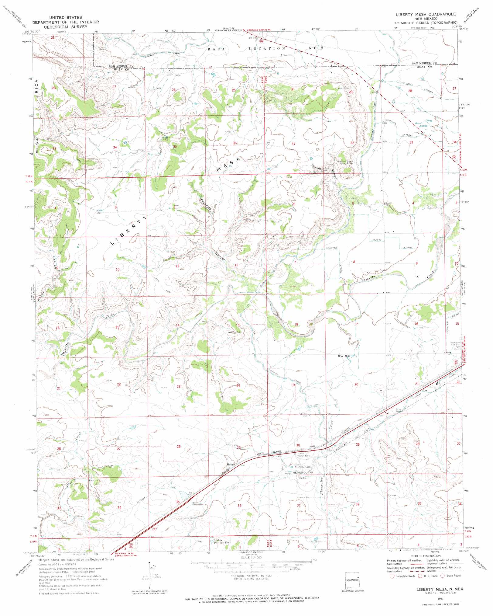
Liberty Mesa Topo Map New Mexico
To zoom in, hover over the map of Liberty Mesa
USGS Topo Quad 35103b7 - 1:24,000 scale
| Topo Map Name: | Liberty Mesa |
| USGS Topo Quad ID: | 35103b7 |
| Print Size: | ca. 21 1/4" wide x 27" high |
| Southeast Coordinates: | 35.125° N latitude / 103.75° W longitude |
| Map Center Coordinates: | 35.1875° N latitude / 103.8125° W longitude |
| U.S. State: | NM |
| Filename: | o35103b7.jpg |
| Download Map JPG Image: | Liberty Mesa topo map 1:24,000 scale |
| Map Type: | Topographic |
| Topo Series: | 7.5´ |
| Map Scale: | 1:24,000 |
| Source of Map Images: | United States Geological Survey (USGS) |
| Alternate Map Versions: |
Liberty Mesa NM 1967, updated 1971 Download PDF Buy paper map Liberty Mesa NM 2010 Download PDF Buy paper map Liberty Mesa NM 2013 Download PDF Buy paper map Liberty Mesa NM 2017 Download PDF Buy paper map |
1:24,000 Topo Quads surrounding Liberty Mesa
La Cinta Mesa |
Carpenter Mesa Nw |
Medina Mesa |
Hampton Ranch |
Montesito Creek |
Monument Point |
Carpenter Mesa Sw |
Trinchera Creek |
Bascom Camp |
Hudson |
Muniz Canyon |
Cow Canyon |
Liberty Mesa |
Tucumcari |
Lesbia |
Montoya |
Quemado Hills |
Briscoe Ranch |
Bulldog Mesa |
Tucumcari Se |
Ima |
Circle S Mesa |
Quay |
Mesa Redonda |
Norton |
> Back to 35103a1 at 1:100,000 scale
> Back to 35102a1 at 1:250,000 scale
> Back to U.S. Topo Maps home
Liberty Mesa topo map: Gazetteer
Liberty Mesa: Canals
Coulter Lateral elevation 1236m 4055′Liberty Lateral elevation 1226m 4022′
Roberts Lateral elevation 1236m 4055′
Liberty Mesa: Lakes
Blue Hole elevation 1226m 4022′Liberty Mesa: Parks
Tucumcari Metropolitan Park elevation 1251m 4104′Liberty Mesa: Populated Places
Hargis elevation 1279m 4196′Liberty Mesa: Reservoirs
Middle Pasture Tank elevation 1312m 4304′Liberty Mesa: Streams
Blanca Creek elevation 1244m 4081′Bluewater Creek elevation 1219m 3999′
Liberty Mesa: Summits
Liberty Mesa elevation 1343m 4406′Liberty Mesa: Valleys
Dickie Canyon elevation 1232m 4041′Hondo Canyon elevation 1244m 4081′
Pajarito Canyon elevation 1230m 4035′
Liberty Mesa: Wells
10107 Water Well elevation 1274m 4179′10108 Water Well elevation 1233m 4045′
10109 Water Well elevation 1250m 4101′
10110 Water Well elevation 1263m 4143′
10112 Water Well elevation 1276m 4186′
10113 Water Well elevation 1274m 4179′
10115 Water Well elevation 1317m 4320′
10116 Water Well elevation 1262m 4140′
10117 Water Well elevation 1230m 4035′
10118 Water Well elevation 1229m 4032′
10119 Water Well elevation 1223m 4012′
10120 Water Well elevation 1220m 4002′
10129 Water Well elevation 1247m 4091′
10133 Water Well elevation 1231m 4038′
10134 Water Well elevation 1236m 4055′
10135 Water Well elevation 1265m 4150′
10136 Water Well elevation 1243m 4078′
10137 Water Well elevation 1248m 4094′
10138 Water Well elevation 1252m 4107′
10140 Water Well elevation 1256m 4120′
10146 Water Well elevation 1254m 4114′
10147 Water Well elevation 1256m 4120′
10148 Water Well elevation 1255m 4117′
Liberty Mesa digital topo map on disk
Buy this Liberty Mesa topo map showing relief, roads, GPS coordinates and other geographical features, as a high-resolution digital map file on DVD: