Sanchez Springs Topo Map New Mexico
To zoom in, hover over the map of Sanchez Springs
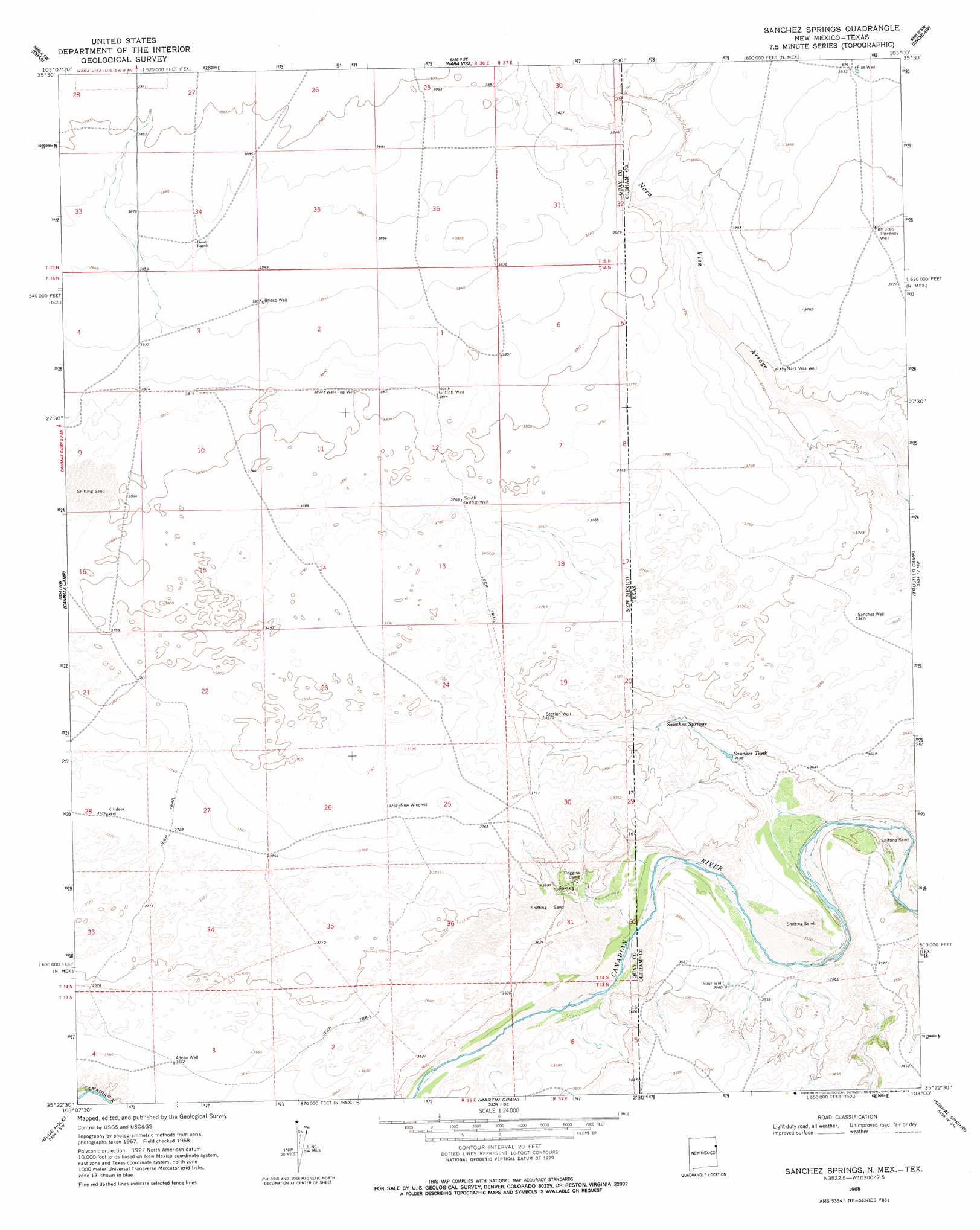
USGS Topo Quad 35103d1 - 1:24,000 scale
| Topo Map Name: | Sanchez Springs |
| USGS Topo Quad ID: | 35103d1 |
| Print Size: | ca. 21 1/4" wide x 27" high |
| Southeast Coordinates: | 35.375° N latitude / 103° W longitude |
| Map Center Coordinates: | 35.4375° N latitude / 103.0625° W longitude |
| U.S. States: | NM, TX |
| Filename: | o35103d1.jpg |
| Download Map JPG Image: | Sanchez Springs topo map 1:24,000 scale |
| Map Type: | Topographic |
| Topo Series: | 7.5´ |
| Map Scale: | 1:24,000 |
| Source of Map Images: | United States Geological Survey (USGS) |
| Alternate Map Versions: |
Sanchez Springs TX 1968, updated 1971 Download PDF Buy paper map Sanchez Springs TX 1968, updated 1978 Download PDF Buy paper map Sanchez Springs TX 2010 Download PDF Buy paper map Sanchez Springs TX 2012 Download PDF Buy paper map Sanchez Springs TX 2016 Download PDF Buy paper map |
1:24,000 Topo Quads surrounding Sanchez Springs
Cherokee Valley |
Kerlin Hill |
Doyle Hill |
Romero |
Spring Creek Ranch |
Lockney |
Obar |
Nara Visa |
Knoblaw |
Romero Se |
Logan Ne |
Cammak Camp |
Sanchez Springs |
Trujillo Camp |
Vat Camp |
Tuscocoillo Canyon |
Blue Hole |
Martin Draw |
Signal Spring |
Signal Spring Se |
Porter |
Bard |
Glenrio |
Moser Ranch |
Boise |
> Back to 35103a1 at 1:100,000 scale
> Back to 35102a1 at 1:250,000 scale
> Back to U.S. Topo Maps home
Sanchez Springs topo map: Gazetteer
Sanchez Springs: Reservoirs
Sanchez Tank elevation 1084m 3556′Sanchez Springs: Springs
Sanchez Spring elevation 1100m 3608′Sanchez Springs: Streams
Nara Visa Arroyo elevation 1103m 3618′Sanchez Springs: Wells
Adobe Well elevation 1118m 3667′Brisco Well elevation 1171m 3841′
Flat Well elevation 1170m 3838′
Killdeer Well elevation 1136m 3727′
Nara Visa Well elevation 1139m 3736′
North Griffith Well elevation 1162m 3812′
Sanchez Well elevation 1120m 3674′
Section Well elevation 1122m 3681′
Sour Well elevation 1085m 3559′
South Griffith Well elevation 1152m 3779′
Threeway Well elevation 1155m 3789′
Walk-up-well elevation 1161m 3809′
Sanchez Springs digital topo map on disk
Buy this Sanchez Springs topo map showing relief, roads, GPS coordinates and other geographical features, as a high-resolution digital map file on DVD: