Obar Topo Map New Mexico
To zoom in, hover over the map of Obar
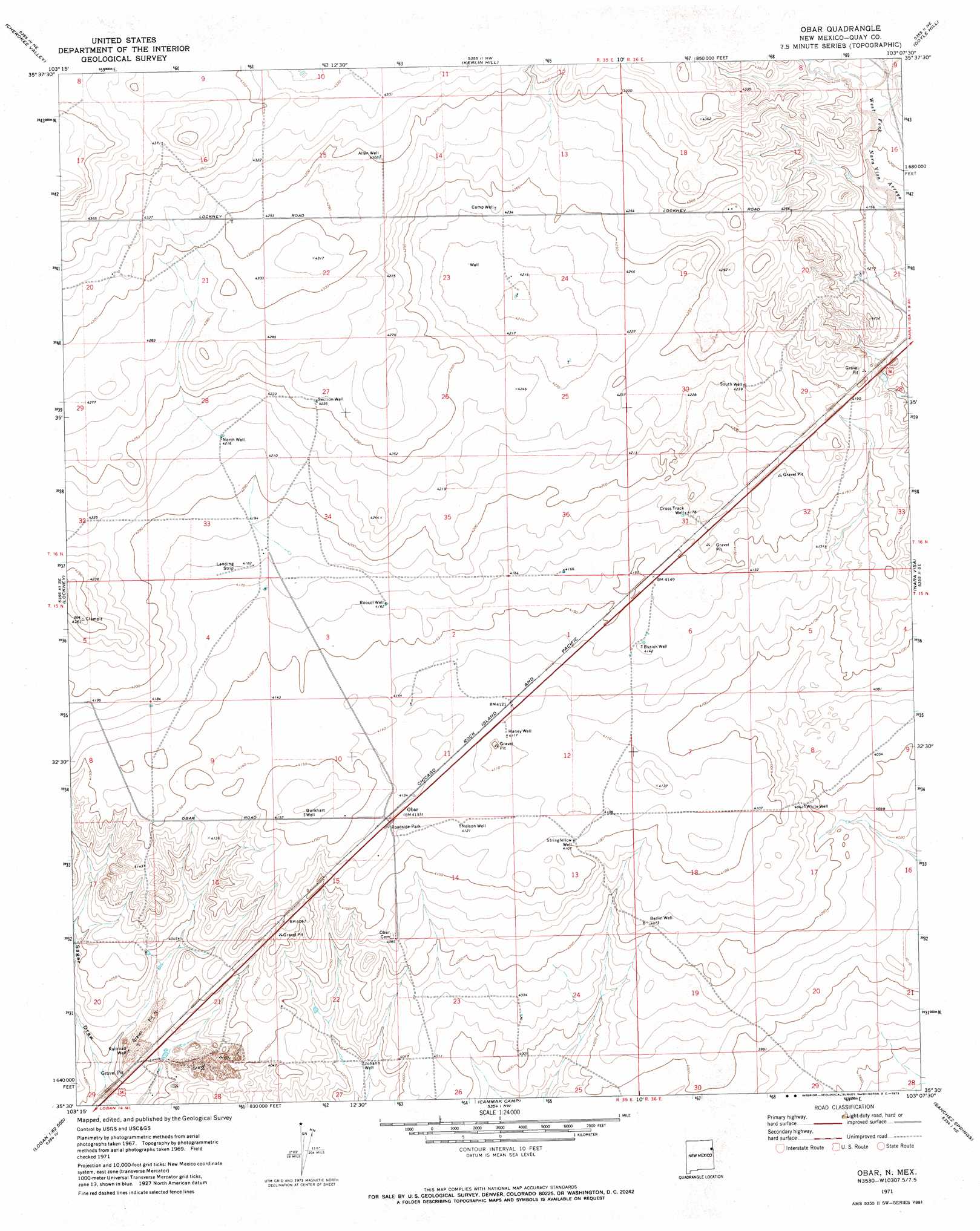
USGS Topo Quad 35103e2 - 1:24,000 scale
| Topo Map Name: | Obar |
| USGS Topo Quad ID: | 35103e2 |
| Print Size: | ca. 21 1/4" wide x 27" high |
| Southeast Coordinates: | 35.5° N latitude / 103.125° W longitude |
| Map Center Coordinates: | 35.5625° N latitude / 103.1875° W longitude |
| U.S. State: | NM |
| Filename: | o35103e2.jpg |
| Download Map JPG Image: | Obar topo map 1:24,000 scale |
| Map Type: | Topographic |
| Topo Series: | 7.5´ |
| Map Scale: | 1:24,000 |
| Source of Map Images: | United States Geological Survey (USGS) |
| Alternate Map Versions: |
Obar NM 1971, updated 1973 Download PDF Buy paper map Obar NM 2010 Download PDF Buy paper map Obar NM 2013 Download PDF Buy paper map Obar NM 2017 Download PDF Buy paper map |
1:24,000 Topo Quads surrounding Obar
Rosebud |
Ione |
Centerville Corner |
Amistad Se |
Whiteaker Ranch |
Mccloy Ranch |
Cherokee Valley |
Kerlin Hill |
Doyle Hill |
Romero |
Mccarty Ranch |
Lockney |
Obar |
Nara Visa |
Knoblaw |
Logan North |
Logan Ne |
Cammak Camp |
Sanchez Springs |
Trujillo Camp |
Logan South |
Tuscocoillo Canyon |
Blue Hole |
Martin Draw |
Signal Spring |
> Back to 35103e1 at 1:100,000 scale
> Back to 35102a1 at 1:250,000 scale
> Back to U.S. Topo Maps home
Obar topo map: Gazetteer
Obar: Populated Places
Obar elevation 1259m 4130′Obar: Post Offices
Obar Post Office (historical) elevation 1259m 4130′Obar: Wells
00515 Water Well elevation 1255m 4117′05264 Water Well elevation 1268m 4160′
05267 Water Well elevation 1256m 4120′
05269 Water Well elevation 1219m 3999′
05270 Water Well elevation 1226m 4022′
05272 Water Well elevation 1234m 4048′
05273 Water Well elevation 1227m 4025′
05299 Water Well elevation 1286m 4219′
05300 Water Well elevation 1283m 4209′
05301 Water Well elevation 1295m 4248′
05307 Water Well elevation 1305m 4281′
05309 Water Well elevation 1276m 4186′
05315 Water Well elevation 1293m 4242′
05454 Water Well elevation 1293m 4242′
05466 Water Well elevation 1258m 4127′
05476 Water Well elevation 1272m 4173′
05478 Water Well elevation 1224m 4015′
Allen Well elevation 1312m 4304′
Berlin Well elevation 1241m 4071′
Burkhart Well elevation 1271m 4169′
Busick Well elevation 1262m 4140′
Camp Well elevation 1293m 4242′
Cross Track Well elevation 1274m 4179′
Haney Well elevation 1254m 4114′
Johann Well elevation 1217m 3992′
Nelson Well elevation 1257m 4124′
North Well elevation 1286m 4219′
Railroad Well elevation 1224m 4015′
Roocol Well elevation 1270m 4166′
Section Well elevation 1298m 4258′
South Well elevation 1293m 4242′
Stringfellow Well elevation 1252m 4107′
White Well elevation 1239m 4064′
Obar digital topo map on disk
Buy this Obar topo map showing relief, roads, GPS coordinates and other geographical features, as a high-resolution digital map file on DVD: