Lockney Topo Map New Mexico
To zoom in, hover over the map of Lockney
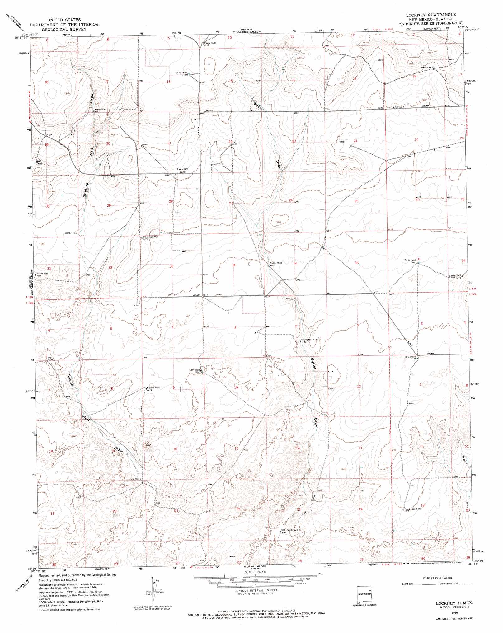
USGS Topo Quad 35103e3 - 1:24,000 scale
| Topo Map Name: | Lockney |
| USGS Topo Quad ID: | 35103e3 |
| Print Size: | ca. 21 1/4" wide x 27" high |
| Southeast Coordinates: | 35.5° N latitude / 103.25° W longitude |
| Map Center Coordinates: | 35.5625° N latitude / 103.3125° W longitude |
| U.S. State: | NM |
| Filename: | o35103e3.jpg |
| Download Map JPG Image: | Lockney topo map 1:24,000 scale |
| Map Type: | Topographic |
| Topo Series: | 7.5´ |
| Map Scale: | 1:24,000 |
| Source of Map Images: | United States Geological Survey (USGS) |
| Alternate Map Versions: |
Lockney NM 1966, updated 1969 Download PDF Buy paper map Lockney NM 2010 Download PDF Buy paper map Lockney NM 2013 Download PDF Buy paper map Lockney NM 2017 Download PDF Buy paper map |
1:24,000 Topo Quads surrounding Lockney
Indian Bathtub |
Rosebud |
Ione |
Centerville Corner |
Amistad Se |
Gallegos Ne |
Mccloy Ranch |
Cherokee Valley |
Kerlin Hill |
Doyle Hill |
Fuentes Ranch |
Mccarty Ranch |
Lockney |
Obar |
Nara Visa |
Montesito Creek |
Logan North |
Logan Ne |
Cammak Camp |
Sanchez Springs |
Hudson |
Logan South |
Tuscocoillo Canyon |
Blue Hole |
Martin Draw |
> Back to 35103e1 at 1:100,000 scale
> Back to 35102a1 at 1:250,000 scale
> Back to U.S. Topo Maps home
Lockney topo map: Gazetteer
Lockney: Post Offices
Lockney Post Office (historical) elevation 1329m 4360′Lockney: Reservoirs
Bell Tank elevation 1338m 4389′Lockney: Valleys
Butler Draw elevation 1234m 4048′Lockney: Wells
05260 Water Well elevation 1291m 4235′05261 Water Well elevation 1295m 4248′
05268 Water Well elevation 1269m 4163′
05289 Water Well elevation 1327m 4353′
05291 Water Well elevation 1326m 4350′
05292 Water Well elevation 1327m 4353′
05293 Water Well elevation 1316m 4317′
05294 Water Well elevation 1311m 4301′
05295 Water Well elevation 1295m 4248′
05445 Water Well elevation 1356m 4448′
05446 Water Well elevation 1328m 4356′
05447 Water Well elevation 1360m 4461′
05448 Water Well elevation 1348m 4422′
05449 Water Well elevation 1337m 4386′
05450 Water Well elevation 1320m 4330′
05451 Water Well elevation 1306m 4284′
05452 Water Well elevation 1299m 4261′
05474 Water Well elevation 1280m 4199′
05477 Water Well elevation 1258m 4127′
Brice Well elevation 1278m 4192′
Bryant Well elevation 1287m 4222′
Butler Well elevation 1289m 4229′
Carrol Well elevation 1285m 4215′
Etheridge Well elevation 1314m 4311′
Frampton Well elevation 1274m 4179′
Haney Well elevation 1338m 4389′
Kelly Well elevation 1281m 4202′
Keyes Well elevation 1335m 4379′
New Saggert Well elevation 1249m 4097′
Old Ranch Well elevation 1234m 4048′
Payne Well elevation 1360m 4461′
Smith Well elevation 1290m 4232′
Twin Wells elevation 1253m 4110′
Willis Well elevation 1361m 4465′
Lockney digital topo map on disk
Buy this Lockney topo map showing relief, roads, GPS coordinates and other geographical features, as a high-resolution digital map file on DVD: