Mccarty Ranch Topo Map New Mexico
To zoom in, hover over the map of Mccarty Ranch
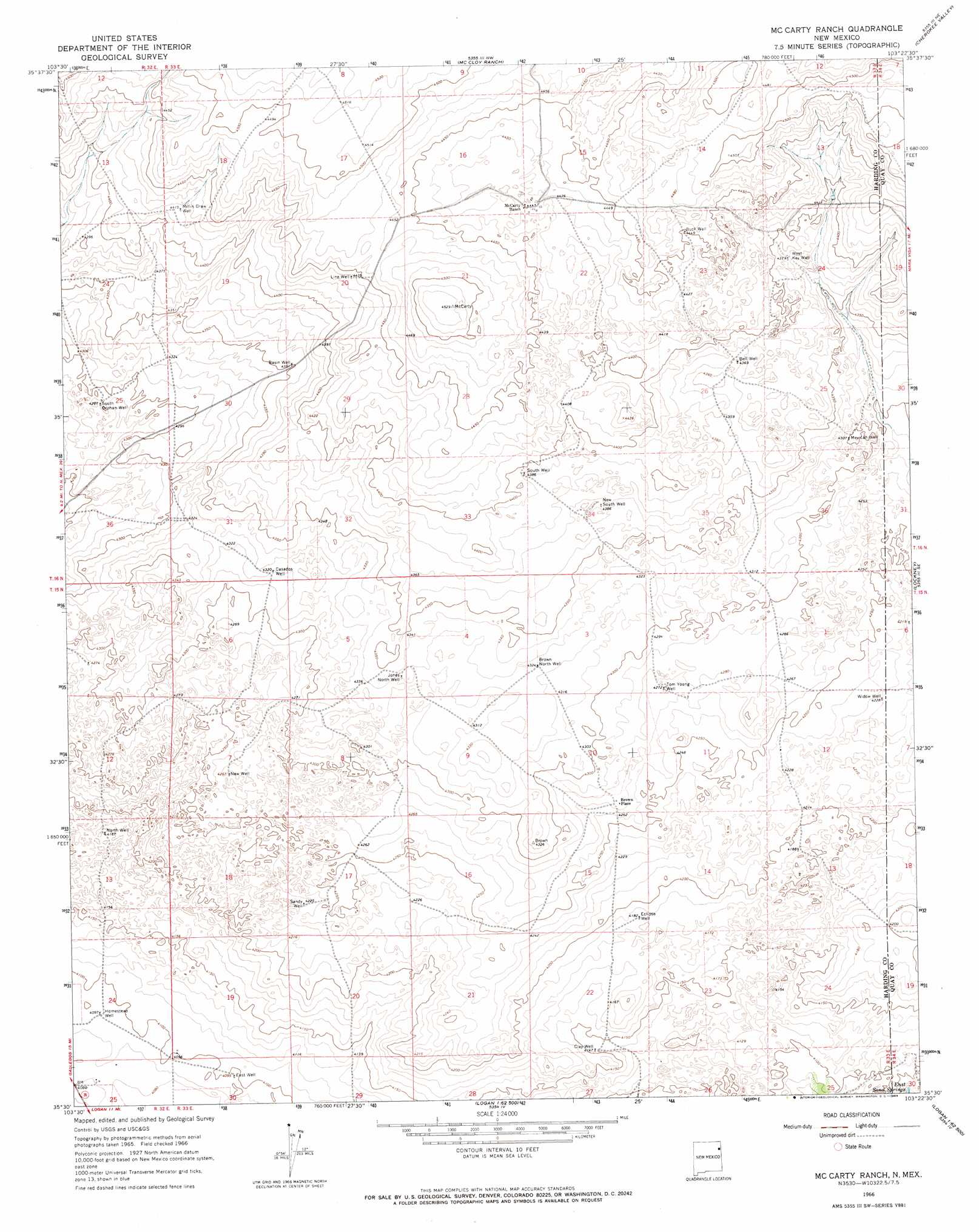
USGS Topo Quad 35103e4 - 1:24,000 scale
| Topo Map Name: | Mccarty Ranch |
| USGS Topo Quad ID: | 35103e4 |
| Print Size: | ca. 21 1/4" wide x 27" high |
| Southeast Coordinates: | 35.5° N latitude / 103.375° W longitude |
| Map Center Coordinates: | 35.5625° N latitude / 103.4375° W longitude |
| U.S. State: | NM |
| Filename: | o35103e4.jpg |
| Download Map JPG Image: | Mccarty Ranch topo map 1:24,000 scale |
| Map Type: | Topographic |
| Topo Series: | 7.5´ |
| Map Scale: | 1:24,000 |
| Source of Map Images: | United States Geological Survey (USGS) |
| Alternate Map Versions: |
Mc Carty Ranch NM 1966, updated 1969 Download PDF Buy paper map McCarty Ranch NM 2010 Download PDF Buy paper map McCarty Ranch NM 2013 Download PDF Buy paper map McCarty Ranch NM 2017 Download PDF Buy paper map |
1:24,000 Topo Quads surrounding Mccarty Ranch
Circle Bar Ranch |
Indian Bathtub |
Rosebud |
Ione |
Centerville Corner |
Buffalo Springs |
Gallegos Ne |
Mccloy Ranch |
Cherokee Valley |
Kerlin Hill |
Gallegos |
Fuentes Ranch |
Mccarty Ranch |
Lockney |
Obar |
Hampton Ranch |
Montesito Creek |
Logan North |
Logan Ne |
Cammak Camp |
Bascom Camp |
Hudson |
Logan South |
Tuscocoillo Canyon |
Blue Hole |
> Back to 35103e1 at 1:100,000 scale
> Back to 35102a1 at 1:250,000 scale
> Back to U.S. Topo Maps home
Mccarty Ranch topo map: Gazetteer
Mccarty Ranch: Populated Places
Brown Place elevation 1303m 4274′Mccarty Ranch: Springs
East Sand Springs elevation 1246m 4087′Mccarty Ranch: Wells
05288 Water Well elevation 1351m 4432′Basin Well elevation 1326m 4350′
Bell Well elevation 1332m 4370′
Brown North Well elevation 1319m 4327′
Buck Well elevation 1357m 4452′
Casados Well elevation 1317m 4320′
Clay Well elevation 1265m 4150′
East Well elevation 1250m 4101′
Eclipse Well elevation 1276m 4186′
Homestead Well elevation 1249m 4097′
Jones North Well elevation 1321m 4333′
Line Well elevation 1353m 4438′
Mexican Well elevation 1311m 4301′
Millin Draw Well elevation 1347m 4419′
Mullin Well elevation 1298m 4258′
New South Well elevation 1332m 4370′
New Well elevation 1302m 4271′
North Well elevation 1271m 4169′
Sandy Well elevation 1290m 4232′
South Orphan Well elevation 1308m 4291′
South Well elevation 1338m 4389′
Tom Young Well elevation 1302m 4271′
West Key Well elevation 1335m 4379′
Widow Well elevation 1289m 4229′
Mccarty Ranch digital topo map on disk
Buy this Mccarty Ranch topo map showing relief, roads, GPS coordinates and other geographical features, as a high-resolution digital map file on DVD: