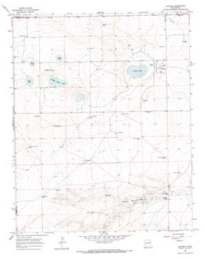
Hayden Topo Map New Mexico
To zoom in, hover over the map of Hayden
USGS Topo Quad 35103h3 - 1:24,000 scale
| Topo Map Name: | Hayden |
| USGS Topo Quad ID: | 35103h3 |
| Print Size: | ca. 21 1/4" wide x 27" high |
| Southeast Coordinates: | 35.875° N latitude / 103.25° W longitude |
| Map Center Coordinates: | 35.9375° N latitude / 103.3125° W longitude |
| U.S. State: | NM |
| Filename: | o35103h3.jpg |
| Download Map JPG Image: | Hayden topo map 1:24,000 scale |
| Map Type: | Topographic |
| Topo Series: | 7.5´ |
| Map Scale: | 1:24,000 |
| Source of Map Images: | United States Geological Survey (USGS) |
| Alternate Map Versions: |
Hayden NM 1966, updated 1968 Download PDF Buy paper map Hayden NM 2010 Download PDF Buy paper map Hayden NM 2013 Download PDF Buy paper map Hayden NM 2017 Download PDF Buy paper map |
1:24,000 Topo Quads surrounding Hayden
> Back to 35103e1 at 1:100,000 scale
> Back to 35102a1 at 1:250,000 scale
> Back to U.S. Topo Maps home
Hayden topo map: Gazetteer
Hayden: Dams
Claude Hutcherson Number 1 Dam elevation 1433m 4701′Claude Hutcherson Number 2 Dam elevation 1450m 4757′
Claude Hutcherson Number 3 Dam elevation 1424m 4671′
Claude Hutcherson Number 4 Dam elevation 1422m 4665′
Claude Hutcherson Number 5 Dam elevation 1463m 4799′
Hayden: Lakes
Antelope Spring Lake elevation 1446m 4744′Horse Lake elevation 1465m 4806′
Lowry Lake elevation 1422m 4665′
Morris Lake elevation 1468m 4816′
Shields Lake elevation 1456m 4776′
Hayden: Populated Places
Hayden elevation 1434m 4704′Hayden: Post Offices
Hayden Post Office (historical) elevation 1434m 4704′Hayden: Reservoirs
Claude Hutcherson Number 1 Reservoir elevation 1433m 4701′Claude Hutcherson Number 5 Reservoir elevation 1463m 4799′
Claude Hutcherson Number Four Reservoir elevation 1422m 4665′
Claude Hutcherson Number Three Reservoir elevation 1424m 4671′
Claude Hutcherson Number Two Reservoir elevation 1450m 4757′
Hayden: Springs
Antelope Spring elevation 1453m 4767′Hayden: Wells
Bates Well elevation 1470m 4822′Bell Well elevation 1504m 4934′
Brown Well elevation 1446m 4744′
Cushman Well elevation 1459m 4786′
Dickson Well elevation 1476m 4842′
Draw Well elevation 1416m 4645′
Dubois Well elevation 1432m 4698′
East Bates Well elevation 1481m 4858′
East Garden Well elevation 1429m 4688′
Garden Well elevation 1440m 4724′
Golf Well elevation 1468m 4816′
Haltaman Well elevation 1456m 4776′
Jake Well elevation 1471m 4826′
Jueschke Well elevation 1452m 4763′
Morris Well elevation 1475m 4839′
Northwest Hobart Well elevation 1509m 4950′
Parmer Well elevation 1445m 4740′
Patman Well elevation 1433m 4701′
Reed Well elevation 1433m 4701′
School Section Well elevation 1442m 4730′
South Morris Well elevation 1500m 4921′
Spring Well elevation 1450m 4757′
Thompson Well elevation 1472m 4829′
Hayden digital topo map on disk
Buy this Hayden topo map showing relief, roads, GPS coordinates and other geographical features, as a high-resolution digital map file on DVD:


