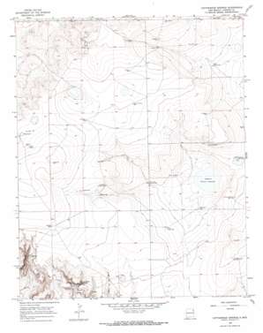
Cottonwood Springs Topo Map New Mexico
To zoom in, hover over the map of Cottonwood Springs
USGS Topo Quad 35103h4 - 1:24,000 scale
| Topo Map Name: | Cottonwood Springs |
| USGS Topo Quad ID: | 35103h4 |
| Print Size: | ca. 21 1/4" wide x 27" high |
| Southeast Coordinates: | 35.875° N latitude / 103.375° W longitude |
| Map Center Coordinates: | 35.9375° N latitude / 103.4375° W longitude |
| U.S. State: | NM |
| Filename: | o35103h4.jpg |
| Download Map JPG Image: | Cottonwood Springs topo map 1:24,000 scale |
| Map Type: | Topographic |
| Topo Series: | 7.5´ |
| Map Scale: | 1:24,000 |
| Source of Map Images: | United States Geological Survey (USGS) |
| Alternate Map Versions: |
Cottonwood Springs NM 1966, updated 1969 Download PDF Buy paper map Cottonwood Springs NM 2010 Download PDF Buy paper map Cottonwood Springs NM 2013 Download PDF Buy paper map Cottonwood Springs NM 2017 Download PDF Buy paper map |
1:24,000 Topo Quads surrounding Cottonwood Springs
> Back to 35103e1 at 1:100,000 scale
> Back to 35102a1 at 1:250,000 scale
> Back to U.S. Topo Maps home
Cottonwood Springs topo map: Gazetteer
Cottonwood Springs: Lakes
Cone Lake elevation 1540m 5052′Laguna Tierra Amatosa elevation 1480m 4855′
Cottonwood Springs: Mines
Amoco Number One State E N elevation 1518m 4980′Cottonwood Springs: Reservoirs
Bobby Lake elevation 1519m 4983′Cottonwood Springs: Springs
Cottonwood Springs elevation 1487m 4878′Cottonwood Springs: Wells
Big West Central Well elevation 1523m 4996′Chaffee Well elevation 1538m 5045′
Crane Well elevation 1494m 4901′
East Well elevation 1539m 5049′
East West Central Well elevation 1495m 4904′
Ells Well elevation 1519m 4983′
Grover Well elevation 1503m 4931′
Hemphill Well elevation 1513m 4963′
Mosier Well elevation 1481m 4858′
North Jackard Well elevation 1492m 4895′
North School Section Well elevation 1495m 4904′
Northwest Holbert Well elevation 1519m 4983′
Northwest Well elevation 1533m 5029′
Old Swoyer Well elevation 1517m 4977′
Red Well elevation 1486m 4875′
Scales Well elevation 1488m 4881′
School Section Well elevation 1534m 5032′
School Section Well elevation 1502m 4927′
Sidenor Well elevation 1531m 5022′
South Scales Well elevation 1500m 4921′
South School Section Well elevation 1508m 4947′
Vaughtrin Well elevation 1527m 5009′
Zahn Well elevation 1511m 4957′
Cottonwood Springs digital topo map on disk
Buy this Cottonwood Springs topo map showing relief, roads, GPS coordinates and other geographical features, as a high-resolution digital map file on DVD:


