Sabinoso Topo Map New Mexico
To zoom in, hover over the map of Sabinoso
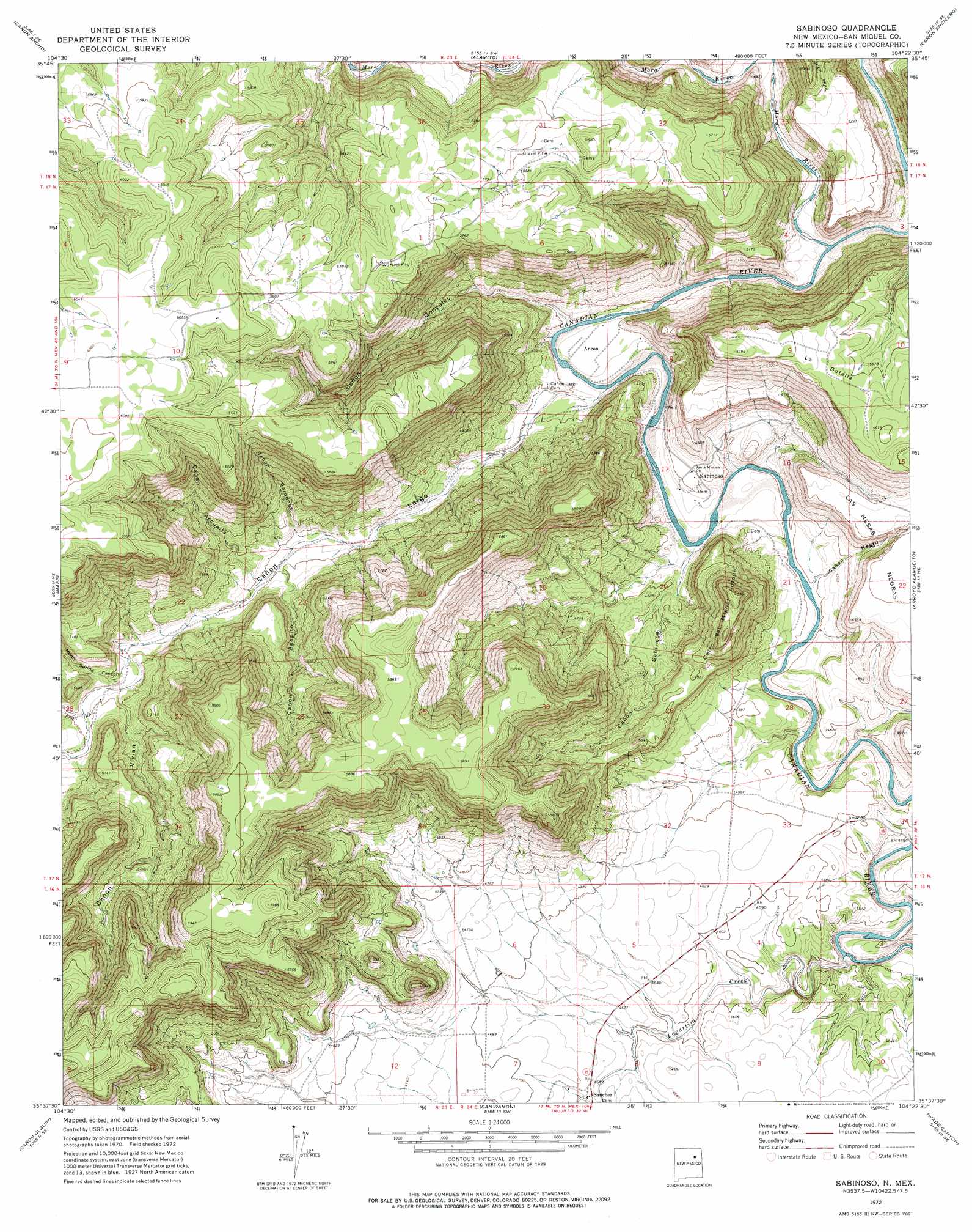
USGS Topo Quad 35104f4 - 1:24,000 scale
| Topo Map Name: | Sabinoso |
| USGS Topo Quad ID: | 35104f4 |
| Print Size: | ca. 21 1/4" wide x 27" high |
| Southeast Coordinates: | 35.625° N latitude / 104.375° W longitude |
| Map Center Coordinates: | 35.6875° N latitude / 104.4375° W longitude |
| U.S. State: | NM |
| Filename: | o35104f4.jpg |
| Download Map JPG Image: | Sabinoso topo map 1:24,000 scale |
| Map Type: | Topographic |
| Topo Series: | 7.5´ |
| Map Scale: | 1:24,000 |
| Source of Map Images: | United States Geological Survey (USGS) |
| Alternate Map Versions: |
Sabinoso NM 1972, updated 1975 Download PDF Buy paper map Sabinoso NM 2010 Download PDF Buy paper map Sabinoso NM 2013 Download PDF Buy paper map Sabinoso NM 2017 Download PDF Buy paper map |
1:24,000 Topo Quads surrounding Sabinoso
Mogote Hills |
Alamosa Creek |
Canon Las Cuevas |
Beaver Canyon |
Roy |
Frutosa Lake |
Canon Ancho |
Alamito |
Canon Encierro |
La Cinta Canyon |
Llonidas Lake |
Maes |
Sabinoso |
Arroyo Alamocito |
Montoya Point |
Trujillo |
Canon Olguin |
San Ramon |
Wade Canyon |
Minese Mesa |
Punta Del Chorro |
Cerro De Corazon |
Variadero |
Four V Ranch |
Conchas Dam |
> Back to 35104e1 at 1:100,000 scale
> Back to 35104a1 at 1:250,000 scale
> Back to U.S. Topo Maps home
Sabinoso topo map: Gazetteer
Sabinoso: Flats
La Botella elevation 1725m 5659′Sabinoso: Mines
Bish Number Two Mine elevation 1713m 5620′Cip Lujan elevation 1388m 4553′
Hunt Oil Company Mine elevation 1486m 4875′
Key Claims elevation 1782m 5846′
Lesters Cabin elevation 1612m 5288′
Lujan Cattle Company elevation 1399m 4589′
Lujan Ranch elevation 1402m 4599′
Mikie V Claims elevation 1625m 5331′
SAB Mine elevation 1486m 4875′
T Claims elevation 1734m 5688′
Verde Mine elevation 1404m 4606′
Windy Number Nine Mine elevation 1577m 5173′
Sabinoso: Parks
Sabinoso Wilderness Study Area elevation 1524m 5000′Sabinoso: Populated Places
Ancon elevation 1398m 4586′Sabinoso elevation 1403m 4603′
Sanchez elevation 1420m 4658′
Sabinoso: Post Offices
Sabinoso Post Office (historical) elevation 1403m 4603′Sanchez Post Office (historical) elevation 1420m 4658′
Sabinoso: Streams
Lagartija Creek elevation 1345m 4412′Mora River elevation 1409m 4622′
Sabinoso: Summits
Cerro del Miguel Antonio elevation 1670m 5479′Sabinoso: Valleys
Cañon Agapito elevation 1434m 4704′Cañon Arguella elevation 1439m 4721′
Cañon Gardunos elevation 1432m 4698′
Cañon Gonzales elevation 1401m 4596′
Cañon Julian elevation 1458m 4783′
Cañon Largo elevation 1397m 4583′
Cañon Negro elevation 1372m 4501′
Cañon Sabinoso elevation 1378m 4520′
Cañon Vivian elevation 1453m 4767′
North Spring Canyon elevation 1451m 4760′
Sabinoso digital topo map on disk
Buy this Sabinoso topo map showing relief, roads, GPS coordinates and other geographical features, as a high-resolution digital map file on DVD: