Jacinto Mesa Topo Map New Mexico
To zoom in, hover over the map of Jacinto Mesa
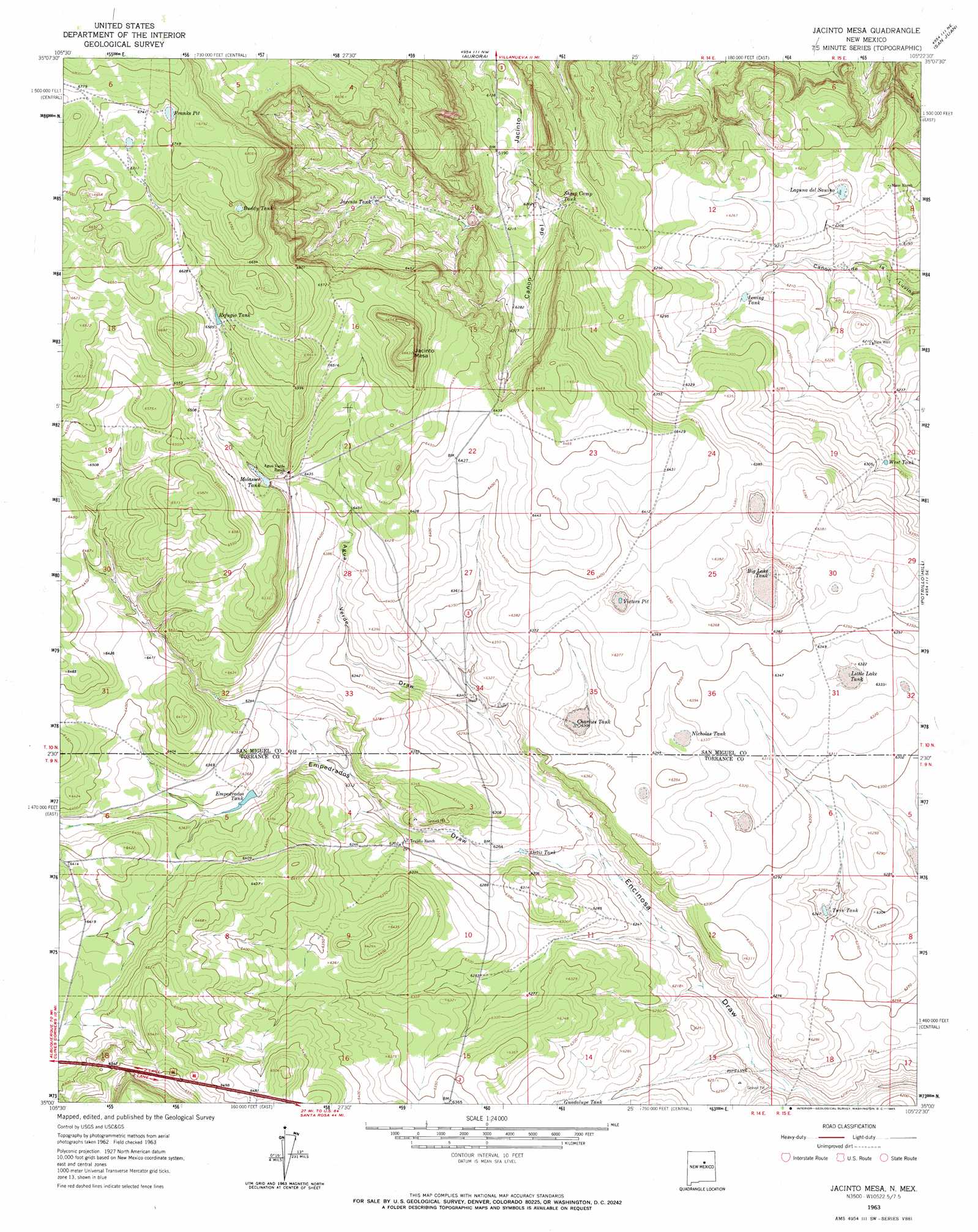
USGS Topo Quad 35105a4 - 1:24,000 scale
| Topo Map Name: | Jacinto Mesa |
| USGS Topo Quad ID: | 35105a4 |
| Print Size: | ca. 21 1/4" wide x 27" high |
| Southeast Coordinates: | 35° N latitude / 105.375° W longitude |
| Map Center Coordinates: | 35.0625° N latitude / 105.4375° W longitude |
| U.S. State: | NM |
| Filename: | o35105a4.jpg |
| Download Map JPG Image: | Jacinto Mesa topo map 1:24,000 scale |
| Map Type: | Topographic |
| Topo Series: | 7.5´ |
| Map Scale: | 1:24,000 |
| Source of Map Images: | United States Geological Survey (USGS) |
| Alternate Map Versions: |
Jacinto Mesa NM 1963, updated 1965 Download PDF Buy paper map Jacinto Mesa NM 2010 Download PDF Buy paper map Jacinto Mesa NM 2013 Download PDF Buy paper map Jacinto Mesa NM 2017 Download PDF Buy paper map |
1:24,000 Topo Quads surrounding Jacinto Mesa
Rencona |
Laguna Ortiz |
Sena |
Villanueva |
Apache Springs |
Mesa El Toro |
Leyba |
Aurora |
San Juan |
Anton Chico |
Clines Corners |
El Cabo |
Jacinto Mesa |
Potrillo Hill |
Mesa Palo Amarillo |
Rock Lake |
Waller Ranch |
Palma |
Milagro Spring |
Milagro |
Pedernal Mountain |
North Lucy |
Santo Nino Canyon |
Pinavete Canyon |
George Ranch |
> Back to 35105a1 at 1:100,000 scale
> Back to 35104a1 at 1:250,000 scale
> Back to U.S. Topo Maps home
Jacinto Mesa topo map: Gazetteer
Jacinto Mesa: Lakes
Victors Pit elevation 1935m 6348′Jacinto Mesa: Reservoirs
Big Lake Tank elevation 1923m 6309′Buddy Tank elevation 2051m 6729′
Charlies Tank elevation 1924m 6312′
Empedrados Tank elevation 1930m 6332′
Franks Pit elevation 2055m 6742′
Guadalupe Tank elevation 1909m 6263′
Laguna del Sauino elevation 1890m 6200′
Little Lake Tank elevation 1925m 6315′
Loving Tank elevation 1897m 6223′
Mesita Tank elevation 1873m 6145′
Molasses Tank elevation 1967m 6453′
Nicholas Tank elevation 1928m 6325′
Ortiz Tank elevation 1908m 6259′
Refugio Tank elevation 2004m 6574′
Sheep Camp Tank elevation 1901m 6236′
Twin Tank elevation 1906m 6253′
West Tank elevation 1915m 6282′
Jacinto Mesa: Summits
Jacinto Mesa elevation 2032m 6666′Jacinto Mesa: Valleys
Agua Verde Draw elevation 1915m 6282′Empedrados Draw elevation 1902m 6240′
Encinoso Draw elevation 1915m 6282′
Jacinto Mesa: Wells
New Well elevation 1894m 6213′Jacinto Mesa digital topo map on disk
Buy this Jacinto Mesa topo map showing relief, roads, GPS coordinates and other geographical features, as a high-resolution digital map file on DVD: