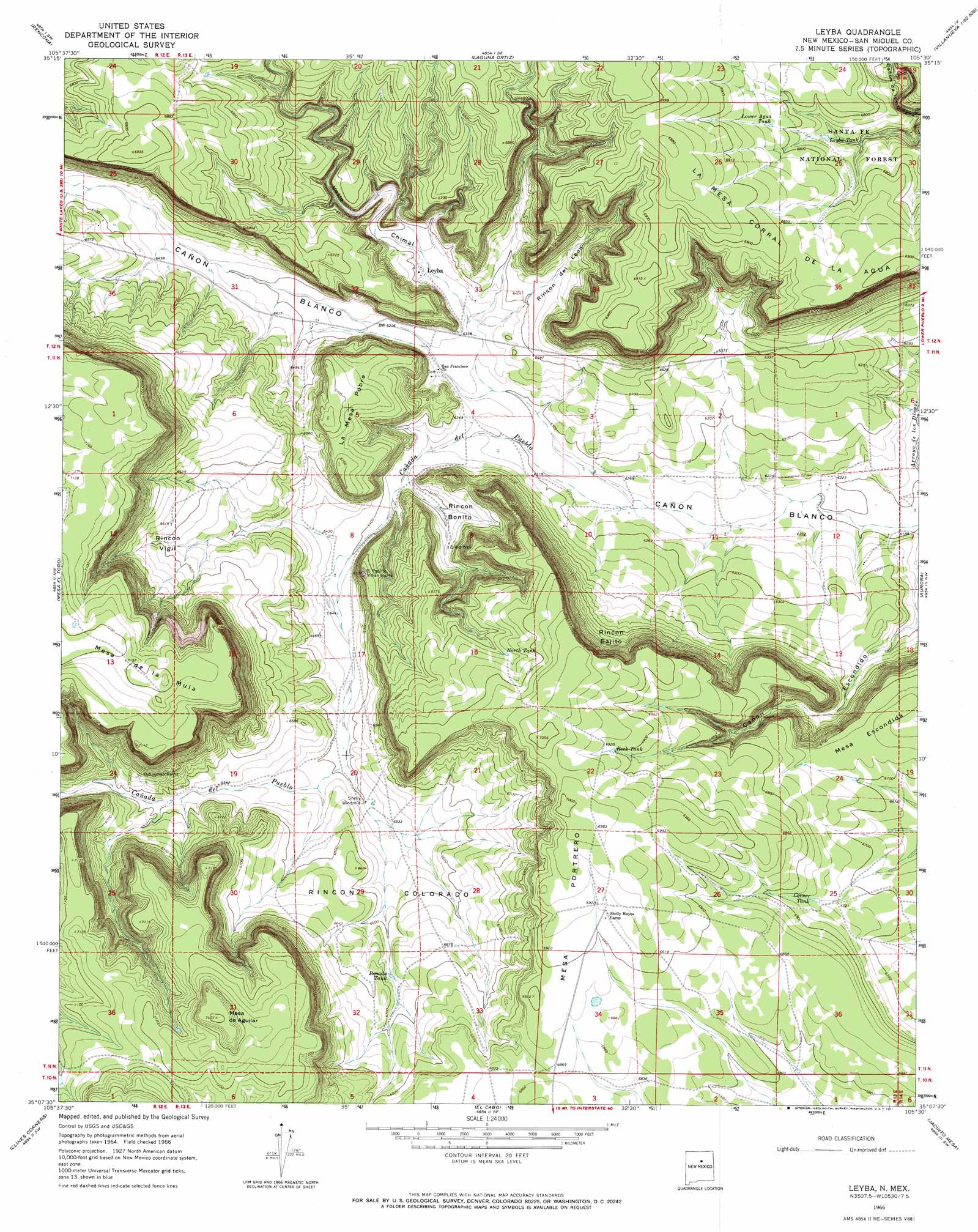
Leyba Topo Map New Mexico
To zoom in, hover over the map of Leyba
USGS Topo Quad 35105b5 - 1:24,000 scale
| Topo Map Name: | Leyba |
| USGS Topo Quad ID: | 35105b5 |
| Print Size: | ca. 21 1/4" wide x 27" high |
| Southeast Coordinates: | 35.125° N latitude / 105.5° W longitude |
| Map Center Coordinates: | 35.1875° N latitude / 105.5625° W longitude |
| U.S. State: | NM |
| Filename: | o35105b5.jpg |
| Download Map JPG Image: | Leyba topo map 1:24,000 scale |
| Map Type: | Topographic |
| Topo Series: | 7.5´ |
| Map Scale: | 1:24,000 |
| Source of Map Images: | United States Geological Survey (USGS) |
| Alternate Map Versions: |
Leyba NM 1966, updated 1971 Download PDF Buy paper map Leyba NM 2002, updated 2003 Download PDF Buy paper map Leyba NM 2011 Download PDF Buy paper map Leyba NM 2013 Download PDF Buy paper map Leyba NM 2017 Download PDF Buy paper map |
| FStopo: | US Forest Service topo Leyba is available: Download FStopo PDF Download FStopo TIF |
1:24,000 Topo Quads surrounding Leyba
Bull Canyon |
Rowe |
North San Ysidro |
San Jose |
Tecolote |
Wildhorse Mesa |
Rencona |
Laguna Ortiz |
Sena |
Villanueva |
White |
Mesa El Toro |
Leyba |
Aurora |
San Juan |
El Cuervo Butte |
Clines Corners |
El Cabo |
Jacinto Mesa |
Potrillo Hill |
Lobo Hill Ne |
Rock Lake |
Waller Ranch |
Palma |
Milagro Spring |
> Back to 35105a1 at 1:100,000 scale
> Back to 35104a1 at 1:250,000 scale
> Back to U.S. Topo Maps home
Leyba topo map: Gazetteer
Leyba: Areas
Rincon Bajito elevation 2020m 6627′Rincon Bonito elevation 1952m 6404′
Rincon Colorado elevation 2005m 6578′
Rincon Vigil elevation 2002m 6568′
Leyba: Post Offices
Leyba Post Office elevation 1948m 6391′Leyba: Reservoirs
Benada Tank elevation 2027m 6650′Corner Tank elevation 2056m 6745′
Leyba Tank elevation 2050m 6725′
Lower Agua Tank elevation 2079m 6820′
Lower Aqua Tank elevation 2019m 6624′
North Tank elevation 2079m 6820′
Rock Tank elevation 2106m 6909′
Leyba: Streams
Cañada de Pueblo elevation 1905m 6250′Leyba: Summits
La Mesa Corral de la Agua elevation 2130m 6988′La Mesa Pobre elevation 2055m 6742′
Mesa de Aguilar elevation 2258m 7408′
Mesa de la Mula elevation 2202m 7224′
Mesa Escondida elevation 2052m 6732′
Mesa Portrero elevation 2135m 7004′
Leyba: Valleys
Rincon del Leon elevation 1934m 6345′Valle Chimal elevation 1938m 6358′
Leyba: Wells
Blind Well elevation 1966m 6450′Leyba digital topo map on disk
Buy this Leyba topo map showing relief, roads, GPS coordinates and other geographical features, as a high-resolution digital map file on DVD: