Sena Topo Map New Mexico
To zoom in, hover over the map of Sena
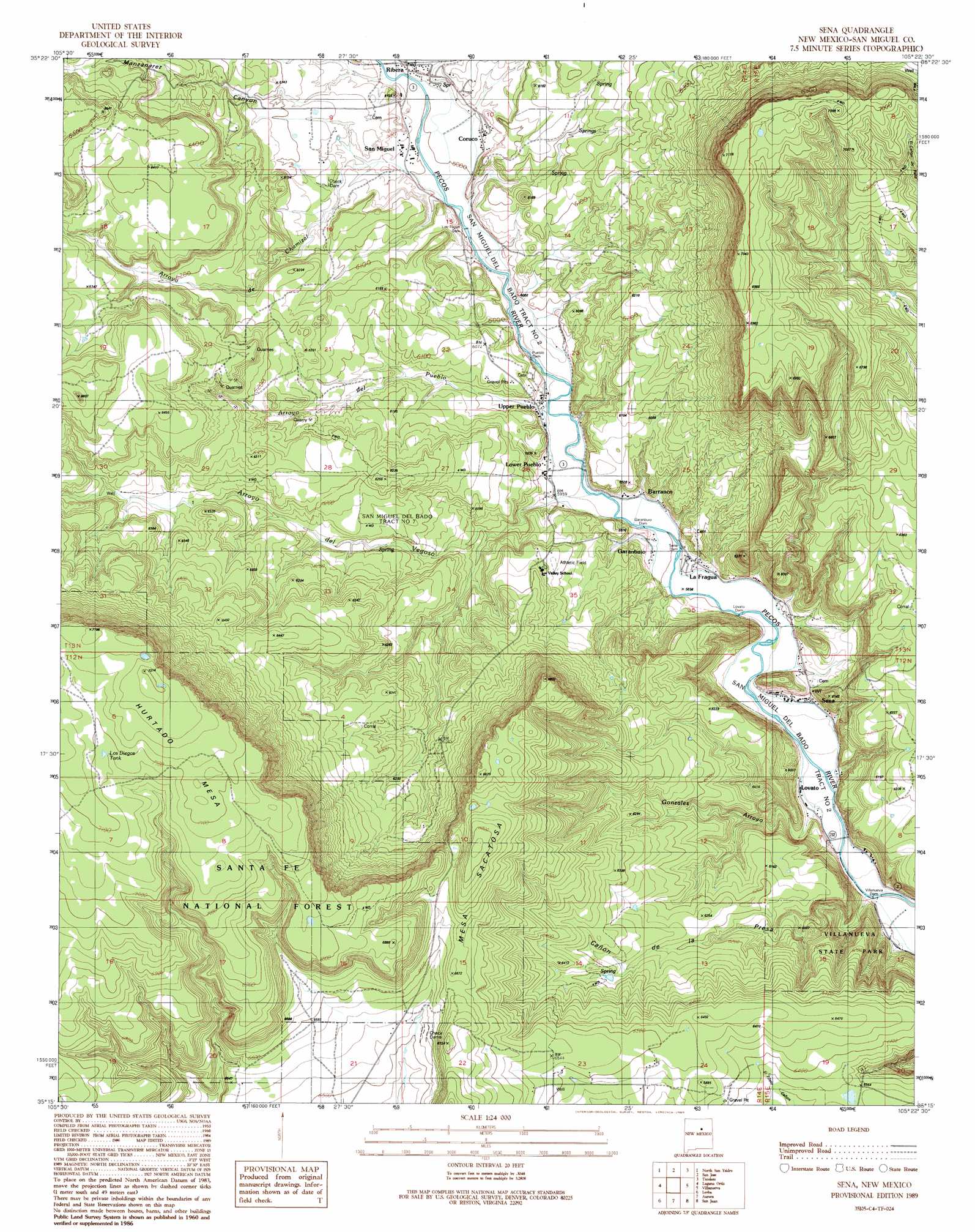
USGS Topo Quad 35105c4 - 1:24,000 scale
| Topo Map Name: | Sena |
| USGS Topo Quad ID: | 35105c4 |
| Print Size: | ca. 21 1/4" wide x 27" high |
| Southeast Coordinates: | 35.25° N latitude / 105.375° W longitude |
| Map Center Coordinates: | 35.3125° N latitude / 105.4375° W longitude |
| U.S. State: | NM |
| Filename: | o35105c4.jpg |
| Download Map JPG Image: | Sena topo map 1:24,000 scale |
| Map Type: | Topographic |
| Topo Series: | 7.5´ |
| Map Scale: | 1:24,000 |
| Source of Map Images: | United States Geological Survey (USGS) |
| Alternate Map Versions: |
Sena NM 1989, updated 1989 Download PDF Buy paper map Sena NM 2002, updated 2003 Download PDF Buy paper map Sena NM 2011 Download PDF Buy paper map Sena NM 2013 Download PDF Buy paper map Sena NM 2017 Download PDF Buy paper map |
| FStopo: | US Forest Service topo Sena is available: Download FStopo PDF Download FStopo TIF |
1:24,000 Topo Quads surrounding Sena
Pecos |
Lower Colonias |
San Geronimo |
Ojitos Frios |
Las Vegas |
Rowe |
North San Ysidro |
San Jose |
Tecolote |
Los Montoyas |
Rencona |
Laguna Ortiz |
Sena |
Villanueva |
Apache Springs |
Mesa El Toro |
Leyba |
Aurora |
San Juan |
Anton Chico |
Clines Corners |
El Cabo |
Jacinto Mesa |
Potrillo Hill |
Mesa Palo Amarillo |
> Back to 35105a1 at 1:100,000 scale
> Back to 35104a1 at 1:250,000 scale
> Back to U.S. Topo Maps home
Sena topo map: Gazetteer
Sena: Canals
Los Trigos Ditch elevation 1827m 5994′Lovato Ditch elevation 1791m 5875′
Pueblo Ditch elevation 1812m 5944′
Ribera Ditch elevation 1833m 6013′
Sena Ditch elevation 1797m 5895′
Sena: Dams
Garanbuio Dam elevation 1800m 5905′Los Trigos Dam elevation 1827m 5994′
Lovato Dam elevation 1793m 5882′
Pueblo Dam elevation 1811m 5941′
Sena Dam elevation 1799m 5902′
Villanueva Dam elevation 1770m 5807′
Sena: Populated Places
Barranco elevation 1815m 5954′Coruco elevation 1837m 6026′
Garanbuio elevation 1802m 5912′
La Fragua elevation 1806m 5925′
Lovato elevation 1782m 5846′
Lower Pueblo elevation 1815m 5954′
Ribera elevation 1845m 6053′
San Miguel elevation 1836m 6023′
Sena elevation 1791m 5875′
Upper Pueblo elevation 1815m 5954′
Sena: Post Offices
Ribera Post Office elevation 1845m 6053′San Miguel Post Office (historical) elevation 1836m 6023′
Sedan Post Office elevation 1791m 5875′
Sena: Reservoirs
Los Diegos elevation 2159m 7083′Sena: Streams
Arroyo de Chamizal elevation 1827m 5994′Sena: Valleys
Arroyo del Pueblo elevation 1815m 5954′Arroyo Vegoso elevation 1803m 5915′
Cañon de la Presta elevation 1770m 5807′
Gonzales Arroyo elevation 1782m 5846′
Manzanarez Canyon elevation 1868m 6128′
Sena: Wells
Flowing Well elevation 1842m 6043′Sena digital topo map on disk
Buy this Sena topo map showing relief, roads, GPS coordinates and other geographical features, as a high-resolution digital map file on DVD: