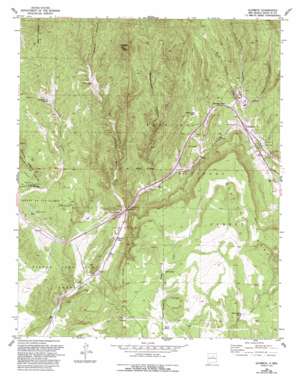
Glorieta Topo Map New Mexico
To zoom in, hover over the map of Glorieta
USGS Topo Quad 35105e7 - 1:24,000 scale
| Topo Map Name: | Glorieta |
| USGS Topo Quad ID: | 35105e7 |
| Print Size: | ca. 21 1/4" wide x 27" high |
| Southeast Coordinates: | 35.5° N latitude / 105.75° W longitude |
| Map Center Coordinates: | 35.5625° N latitude / 105.8125° W longitude |
| U.S. State: | NM |
| Filename: | o35105e7.jpg |
| Download Map JPG Image: | Glorieta topo map 1:24,000 scale |
| Map Type: | Topographic |
| Topo Series: | 7.5´ |
| Map Scale: | 1:24,000 |
| Source of Map Images: | United States Geological Survey (USGS) |
| Alternate Map Versions: |
Glorieta NM 1953, updated 1955 Download PDF Buy paper map Glorieta NM 1953, updated 1959 Download PDF Buy paper map Glorieta NM 1953, updated 1977 Download PDF Buy paper map Glorieta NM 1953, updated 1979 Download PDF Buy paper map Glorieta NM 1953, updated 1983 Download PDF Buy paper map Glorieta NM 1953, updated 1993 Download PDF Buy paper map Glorieta NM 2002, updated 2003 Download PDF Buy paper map Glorieta NM 2011 Download PDF Buy paper map Glorieta NM 2013 Download PDF Buy paper map Glorieta NM 2017 Download PDF Buy paper map |
| FStopo: | US Forest Service topo Glorieta is available: Download FStopo PDF Download FStopo TIF |
1:24,000 Topo Quads surrounding Glorieta
> Back to 35105e1 at 1:100,000 scale
> Back to 35104a1 at 1:250,000 scale
> Back to U.S. Topo Maps home
Glorieta topo map: Gazetteer
Glorieta: Crossings
294 Cañoncito Interchange elevation 2134m 7001′297 Valencia Interchange elevation 2251m 7385′
299 Glorieta Interchange elevation 2263m 7424′
Glorieta: Gaps
Glorieta Pass elevation 2304m 7559′Glorieta: Mines
Kunklin elevation 2468m 8097′Paytiano elevation 2232m 7322′
Glorieta: Parks
DAR Monument elevation 2138m 7014′Glorieta Pass Historical Marker elevation 2304m 7559′
Pecos National Historic Park elevation 2108m 6916′
Santa Fe Trail Historical Marker elevation 2215m 7267′
Glorieta: Populated Places
Cañada de los Alamos elevation 2305m 7562′Glorieta elevation 2265m 7431′
Glorieta: Post Offices
Cañoncito Post Office (historical) elevation 2121m 6958′Glorieta Post Office elevation 2265m 7431′
Glorieta: Streams
Deer Creek elevation 2140m 7020′Hagen Creek elevation 2263m 7424′
Glorieta: Summits
Fangio Mesa elevation 2288m 7506′Shaggy Peak elevation 2653m 8704′
Glorieta: Trails
Deer Trail elevation 0m 0′Santa Fe National Historic Trail elevation 2215m 7267′
Glorieta: Valleys
Apache Canyon elevation 2124m 6968′Glorieta Canyon elevation 2244m 7362′
Grasshopper Canyon elevation 2243m 7358′
Ruiz Canyon elevation 2294m 7526′
Glorieta: Wells
Oldest Well elevation 2206m 7237′Padre Water Well elevation 2267m 7437′
Glorieta digital topo map on disk
Buy this Glorieta topo map showing relief, roads, GPS coordinates and other geographical features, as a high-resolution digital map file on DVD:


