Seton Village Topo Map New Mexico
To zoom in, hover over the map of Seton Village
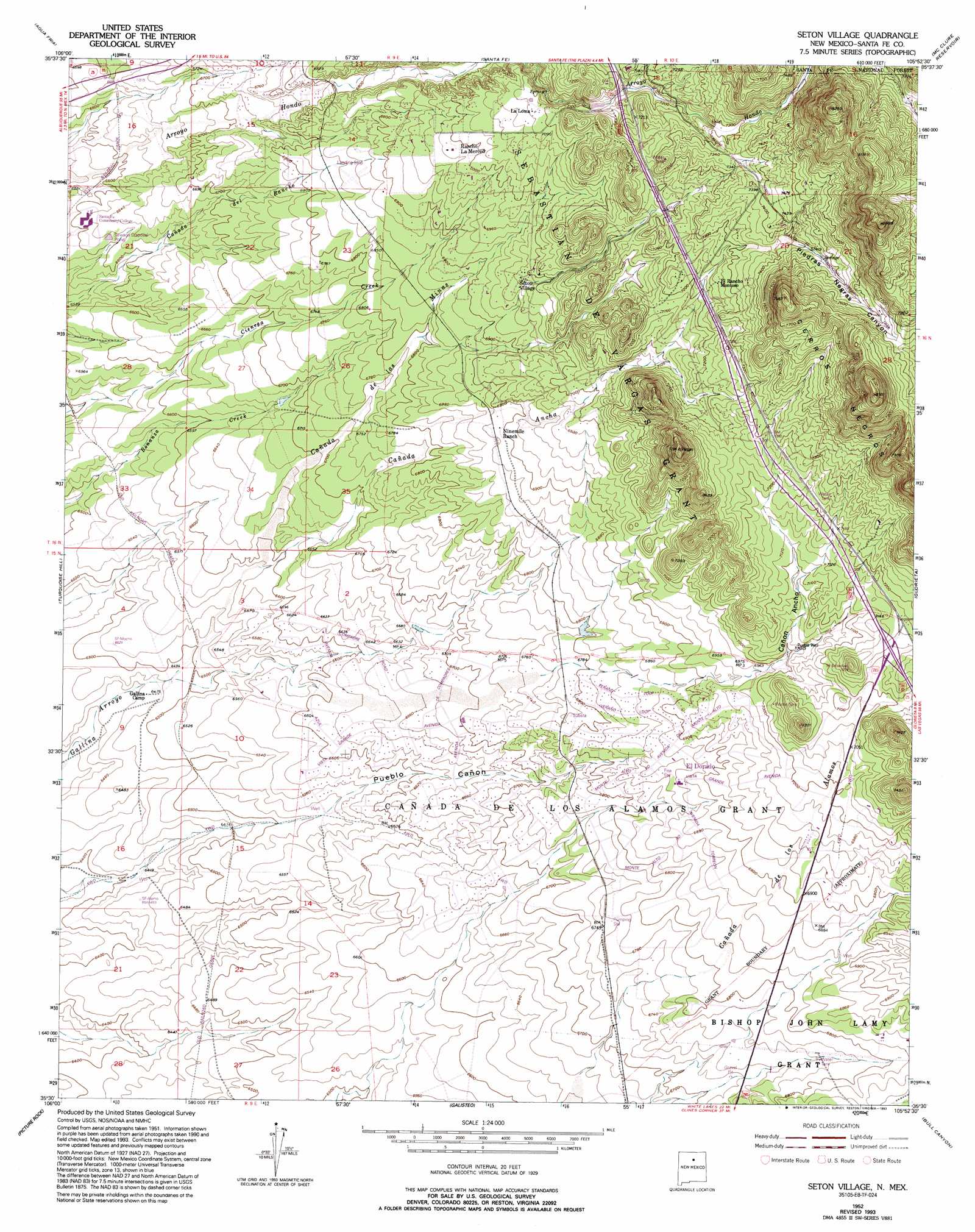
USGS Topo Quad 35105e8 - 1:24,000 scale
| Topo Map Name: | Seton Village |
| USGS Topo Quad ID: | 35105e8 |
| Print Size: | ca. 21 1/4" wide x 27" high |
| Southeast Coordinates: | 35.5° N latitude / 105.875° W longitude |
| Map Center Coordinates: | 35.5625° N latitude / 105.9375° W longitude |
| U.S. State: | NM |
| Filename: | o35105e8.jpg |
| Download Map JPG Image: | Seton Village topo map 1:24,000 scale |
| Map Type: | Topographic |
| Topo Series: | 7.5´ |
| Map Scale: | 1:24,000 |
| Source of Map Images: | United States Geological Survey (USGS) |
| Alternate Map Versions: |
Seton Village NM 1952, updated 1953 Download PDF Buy paper map Seton Village NM 1952, updated 1965 Download PDF Buy paper map Seton Village NM 1952, updated 1973 Download PDF Buy paper map Seton Village NM 1952, updated 1985 Download PDF Buy paper map Seton Village NM 1952, updated 1993 Download PDF Buy paper map Seton Village NM 2002, updated 2003 Download PDF Buy paper map Seton Village NM 2011 Download PDF Buy paper map Seton Village NM 2013 Download PDF Buy paper map Seton Village NM 2017 Download PDF Buy paper map |
| FStopo: | US Forest Service topo Seton Village is available: Download FStopo PDF Download FStopo TIF |
1:24,000 Topo Quads surrounding Seton Village
White Rock |
Horcado Ranch |
Tesuque |
Aspen Basin |
Cowles |
Montoso Peak |
Agua Fria |
Santa Fe |
Mcclure Reservoir |
Rosilla Peak |
Tetilla Peak |
Turquoise Hill |
Seton Village |
Glorieta |
Pecos |
Madrid |
Picture Rock |
Galisteo |
Bull Canyon |
Rowe |
Golden |
Captain Davis Mountain |
Ojo Hedionda |
Wildhorse Mesa |
Rencona |
> Back to 35105e1 at 1:100,000 scale
> Back to 35104a1 at 1:250,000 scale
> Back to U.S. Topo Maps home
Seton Village topo map: Gazetteer
Seton Village: Parks
Santa Fe on the Camino Real elevation 2103m 6899′Seton Village Historical Marker elevation 2132m 6994′
Seton Village: Populated Places
El Dorado elevation 2083m 6833′El Dorado at Santa Fe elevation 2103m 6899′
Eldorado at Santa Fe elevation 2035m 6676′
La Loma elevation 2165m 7103′
Seton Village elevation 2132m 6994′
Seton Village: Post Offices
La Loma Post Office elevation 2167m 7109′Seton Village: Ridges
Cerros Negros elevation 2484m 8149′Seton Village: Valleys
Cañada Ancha elevation 2006m 6581′Cañada de las Minas elevation 2006m 6581′
Canyon Ancho elevation 2126m 6975′
Piedras Negras Canyon elevation 2250m 7381′
Seton Village: Wells
10229 Water Well elevation 2278m 7473′10231 Water Well elevation 2185m 7168′
10259 Water Well elevation 1992m 6535′
Low Vicnty Water Well elevation 1956m 6417′
Lower Vicinity Well elevation 1956m 6417′
Pueblo Well elevation 2139m 7017′
RG-14644 Water Well elevation 2049m 6722′
RG-17862 Water Well elevation 2070m 6791′
RG-18332 Water Well elevation 2068m 6784′
RG-18512 Water Well elevation 2007m 6584′
RG-18513 Water Well elevation 1991m 6532′
RG-18529 Water Well elevation 2042m 6699′
RG-18537 Water Well elevation 2030m 6660′
RG-18559 Water Well elevation 2007m 6584′
RG-18572 Water Well elevation 1991m 6532′
RG-18584 Water Well elevation 2021m 6630′
RG-18585 Water Well elevation 2016m 6614′
RG-18593 Water Well elevation 1999m 6558′
RG-18594 Water Well elevation 1999m 6558′
RG-19632 Water Well elevation 2082m 6830′
RG-23448 Water Well elevation 2075m 6807′
RG-25679 Water Well elevation 2031m 6663′
RG-28307 Water Well elevation 2014m 6607′
RG-8247 Water Well elevation 2065m 6774′
Upper Vicinity Well elevation 1991m 6532′
Seton Village digital topo map on disk
Buy this Seton Village topo map showing relief, roads, GPS coordinates and other geographical features, as a high-resolution digital map file on DVD: