Mora Topo Map New Mexico
To zoom in, hover over the map of Mora
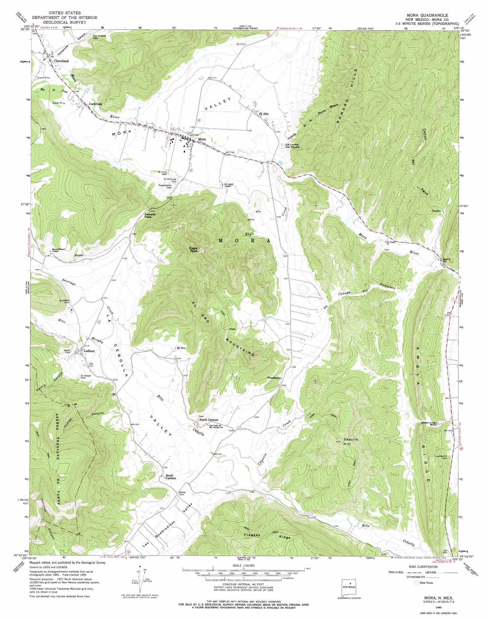
USGS Topo Quad 35105h3 - 1:24,000 scale
| Topo Map Name: | Mora |
| USGS Topo Quad ID: | 35105h3 |
| Print Size: | ca. 21 1/4" wide x 27" high |
| Southeast Coordinates: | 35.875° N latitude / 105.25° W longitude |
| Map Center Coordinates: | 35.9375° N latitude / 105.3125° W longitude |
| U.S. State: | NM |
| Filename: | o35105h3.jpg |
| Download Map JPG Image: | Mora topo map 1:24,000 scale |
| Map Type: | Topographic |
| Topo Series: | 7.5´ |
| Map Scale: | 1:24,000 |
| Source of Map Images: | United States Geological Survey (USGS) |
| Alternate Map Versions: |
Mora NM 1965, updated 1968 Download PDF Buy paper map Mora NM 1965, updated 1978 Download PDF Buy paper map Mora NM 2002, updated 2003 Download PDF Buy paper map Mora NM 2011 Download PDF Buy paper map Mora NM 2013 Download PDF Buy paper map Mora NM 2017 Download PDF Buy paper map |
| FStopo: | US Forest Service topo Mora is available: Download FStopo PDF Download FStopo TIF |
1:24,000 Topo Quads surrounding Mora
Tres Ritos |
Cerro Vista |
Chacon |
Guadalupita |
Ocate |
Jicarita Peak |
Holman |
Comanche Peak |
Lucero |
Ojo Feliz |
Pecos Falls |
Gascon |
Mora |
Rainsville |
Fort Union |
Elk Mountain |
Rociada |
Sapello |
Lake Isabel |
Loma Parda |
Honey Boy Ranch |
El Porvenir |
Montezuma |
Las Vegas Nw |
Onava |
> Back to 35105e1 at 1:100,000 scale
> Back to 35104a1 at 1:250,000 scale
> Back to U.S. Topo Maps home
Mora topo map: Gazetteer
Mora: Areas
Mora Valley elevation 2178m 7145′Mora: Arroyos
Cañada de Agua elevation 2159m 7083′Cañada del Agua elevation 2167m 7109′
Mora: Gaps
Cebolla Pass elevation 2339m 7673′Mora: Mines
Mica Mine elevation 2227m 7306′Mora Beryl Prospect elevation 2320m 7611′
Mora: Populated Places
Abuelo elevation 2310m 7578′Cañon elevation 2305m 7562′
Canoncito elevation 2153m 7063′
Cleveland elevation 2248m 7375′
Cordillera elevation 2227m 7306′
El Alto elevation 2178m 7145′
Ledoux elevation 2279m 7477′
Mora elevation 2186m 7171′
North Carmen elevation 2215m 7267′
Puertocito elevation 2255m 7398′
Santa Gertrudis (historical) elevation 2206m 7237′
South Carmen elevation 2229m 7312′
Mora: Post Offices
Cleveland Post Office elevation 2248m 7375′Ledoux Post Office elevation 2280m 7480′
Mora Post Office elevation 2186m 7171′
Mora: Ranges
Romero Hills elevation 2557m 8389′Mora: Ridges
Amola Ridge elevation 2227m 7306′El Oro Mountains elevation 2319m 7608′
Mora: Streams
Aito del Taico elevation 2228m 7309′Alto De Las Herrera elevation 2225m 7299′
Cañada de la Tierra Blanco elevation 2183m 7162′
Capulin Creek elevation 2184m 7165′
Eagle Creek elevation 2171m 7122′
La Canada del Guajalote elevation 2142m 7027′
Rio la Casa elevation 2222m 7290′
Rito Morphy elevation 2231m 7319′
Santiago Creek elevation 2231m 7319′
Mora: Summits
Capulin Hill elevation 2446m 8024′Eagle Peak elevation 2573m 8441′
El Poso elevation 2514m 8248′
La Loma del Mudo elevation 2196m 7204′
Mora: Valleys
Cañon del Agua elevation 2144m 7034′Comanche Canyon elevation 2243m 7358′
Garcia Canyon elevation 2277m 7470′
La Cebolla Valley elevation 2180m 7152′
Las Quebraditas Valley elevation 2202m 7224′
Los Aguatas Valley elevation 2171m 7122′
Tomas Canyon elevation 2258m 7408′
Mora digital topo map on disk
Buy this Mora topo map showing relief, roads, GPS coordinates and other geographical features, as a high-resolution digital map file on DVD: