Hagan Topo Map New Mexico
To zoom in, hover over the map of Hagan
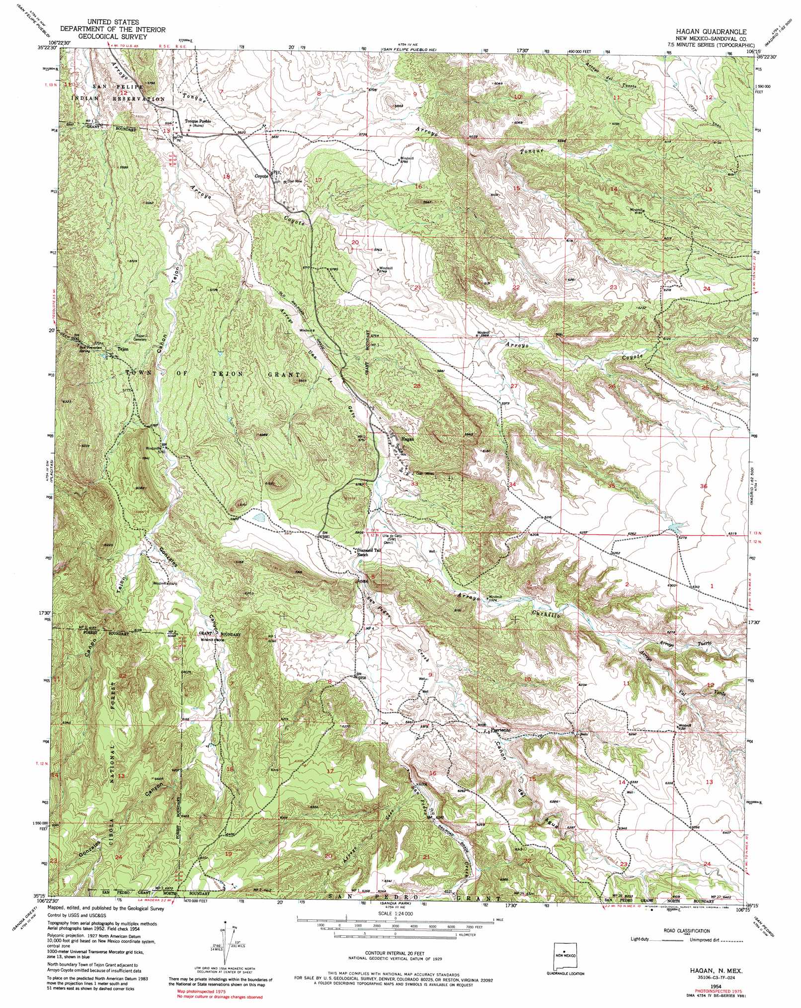
USGS Topo Quad 35106c3 - 1:24,000 scale
| Topo Map Name: | Hagan |
| USGS Topo Quad ID: | 35106c3 |
| Print Size: | ca. 21 1/4" wide x 27" high |
| Southeast Coordinates: | 35.25° N latitude / 106.25° W longitude |
| Map Center Coordinates: | 35.3125° N latitude / 106.3125° W longitude |
| U.S. State: | NM |
| Filename: | o35106c3.jpg |
| Download Map JPG Image: | Hagan topo map 1:24,000 scale |
| Map Type: | Topographic |
| Topo Series: | 7.5´ |
| Map Scale: | 1:24,000 |
| Source of Map Images: | United States Geological Survey (USGS) |
| Alternate Map Versions: |
Hagan NM 1954, updated 1955 Download PDF Buy paper map Hagan NM 1954, updated 1963 Download PDF Buy paper map Hagan NM 1954, updated 1975 Download PDF Buy paper map Hagan NM 1975, updated 1986 Download PDF Buy paper map Hagan NM 1990, updated 1996 Download PDF Buy paper map Hagan NM 2006, updated 2007 Download PDF Buy paper map Hagan NM 2011 Download PDF Buy paper map Hagan NM 2013 Download PDF Buy paper map Hagan NM 2017 Download PDF Buy paper map |
| FStopo: | US Forest Service topo Hagan is available: Download FStopo PDF Download FStopo TIF |
1:24,000 Topo Quads surrounding Hagan
Loma Creston |
Santo Domingo Pueblo Sw |
Santo Domingo Pueblo |
Tetilla Peak |
Turquoise Hill |
Santa Ana Pueblo |
San Felipe Pueblo |
San Felipe Pueblo Ne |
Madrid |
Picture Rock |
Bernalillo |
Placitas |
Hagan |
Golden |
Captain Davis Mountain |
Alameda |
Sandia Crest |
Sandia Park |
San Pedro |
King Draw |
Albuquerque East |
Tijeras |
Sedillo |
Edgewood |
Moriarty North |
> Back to 35106a1 at 1:100,000 scale
> Back to 35106a1 at 1:250,000 scale
> Back to U.S. Topo Maps home
Hagan topo map: Gazetteer
Hagan: Arroyos
Arroyo Coyote elevation 1676m 5498′Arroyo Cuchillo elevation 1762m 5780′
Arroyo Seco elevation 1832m 6010′
Arroyo Tuerto elevation 1852m 6076′
Arroyo Uña de Gato elevation 1695m 5561′
Arroyo Val Verde elevation 1852m 6076′
San Pedro Creek elevation 1762m 5780′
Hagan: Mines
A Placer elevation 1912m 6272′Coyote Mine elevation 1730m 5675′
Crummy Number One Prospect elevation 2006m 6581′
Diamond Tail elevation 1779m 5836′
Diamond Tail Project elevation 1845m 6053′
Donnell Prospect elevation 1719m 5639′
Hagan Mines elevation 1782m 5846′
Mimi Number Four Prospect elevation 1807m 5928′
New Mexico Placer elevation 1919m 6295′
Perini Prospect elevation 1920m 6299′
Sloan Mine elevation 1732m 5682′
Tejon Number Two Mine elevation 1740m 5708′
Uranium Prospect elevation 1766m 5793′
Hagan: Populated Places
Coyote (historical) elevation 1730m 5675′Hagan (historical) elevation 1763m 5784′
Puertecito elevation 1837m 6026′
Tejon (historical) elevation 1767m 5797′
Hagan: Post Offices
Hagan Post Office (historical) elevation 1763m 5784′Hagan: Springs
Escondido Spring elevation 1949m 6394′San Francisco Spring elevation 1806m 5925′
Hagan: Valleys
Cañon del Agua elevation 1806m 5925′Cañon Tejon elevation 1683m 5521′
Gonzales Canyon elevation 1793m 5882′
Hagan digital topo map on disk
Buy this Hagan topo map showing relief, roads, GPS coordinates and other geographical features, as a high-resolution digital map file on DVD: