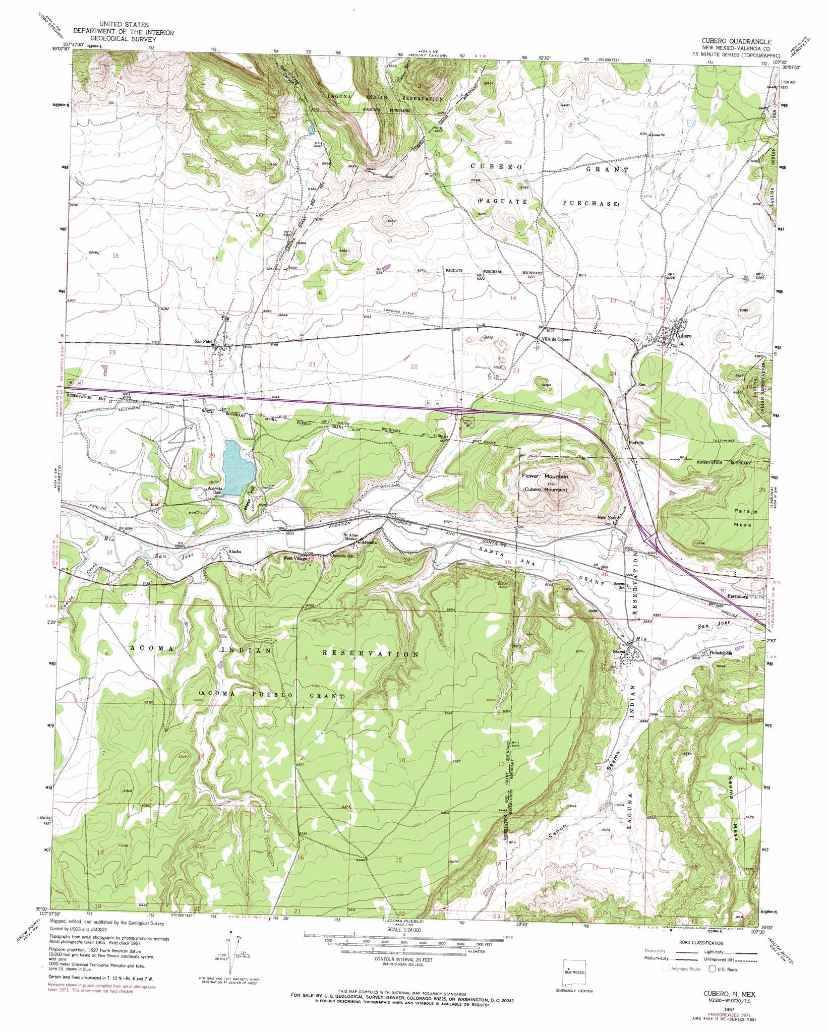
Cubero Topo Map New Mexico
To zoom in, hover over the map of Cubero
USGS Topo Quad 35107a5 - 1:24,000 scale
| Topo Map Name: | Cubero |
| USGS Topo Quad ID: | 35107a5 |
| Print Size: | ca. 21 1/4" wide x 27" high |
| Southeast Coordinates: | 35° N latitude / 107.5° W longitude |
| Map Center Coordinates: | 35.0625° N latitude / 107.5625° W longitude |
| U.S. State: | NM |
| Filename: | o35107a5.jpg |
| Download Map JPG Image: | Cubero topo map 1:24,000 scale |
| Map Type: | Topographic |
| Topo Series: | 7.5´ |
| Map Scale: | 1:24,000 |
| Source of Map Images: | United States Geological Survey (USGS) |
| Alternate Map Versions: |
Cubero NM 1957, updated 1959 Download PDF Buy paper map Cubero NM 1957, updated 1973 Download PDF Buy paper map Cubero NM 2010 Download PDF Buy paper map Cubero NM 2013 Download PDF Buy paper map Cubero NM 2017 Download PDF Buy paper map |
1:24,000 Topo Quads surrounding Cubero
Dos Lomas |
San Mateo |
Cerro Pelon |
Laguna Canoneros |
Marquez |
Grants |
Lobo Springs |
Mount Taylor |
Seboyeta |
Moquino |
Grants Se |
Mccartys |
Cubero |
Laguna |
Mesita |
Los Pilares |
Crow Point |
Acoma Pueblo |
South Butte |
Dough Mountain |
Laguna Honda |
Blue Mesa |
East Mesa |
Marmon Ranch |
Cerro Verde |
> Back to 35107a1 at 1:100,000 scale
> Back to 35106a1 at 1:250,000 scale
> Back to U.S. Topo Maps home
Cubero topo map: Gazetteer
Cubero: Airports
Cubero Airport elevation 1886m 6187′Cubero: Dams
Acomita Dam elevation 1853m 6079′Acomita Reservoir Dam elevation 1848m 6062′
Cubero: Mines
San Fidel Lake Pit elevation 1857m 6092′Cubero: Populated Places
Acomita elevation 1841m 6040′Acomita Lake elevation 1865m 6118′
Alaska elevation 1847m 6059′
Budville elevation 1852m 6076′
Cubero elevation 1895m 6217′
Harrisburg elevation 1820m 5971′
New York elevation 1841m 6040′
North Acomita Village elevation 1842m 6043′
Philadelphia elevation 1816m 5958′
San Fidel elevation 1882m 6174′
Seama elevation 1822m 5977′
Villa de Cubero elevation 1881m 6171′
West Village elevation 1841m 6040′
Cubero: Post Offices
Acomita Post Office (historical) elevation 1841m 6040′Cubero Post Office elevation 1895m 6217′
San Fidel Post Office (historical) elevation 1882m 6174′
Seama Post Office (historical) elevation 1822m 5977′
Cubero: Reservoirs
Mesa Hill Lake elevation 1848m 6062′Cubero: Streams
Canipa Creek elevation 1846m 6056′Rinconada Creek elevation 1848m 6062′
Cubero: Summits
Flower Mountain elevation 2066m 6778′Mesa Hill elevation 1861m 6105′
Cubero: Valleys
Cañada de Cruz elevation 1811m 5941′Cañon Seco elevation 1947m 6387′
San Jose Canyon elevation 1856m 6089′
Cubero: Wells
10025 Water Well elevation 1855m 6085′10026 Water Well elevation 1832m 6010′
Bibos Station Water Well elevation 1871m 6138′
Pueblo T 4 Water Well elevation 1859m 6099′
Test Well 79-1 Water Well elevation 1971m 6466′
Cubero digital topo map on disk
Buy this Cubero topo map showing relief, roads, GPS coordinates and other geographical features, as a high-resolution digital map file on DVD: