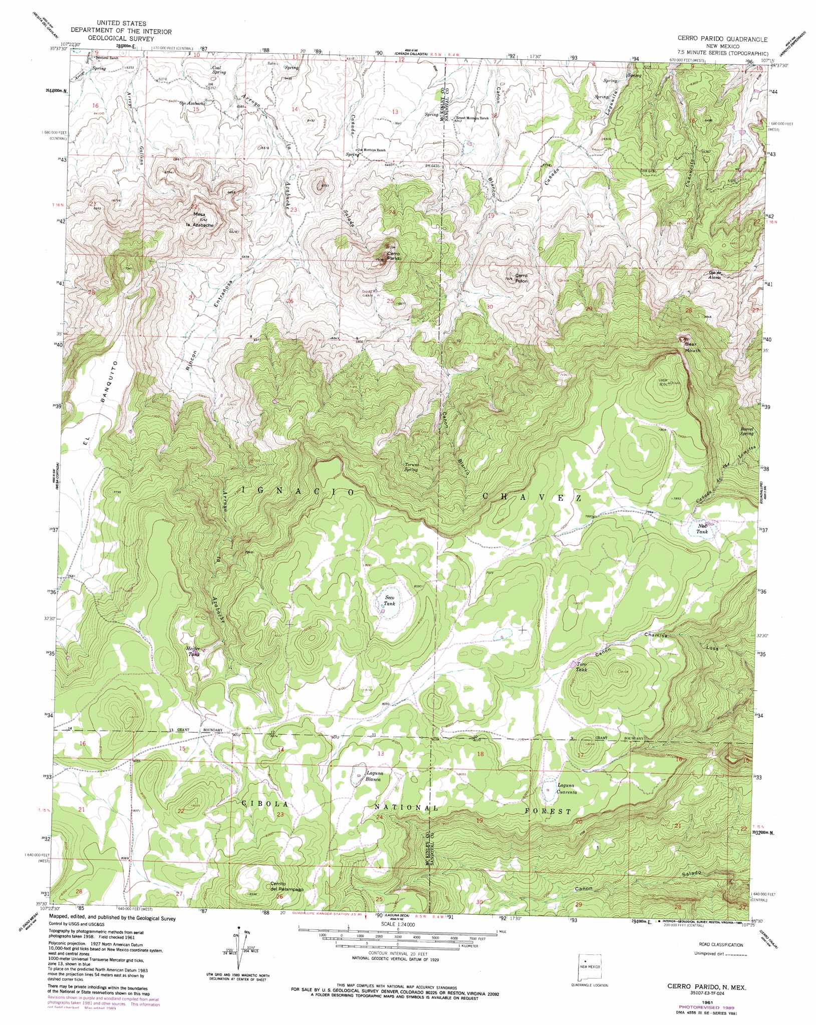
Cerro Parido Topo Map New Mexico
To zoom in, hover over the map of Cerro Parido
USGS Topo Quad 35107e3 - 1:24,000 scale
| Topo Map Name: | Cerro Parido |
| USGS Topo Quad ID: | 35107e3 |
| Print Size: | ca. 21 1/4" wide x 27" high |
| Southeast Coordinates: | 35.5° N latitude / 107.25° W longitude |
| Map Center Coordinates: | 35.5625° N latitude / 107.3125° W longitude |
| U.S. State: | NM |
| Filename: | o35107e3.jpg |
| Download Map JPG Image: | Cerro Parido topo map 1:24,000 scale |
| Map Type: | Topographic |
| Topo Series: | 7.5´ |
| Map Scale: | 1:24,000 |
| Source of Map Images: | United States Geological Survey (USGS) |
| Alternate Map Versions: |
Cerro Parido NM 1961, updated 1963 Download PDF Buy paper map Cerro Parido NM 1961, updated 1989 Download PDF Buy paper map Cerro Parido NM 1995, updated 1998 Download PDF Buy paper map Cerro Parido NM 2011 Download PDF Buy paper map Cerro Parido NM 2013 Download PDF Buy paper map Cerro Parido NM 2017 Download PDF Buy paper map |
| FStopo: | US Forest Service topo Cerro Parido is available: Download FStopo PDF Download FStopo TIF |
1:24,000 Topo Quads surrounding Cerro Parido
Whitehorse Rincon |
Rincon Marquez |
Tinian |
Wolf Stand |
Headcut Reservoir |
Mesita Americana |
Mesita Del Gavilan |
Canada Calladita |
Arroyo Empedrado |
San Luis |
El Dado |
Mesa Cortada |
Cerro Parido |
Guadalupe |
Cabezon Peak |
Cerro Alesna |
El Dado Mesa |
Laguna Seca |
Cerro Tinaja |
Casa Salazar |
Cerro Pelon |
Laguna Canoneros |
Marquez |
La Gotera |
Puerco Dam |
> Back to 35107e1 at 1:100,000 scale
> Back to 35106a1 at 1:250,000 scale
> Back to U.S. Topo Maps home
Cerro Parido topo map: Gazetteer
Cerro Parido: Benches
El Banquito elevation 2319m 7608′Cerro Parido: Lakes
Laguna Blanca elevation 2467m 8093′Laguna Cuarenta elevation 2412m 7913′
Ned Tank elevation 2388m 7834′
Cerro Parido: Reservoirs
Heifer Tank elevation 2395m 7857′Seco Tank elevation 2449m 8034′
Toro Tank elevation 2416m 7926′
Cerro Parido: Springs
Barrel Spring elevation 2197m 7208′Coal Spring elevation 1934m 6345′
Ojo Azabache elevation 1950m 6397′
Ojo de Alamo elevation 1951m 6400′
Salado Spring elevation 2159m 7083′
Toruno Spring elevation 2251m 7385′
Cerro Parido: Summits
Bear Mouth elevation 2347m 7700′Cerrito del Relampago elevation 2502m 8208′
Cerro Parido elevation 2292m 7519′
Cerro Pelon elevation 2137m 7011′
Mesa la Azabache elevation 2212m 7257′
Cerro Parido: Valleys
Rincon Entranosa elevation 1988m 6522′Cerro Parido: Wells
10017 Water Well elevation 1954m 6410′R-13 Water Well elevation 2023m 6637′
Cerro Parido digital topo map on disk
Buy this Cerro Parido topo map showing relief, roads, GPS coordinates and other geographical features, as a high-resolution digital map file on DVD: