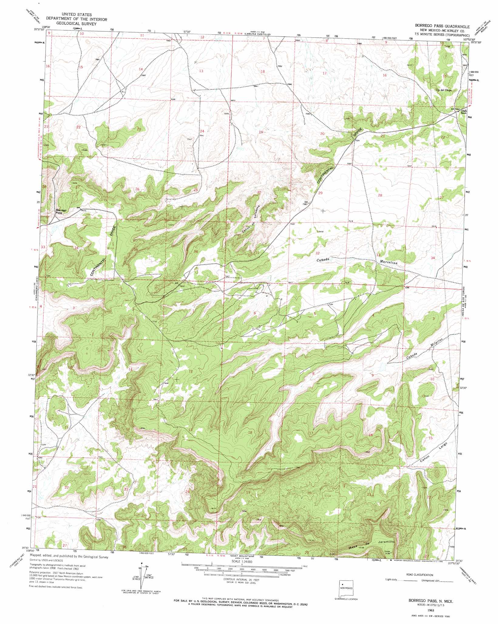
Borrego Pass Topo Map New Mexico
To zoom in, hover over the map of Borrego Pass
USGS Topo Quad 35107e8 - 1:24,000 scale
| Topo Map Name: | Borrego Pass |
| USGS Topo Quad ID: | 35107e8 |
| Print Size: | ca. 21 1/4" wide x 27" high |
| Southeast Coordinates: | 35.5° N latitude / 107.875° W longitude |
| Map Center Coordinates: | 35.5625° N latitude / 107.9375° W longitude |
| U.S. State: | NM |
| Filename: | o35107e8.jpg |
| Download Map JPG Image: | Borrego Pass topo map 1:24,000 scale |
| Map Type: | Topographic |
| Topo Series: | 7.5´ |
| Map Scale: | 1:24,000 |
| Source of Map Images: | United States Geological Survey (USGS) |
| Alternate Map Versions: |
Borrego Pass NM 1963, updated 1965 Download PDF Buy paper map Borrego Pass NM 2010 Download PDF Buy paper map Borrego Pass NM 2013 Download PDF Buy paper map Borrego Pass NM 2017 Download PDF Buy paper map |
1:24,000 Topo Quads surrounding Borrego Pass
Antelope Lookout Mesa |
Becenti Lake |
Seven Lakes |
Seven Lakes Se |
Whitehorse |
Crownpoint |
Heart Rock |
Laguna Castillo |
Orphan Annie Rock |
Hospah |
Hosta Butte |
Casamero Lake |
Borrego Pass |
Mesa De Los Toros |
Piedra De La Aguila |
Thoreau |
Thoreau Ne |
Goat Mountain |
Ambrosia Lake |
San Lucas Dam |
Pine Canyon |
Prewitt |
Bluewater |
Dos Lomas |
San Mateo |
> Back to 35107e1 at 1:100,000 scale
> Back to 35106a1 at 1:250,000 scale
> Back to U.S. Topo Maps home
Borrego Pass topo map: Gazetteer
Borrego Pass: Gaps
Borrego Pass elevation 2267m 7437′Borrego Pass: Mines
Barbara J HZ Mine elevation 2211m 7253′Holly Mine elevation 2211m 7253′
Mesa Top Mine elevation 2211m 7253′
Number 4 MOE Mine elevation 2211m 7253′
Tiejen Mine elevation 2251m 7385′
Borrego Pass: Springs
Ojo del Chopo elevation 2197m 7208′Borrego Pass: Streams
Cañon de Saladeta Canyon elevation 2148m 7047′Borrego Pass: Summits
Mesa de Jaramillo elevation 2496m 8188′Borrego Pass: Wells
15K-338 Water Well elevation 2285m 7496′15T-537 Water Well elevation 2194m 7198′
16T-561A Water Well elevation 2278m 7473′
223-18 Water Well elevation 2112m 6929′
80-1 Water Well elevation 2345m 7693′
Conoco-226 Water Well elevation 2112m 6929′
West Largo Water Well elevation 2307m 7568′
Borrego Pass digital topo map on disk
Buy this Borrego Pass topo map showing relief, roads, GPS coordinates and other geographical features, as a high-resolution digital map file on DVD: