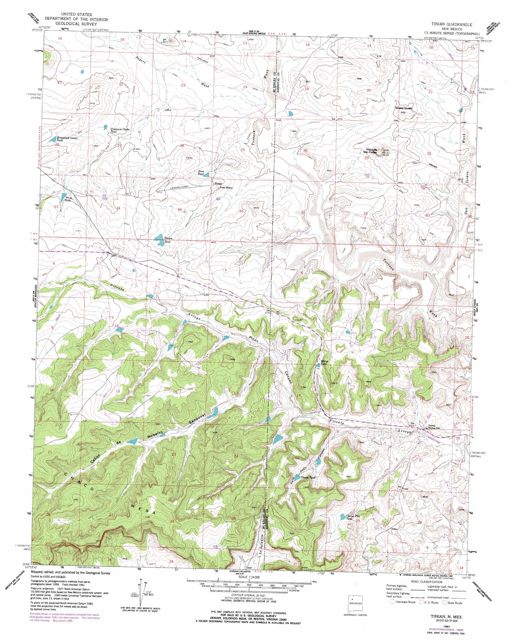
Tinian Topo Map New Mexico
To zoom in, hover over the map of Tinian
USGS Topo Quad 35107g3 - 1:24,000 scale
| Topo Map Name: | Tinian |
| USGS Topo Quad ID: | 35107g3 |
| Print Size: | ca. 21 1/4" wide x 27" high |
| Southeast Coordinates: | 35.75° N latitude / 107.25° W longitude |
| Map Center Coordinates: | 35.8125° N latitude / 107.3125° W longitude |
| U.S. State: | NM |
| Filename: | o35107g3.jpg |
| Download Map JPG Image: | Tinian topo map 1:24,000 scale |
| Map Type: | Topographic |
| Topo Series: | 7.5´ |
| Map Scale: | 1:24,000 |
| Source of Map Images: | United States Geological Survey (USGS) |
| Alternate Map Versions: |
Tinian NM 1961, updated 1963 Download PDF Buy paper map Tinian NM 1961, updated 1987 Download PDF Buy paper map Tinian NM 1961, updated 1989 Download PDF Buy paper map Tinian NM 2010 Download PDF Buy paper map Tinian NM 2013 Download PDF Buy paper map Tinian NM 2017 Download PDF Buy paper map |
1:24,000 Topo Quads surrounding Tinian
Lybrook Se |
Mule Dam |
Deer Mesa |
Taylor Ranch |
Arroyo Chijuillita |
Pueblo Alto Trading Post |
Star Lake |
Ojo Encino Mesa |
Johnson Trading Post |
Mesa Portales |
Whitehorse Rincon |
Rincon Marquez |
Tinian |
Wolf Stand |
Headcut Reservoir |
Mesita Americana |
Mesita Del Gavilan |
Canada Calladita |
Arroyo Empedrado |
San Luis |
El Dado |
Mesa Cortada |
Cerro Parido |
Guadalupe |
Cabezon Peak |
> Back to 35107e1 at 1:100,000 scale
> Back to 35106a1 at 1:250,000 scale
> Back to U.S. Topo Maps home
Tinian topo map: Gazetteer
Tinian: Dams
Chasm Dam elevation 2024m 6640′Pinon Canyon Dam Number Four elevation 2005m 6578′
Pinon Canyon Dam Number One elevation 2054m 6738′
Tinian: Populated Places
Tinian elevation 2027m 6650′Tinian: Reservoirs
Cactus Flat Tank elevation 2020m 6627′Chasm Tank elevation 2019m 6624′
Homestead Corner Tank elevation 2037m 6683′
Marys Tank elevation 2025m 6643′
Pinto Tank elevation 2037m 6683′
Store Tank elevation 2014m 6607′
Tinian Tank elevation 2031m 6663′
Uranium Claim Tank elevation 2013m 6604′
Tinian: Streams
Papers Wash elevation 1986m 6515′San Isidro Wash elevation 1951m 6400′
Tinian: Summits
Mesa de San Felipe elevation 2070m 6791′Sheep Queen Hill elevation 2027m 6650′
Tinian: Valleys
Julio Juan Canyon elevation 1963m 6440′Noberto Sandoval Cañon elevation 2000m 6561′
Piñon Canyon elevation 1948m 6391′
Tinian: Wells
15R-312 Water Well elevation 2030m 6660′15R-315 Water Well elevation 2071m 6794′
19K-333 Water Well elevation 2008m 6587′
R-51 Water Well elevation 1981m 6499′
Tinian digital topo map on disk
Buy this Tinian topo map showing relief, roads, GPS coordinates and other geographical features, as a high-resolution digital map file on DVD: