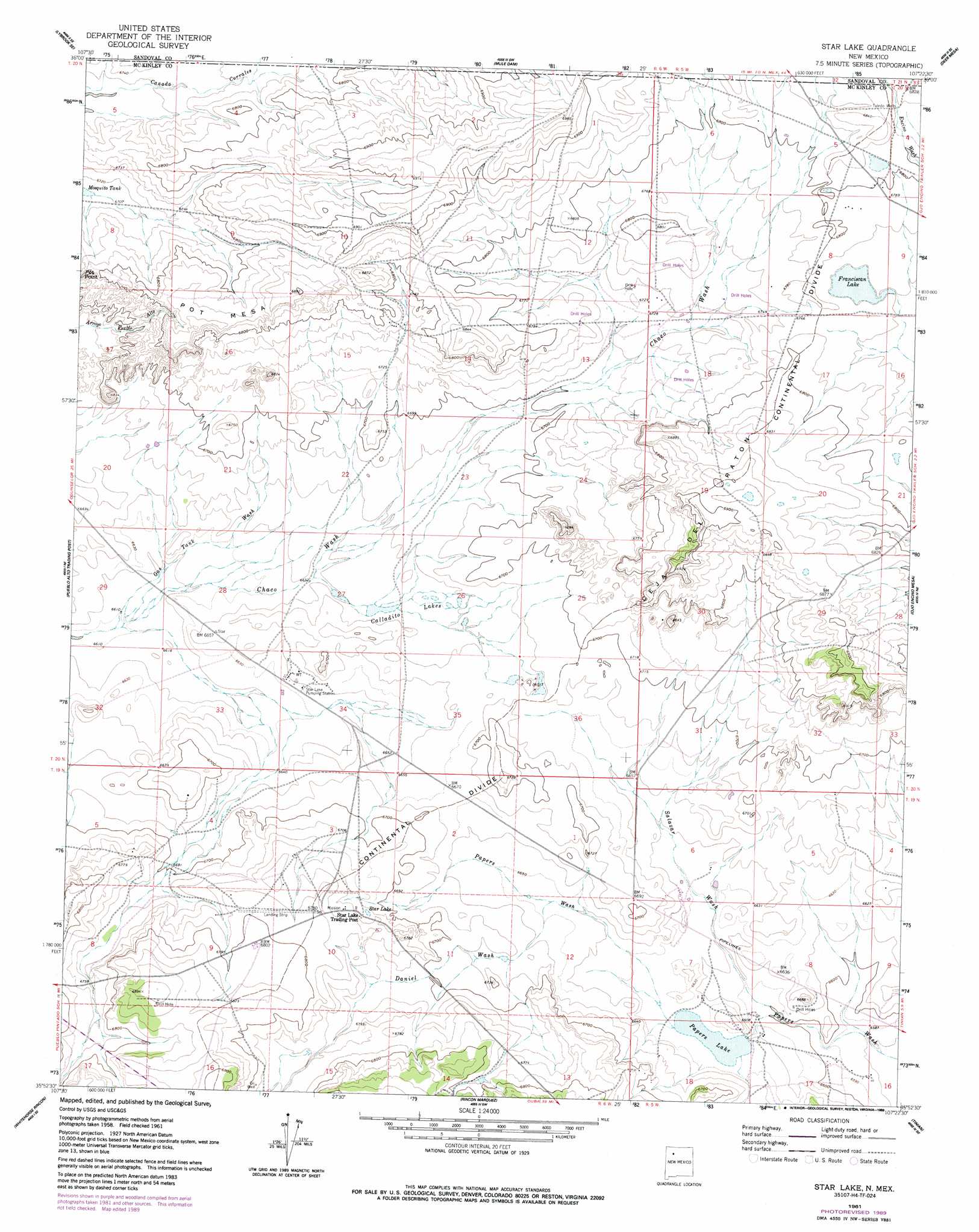
Star Lake Topo Map New Mexico
To zoom in, hover over the map of Star Lake
USGS Topo Quad 35107h4 - 1:24,000 scale
| Topo Map Name: | Star Lake |
| USGS Topo Quad ID: | 35107h4 |
| Print Size: | ca. 21 1/4" wide x 27" high |
| Southeast Coordinates: | 35.875° N latitude / 107.375° W longitude |
| Map Center Coordinates: | 35.9375° N latitude / 107.4375° W longitude |
| U.S. State: | NM |
| Filename: | o35107h4.jpg |
| Download Map JPG Image: | Star Lake topo map 1:24,000 scale |
| Map Type: | Topographic |
| Topo Series: | 7.5´ |
| Map Scale: | 1:24,000 |
| Source of Map Images: | United States Geological Survey (USGS) |
| Alternate Map Versions: |
Star Lake NM 1961, updated 1963 Download PDF Buy paper map Star Lake NM 1961, updated 1989 Download PDF Buy paper map Star Lake NM 2010 Download PDF Buy paper map Star Lake NM 2013 Download PDF Buy paper map Star Lake NM 2017 Download PDF Buy paper map |
1:24,000 Topo Quads surrounding Star Lake
Lybrook Nw |
Lybrook |
Counselor |
Tancosa Windmill |
Five Lakes Canyon Nw |
Fire Rock Well |
Lybrook Se |
Mule Dam |
Deer Mesa |
Taylor Ranch |
Pueblo Pintado |
Pueblo Alto Trading Post |
Star Lake |
Ojo Encino Mesa |
Johnson Trading Post |
Whitehorse |
Whitehorse Rincon |
Rincon Marquez |
Tinian |
Wolf Stand |
Hospah |
Mesita Americana |
Mesita Del Gavilan |
Canada Calladita |
Arroyo Empedrado |
> Back to 35107e1 at 1:100,000 scale
> Back to 35106a1 at 1:250,000 scale
> Back to U.S. Topo Maps home
Star Lake topo map: Gazetteer
Star Lake: Benches
Pot Mesa elevation 2084m 6837′Star Lake: Lakes
Franciscan Lake elevation 2060m 6758′Papers Lake elevation 2020m 6627′
Star Lake elevation 2051m 6729′
Star Lake: Reservoirs
Calladito Lakes elevation 2029m 6656′Star Lake: Streams
Daniel Wash elevation 2028m 6653′Gas Tank Wash elevation 2015m 6610′
Salazar Wash elevation 2012m 6601′
Star Lake: Valleys
Ceja del Raton elevation 2094m 6870′Star Lake: Wells
1 Water Well elevation 2017m 6617′CCR 22 Water Well elevation 2016m 6614′
D4-OE-1 Water Well elevation 2041m 6696′
DH-OE-1A Water Well elevation 2040m 6692′
DH-OE-2 Water Well elevation 2025m 6643′
Division F Water Well elevation 2062m 6765′
Star Lake 1 Water Well elevation 2025m 6643′
Well 2 Water Well elevation 2017m 6617′
Star Lake digital topo map on disk
Buy this Star Lake topo map showing relief, roads, GPS coordinates and other geographical features, as a high-resolution digital map file on DVD: