Upper Nutria Topo Map New Mexico
To zoom in, hover over the map of Upper Nutria
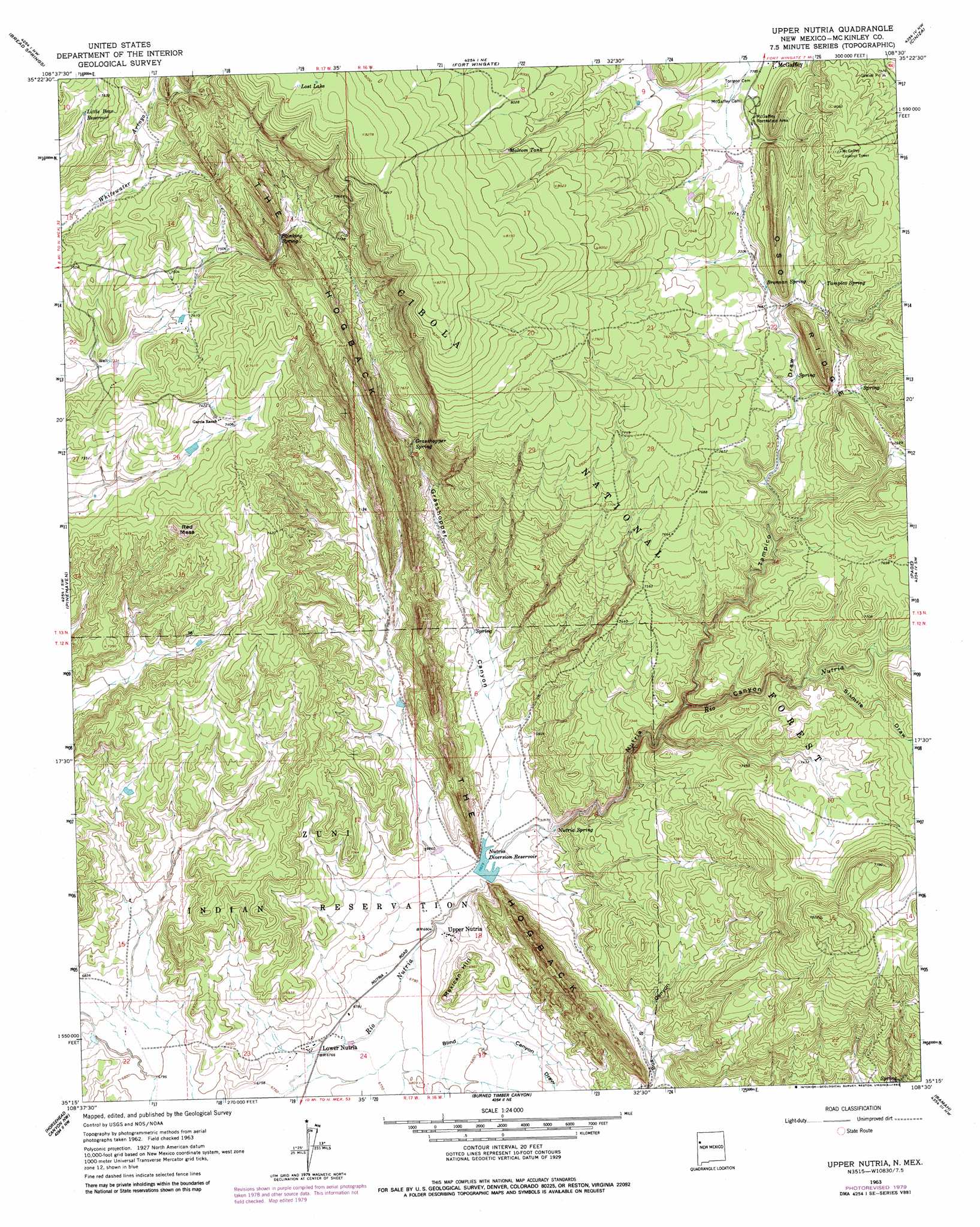
USGS Topo Quad 35108c5 - 1:24,000 scale
| Topo Map Name: | Upper Nutria |
| USGS Topo Quad ID: | 35108c5 |
| Print Size: | ca. 21 1/4" wide x 27" high |
| Southeast Coordinates: | 35.25° N latitude / 108.5° W longitude |
| Map Center Coordinates: | 35.3125° N latitude / 108.5625° W longitude |
| U.S. State: | NM |
| Filename: | o35108c5.jpg |
| Download Map JPG Image: | Upper Nutria topo map 1:24,000 scale |
| Map Type: | Topographic |
| Topo Series: | 7.5´ |
| Map Scale: | 1:24,000 |
| Source of Map Images: | United States Geological Survey (USGS) |
| Alternate Map Versions: |
Upper Nutria NM 1963, updated 1967 Download PDF Buy paper map Upper Nutria NM 1963, updated 1980 Download PDF Buy paper map Upper Nutria NM 1995, updated 1998 Download PDF Buy paper map Upper Nutria NM 2011 Download PDF Buy paper map Upper Nutria NM 2013 Download PDF Buy paper map |
| FStopo: | US Forest Service topo Upper Nutria is available: Download FStopo PDF Download FStopo TIF |
1:24,000 Topo Quads surrounding Upper Nutria
Gallup West |
Gallup East |
Church Rock |
Pinedale |
Mariano Lake |
Twin Buttes |
Bread Springs |
Fort Wingate |
Ciniza |
Continental Divide |
Vander Wagen |
Pinehaven |
Upper Nutria |
Page |
Cottonwood Canyon |
Vanderwagen Draw |
Horsehead Canyon Nw |
Burned Timber Canyon |
Ramah |
Kettner Canyon |
Zuni |
Horsehead Canyon |
Pescado |
Togeye Lake |
El Morro |
> Back to 35108a1 at 1:100,000 scale
> Back to 35108a1 at 1:250,000 scale
> Back to U.S. Topo Maps home
Upper Nutria topo map: Gazetteer
Upper Nutria: Lakes
Lost Lake elevation 2521m 8270′Upper Nutria: Mines
Jurgensen Pit elevation 2117m 6945′Upper Nutria Limestone Pit elevation 2117m 6945′
Upper Nutria: Parks
McGaffey Camp and Picnic Grounds elevation 2376m 7795′Upper Nutria: Populated Places
Lower Nutria elevation 2067m 6781′Upper Nutria elevation 2076m 6811′
Upper Nutria: Reservoirs
Brennan Tank elevation 2368m 7769′Little Bear Reservoir elevation 2317m 7601′
Malcom Tank elevation 2444m 8018′
Nutria Diversion Reservoir elevation 2083m 6833′
Section Tank elevation 2371m 7778′
Upper Nutria: Springs
Brennan Spring elevation 2346m 7696′Grasshopper Spring elevation 2253m 7391′
Indian Spring elevation 2157m 7076′
Nutria Spring elevation 2100m 6889′
Stinking Spring elevation 2337m 7667′
Tampico Spring elevation 2387m 7831′
Upper Nutria: Streams
Agua Remora elevation 2285m 7496′Upper Nutria: Summits
Mexican Hill elevation 2125m 6971′Red Mesa elevation 2311m 7582′
Upper Nutria: Valleys
Grasshopper Canyon elevation 2087m 6847′Nutria Canyon elevation 2087m 6847′
Sixmile Draw elevation 2266m 7434′
Tampico Draw elevation 2194m 7198′
Upper Nutria digital topo map on disk
Buy this Upper Nutria topo map showing relief, roads, GPS coordinates and other geographical features, as a high-resolution digital map file on DVD: