Twin Buttes Topo Map New Mexico
To zoom in, hover over the map of Twin Buttes
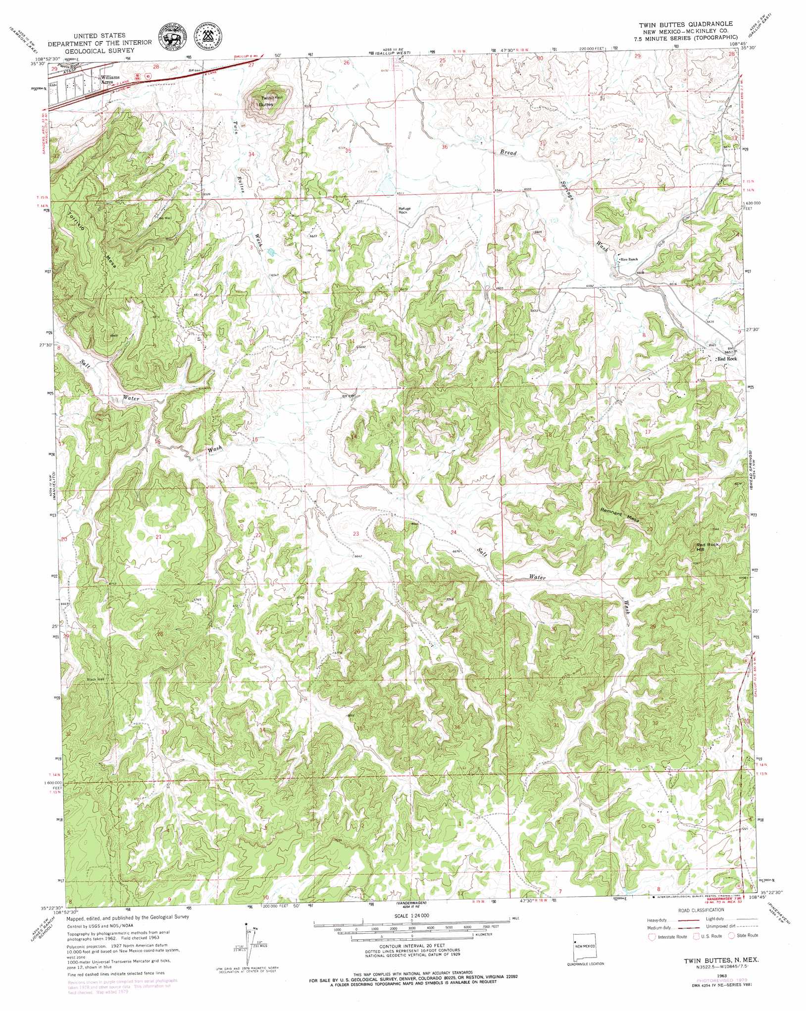
USGS Topo Quad 35108d7 - 1:24,000 scale
| Topo Map Name: | Twin Buttes |
| USGS Topo Quad ID: | 35108d7 |
| Print Size: | ca. 21 1/4" wide x 27" high |
| Southeast Coordinates: | 35.375° N latitude / 108.75° W longitude |
| Map Center Coordinates: | 35.4375° N latitude / 108.8125° W longitude |
| U.S. State: | NM |
| Filename: | o35108d7.jpg |
| Download Map JPG Image: | Twin Buttes topo map 1:24,000 scale |
| Map Type: | Topographic |
| Topo Series: | 7.5´ |
| Map Scale: | 1:24,000 |
| Source of Map Images: | United States Geological Survey (USGS) |
| Alternate Map Versions: |
Twin Buttes NM 1963, updated 1967 Download PDF Buy paper map Twin Buttes NM 1963, updated 1980 Download PDF Buy paper map Twin Buttes NM 2011 Download PDF Buy paper map Twin Buttes NM 2013 Download PDF Buy paper map Twin Buttes NM 2017 Download PDF Buy paper map |
1:24,000 Topo Quads surrounding Twin Buttes
Window Rock |
Tse Bonita School |
Twin Lakes |
Big Rock Hill |
Hard Ground Flats |
Hunters Point |
Samson Lake |
Gallup West |
Gallup East |
Church Rock |
Surrender Canyon |
Manuelito |
Twin Buttes |
Bread Springs |
Fort Wingate |
Lupton |
Jones Ranch School |
Vander Wagen |
Pinehaven |
Upper Nutria |
Chafin Well |
Chi Chil Tah |
Vanderwagen Draw |
Horsehead Canyon Nw |
Burned Timber Canyon |
> Back to 35108a1 at 1:100,000 scale
> Back to 35108a1 at 1:250,000 scale
> Back to U.S. Topo Maps home
Twin Buttes topo map: Gazetteer
Twin Buttes: Mines
Gallup Titanium Deposit elevation 2091m 6860′Grenko Mine elevation 2041m 6696′
Leyba Mine elevation 2060m 6758′
Manning Mine elevation 1990m 6528′
Olson Pit elevation 1970m 6463′
Thatcher Mine elevation 1991m 6532′
Twin Buttes Pit elevation 1961m 6433′
U.S. Mining-Olsen Mine elevation 2003m 6571′
Twin Buttes: Populated Places
Red Rock elevation 2029m 6656′Twin Buttes: Summits
Red Rock Hill elevation 2204m 7230′Refuge Rock elevation 1999m 6558′
Remnant Mesa elevation 2216m 7270′
Torrivio Mesa elevation 2148m 7047′
Twin Knoll Buttes elevation 2092m 6863′
Twin Buttes: Wells
Black Well elevation 2083m 6833′Mutual Col Water Well elevation 1989m 6525′
Tree Well elevation 2008m 6587′
Twin Buttes digital topo map on disk
Buy this Twin Buttes topo map showing relief, roads, GPS coordinates and other geographical features, as a high-resolution digital map file on DVD: