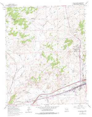
Gallup West Topo Map New Mexico
To zoom in, hover over the map of Gallup West
USGS Topo Quad 35108e7 - 1:24,000 scale
| Topo Map Name: | Gallup West |
| USGS Topo Quad ID: | 35108e7 |
| Print Size: | ca. 21 1/4" wide x 27" high |
| Southeast Coordinates: | 35.5° N latitude / 108.75° W longitude |
| Map Center Coordinates: | 35.5625° N latitude / 108.8125° W longitude |
| U.S. State: | NM |
| Filename: | o35108e7.jpg |
| Download Map JPG Image: | Gallup West topo map 1:24,000 scale |
| Map Type: | Topographic |
| Topo Series: | 7.5´ |
| Map Scale: | 1:24,000 |
| Source of Map Images: | United States Geological Survey (USGS) |
| Alternate Map Versions: |
Gallup West NM 1963, updated 1967 Download PDF Buy paper map Gallup West NM 1963, updated 1979 Download PDF Buy paper map Gallup West NM 1963, updated 1984 Download PDF Buy paper map Gallup West NM 2010 Download PDF Buy paper map Gallup West NM 2013 Download PDF Buy paper map Gallup West NM 2017 Download PDF Buy paper map |
1:24,000 Topo Quads surrounding Gallup West
> Back to 35108e1 at 1:100,000 scale
> Back to 35108a1 at 1:250,000 scale
> Back to U.S. Topo Maps home
Gallup West topo map: Gazetteer
Gallup West: Airports
Gallup Municipal Airport elevation 1971m 6466′Gallup West: Arroyos
Bread Springs Wash elevation 1963m 6440′Gallup West: Basins
Coal Basin elevation 1992m 6535′Gallup West: Mines
Carbon City Mine elevation 1988m 6522′Defiance Mine elevation 1958m 6423′
Enterprise Mine elevation 2012m 6601′
George Coal Mine elevation 2063m 6768′
Gibson Number 4 Mine elevation 2013m 6604′
Grenko Coal Mine elevation 1983m 6505′
Kennedy Mine elevation 2063m 6768′
MC Dermott Mine elevation 1980m 6496′
McDermott Et Al Prospect elevation 1986m 6515′
Mentmore Coal Mine elevation 1969m 6459′
Navajo Number 5 elevation 2060m 6758′
Navajo Number Five Mine elevation 2046m 6712′
New Mine elevation 1962m 6437′
New Mutual Coal Mine elevation 2007m 6584′
Tietjen Prospect elevation 1986m 6515′
Tomada Coal Mine elevation 1962m 6437′
Winter Mine elevation 2002m 6568′
Gallup West: Populated Places
Allison elevation 1977m 6486′Gamerco elevation 2051m 6729′
Mentmore elevation 1959m 6427′
Rock Springs elevation 2006m 6581′
Twin Buttes elevation 1960m 6430′
Gallup West: Post Offices
Allison Post Office (historical) elevation 1977m 6486′Gamerco Post Office (historical) elevation 2051m 6729′
Mentmore Post Office elevation 1959m 6427′
Gallup West: Springs
China Springs elevation 2085m 6840′Gallup West: Streams
Black Ridge Wash elevation 1983m 6505′Burned Death Wash elevation 1946m 6384′
Gamerco Wash elevation 1976m 6482′
Many Arrow Wash elevation 1977m 6486′
Twin Buttes Wash elevation 1946m 6384′
White Smoke Wash elevation 1982m 6502′
Gallup West: Valleys
Gibson Canyon elevation 1999m 6558′Gallup West: Wells
10004 Water Well elevation 1987m 6519′Munoz 1-A Water Well elevation 2019m 6624′
Gallup West digital topo map on disk
Buy this Gallup West topo map showing relief, roads, GPS coordinates and other geographical features, as a high-resolution digital map file on DVD:


