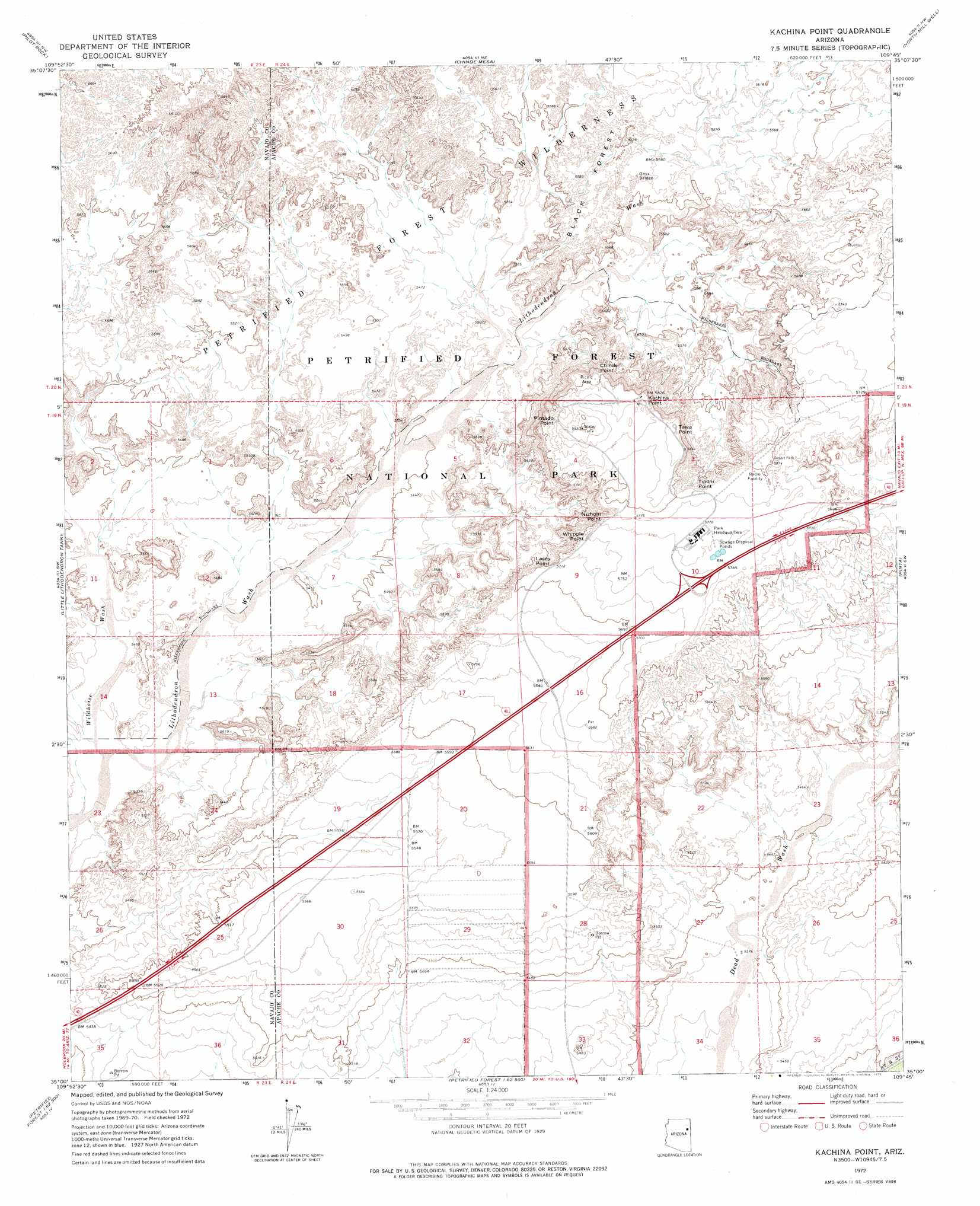
Kachina Point Topo Map Arizona
To zoom in, hover over the map of Kachina Point
USGS Topo Quad 35109a7 - 1:24,000 scale
| Topo Map Name: | Kachina Point |
| USGS Topo Quad ID: | 35109a7 |
| Print Size: | ca. 21 1/4" wide x 27" high |
| Southeast Coordinates: | 35° N latitude / 109.75° W longitude |
| Map Center Coordinates: | 35.0625° N latitude / 109.8125° W longitude |
| U.S. State: | AZ |
| Filename: | o35109a7.jpg |
| Download Map JPG Image: | Kachina Point topo map 1:24,000 scale |
| Map Type: | Topographic |
| Topo Series: | 7.5´ |
| Map Scale: | 1:24,000 |
| Source of Map Images: | United States Geological Survey (USGS) |
| Alternate Map Versions: |
Kachina Point AZ 1972, updated 1975 Download PDF Buy paper map Kachina Point AZ 2011 Download PDF Buy paper map Kachina Point AZ 2014 Download PDF Buy paper map |
1:24,000 Topo Quads surrounding Kachina Point
Five Buttes |
Arrowhead Butte |
Betty Well |
Tanner Springs |
Dipping Water Well |
Mitten Peak |
Pilot Rock |
Chinde Mesa |
North Mill Well |
Navajo North |
Hennessy Buttes |
Little Lithodendron Tank |
Kachina Point |
Pinta |
Navajo South |
Sun Valley |
Carrizo Butte |
Adamana |
Sorrel Horse Mesa |
Ninemile Seep |
Woodruff |
Padilla Tank |
Agate House |
Milky Ranch |
Seven Springs |
> Back to 35109a1 at 1:100,000 scale
> Back to 35108a1 at 1:250,000 scale
> Back to U.S. Topo Maps home
Kachina Point topo map: Gazetteer
Kachina Point: Arches
Onyx Bridge elevation 1689m 5541′Kachina Point: Areas
Black Forest elevation 1693m 5554′Kachina Point: Cliffs
Chinde Point elevation 1733m 5685′Kachina Point elevation 1776m 5826′
Lacey Point elevation 1718m 5636′
Nizhoni Point elevation 1735m 5692′
Pintado Point elevation 1788m 5866′
Tawa Point elevation 1783m 5849′
Tiponi Point elevation 1745m 5725′
Whipple Point elevation 1730m 5675′
Kachina Point: Crossings
Petrified Forest Overpass elevation 1725m 5659′Kachina Point: Parks
Petrified Forest National Park elevation 1657m 5436′Kachina Point: Streams
Wildhorse Wash elevation 1622m 5321′Kachina Point digital topo map on disk
Buy this Kachina Point topo map showing relief, roads, GPS coordinates and other geographical features, as a high-resolution digital map file on DVD: