Lupton Topo Map Arizona
To zoom in, hover over the map of Lupton
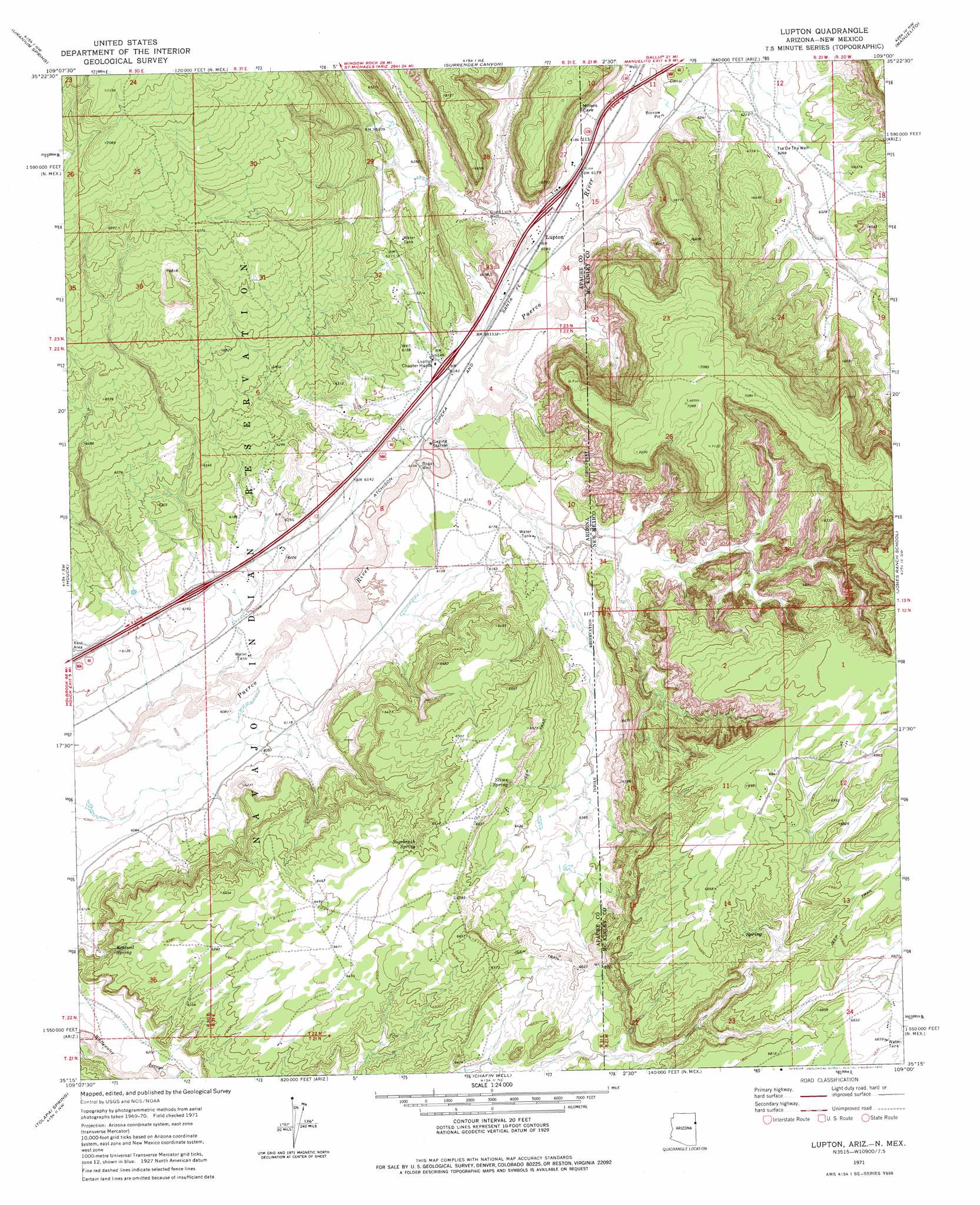
USGS Topo Quad 35109c1 - 1:24,000 scale
| Topo Map Name: | Lupton |
| USGS Topo Quad ID: | 35109c1 |
| Print Size: | ca. 21 1/4" wide x 27" high |
| Southeast Coordinates: | 35.25° N latitude / 109° W longitude |
| Map Center Coordinates: | 35.3125° N latitude / 109.0625° W longitude |
| U.S. States: | AZ, NM |
| Filename: | o35109c1.jpg |
| Download Map JPG Image: | Lupton topo map 1:24,000 scale |
| Map Type: | Topographic |
| Topo Series: | 7.5´ |
| Map Scale: | 1:24,000 |
| Source of Map Images: | United States Geological Survey (USGS) |
| Alternate Map Versions: |
Lupton AZ 1971, updated 1975 Download PDF Buy paper map Lupton AZ 2010 Download PDF Buy paper map Lupton AZ 2011 Download PDF Buy paper map Lupton AZ 2014 Download PDF Buy paper map |
1:24,000 Topo Quads surrounding Lupton
Antelope Lake |
Joe Woody Well |
Hunters Point |
Samson Lake |
Gallup West |
Pine Springs |
Uranium Spring |
Surrender Canyon |
Manuelito |
Twin Buttes |
Burntwater Wash |
Houck |
Lupton |
Jones Ranch School |
Vander Wagen |
Sanders |
Tolapai Spring |
Chafin Well |
Chi Chil Tah |
Vanderwagen Draw |
Beacon Well |
Deep Lake |
High Lonesome Well |
Tekapo |
Zuni |
> Back to 35109a1 at 1:100,000 scale
> Back to 35108a1 at 1:250,000 scale
> Back to U.S. Topo Maps home
Lupton topo map: Gazetteer
Lupton: Arroyos
Whitewater Arroyo elevation 1883m 6177′Lupton: Crossings
Hawthorne Interchange elevation 1872m 6141′Lupton Interchange elevation 1889m 6197′
Window Rock Interchange elevation 1879m 6164′
Lupton: Populated Places
Lupton elevation 1886m 6187′Lupton: Springs
Keetsell Spring elevation 1914m 6279′Sagebrush Spring elevation 0m 0′
Slims Spring elevation 1986m 6515′
Lupton: Wells
Begay Well elevation 1860m 6102′Tse De Tha Well elevation 1915m 6282′
Lupton digital topo map on disk
Buy this Lupton topo map showing relief, roads, GPS coordinates and other geographical features, as a high-resolution digital map file on DVD: