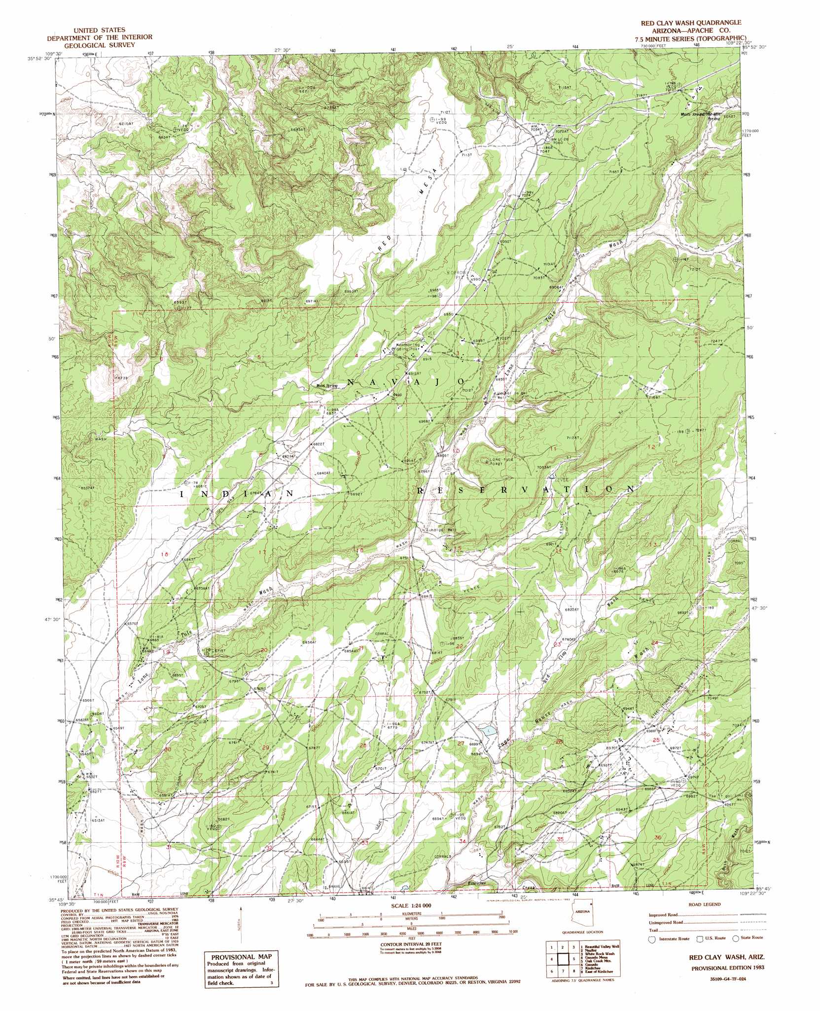
Red Clay Wash Topo Map Arizona
To zoom in, hover over the map of Red Clay Wash
USGS Topo Quad 35109g4 - 1:24,000 scale
| Topo Map Name: | Red Clay Wash |
| USGS Topo Quad ID: | 35109g4 |
| Print Size: | ca. 21 1/4" wide x 27" high |
| Southeast Coordinates: | 35.75° N latitude / 109.375° W longitude |
| Map Center Coordinates: | 35.8125° N latitude / 109.4375° W longitude |
| U.S. State: | AZ |
| Filename: | o35109g4.jpg |
| Download Map JPG Image: | Red Clay Wash topo map 1:24,000 scale |
| Map Type: | Topographic |
| Topo Series: | 7.5´ |
| Map Scale: | 1:24,000 |
| Source of Map Images: | United States Geological Survey (USGS) |
| Alternate Map Versions: |
Zith-Tusayan Butte 2 SW AZ 1955, updated 1957 Download PDF Buy paper map Red Clay Wash AZ 1983, updated 1983 Download PDF Buy paper map Red Clay Wash AZ 2011 Download PDF Buy paper map Red Clay Wash AZ 2014 Download PDF Buy paper map |
1:24,000 Topo Quads surrounding Red Clay Wash
Toh De Niihe |
Little White House Ruins |
Three Turkey Canyon |
Spider Rock |
White Clay |
Tolani |
Beautiful Valley Well |
Nazlini |
White Rock Wash |
Sawmill |
Ganado Mesa Sw |
Ganado Mesa |
Red Clay Wash |
Oak Creek Mountain |
Piney Hill |
Cornfields |
Ganado |
Kinlichee |
East Of Kinlichee |
West Of Window Rock |
Sunrise Springs |
Klagetoh North |
Tudecoz Spring |
Antelope Lake |
Joe Woody Well |
> Back to 35109e1 at 1:100,000 scale
> Back to 35108a1 at 1:250,000 scale
> Back to U.S. Topo Maps home
Red Clay Wash topo map: Gazetteer
Red Clay Wash: Arroyos
Red Clay Wash elevation 2041m 6696′Red Clay Wash: Parks
Kinlichee Tribal Park elevation 2029m 6656′Red Clay Wash: Populated Places
Kinlichee elevation 2030m 6660′Wood Springs elevation 2068m 6784′
Woodspring Trading Post elevation 2107m 6912′
Red Clay Wash: Springs
White around the Mountain Spring elevation 2148m 7047′Wood Spring elevation 2078m 6817′
Red Clay Wash: Streams
Sage House Wash elevation 0m 0′Red Clay Wash: Wells
Lu Kai le gei Well elevation 2081m 6827′Lukaigai Well elevation 2047m 6715′
Tse lt gai Sinil Well elevation 2102m 6896′
Red Clay Wash digital topo map on disk
Buy this Red Clay Wash topo map showing relief, roads, GPS coordinates and other geographical features, as a high-resolution digital map file on DVD: