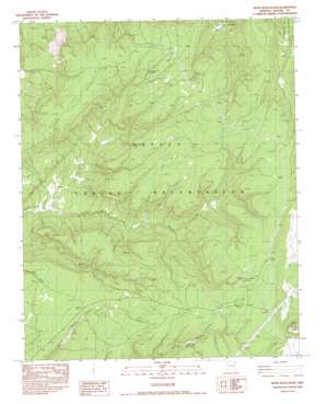
White Rock Wash Topo Map Arizona
To zoom in, hover over the map of White Rock Wash
USGS Topo Quad 35109h3 - 1:24,000 scale
| Topo Map Name: | White Rock Wash |
| USGS Topo Quad ID: | 35109h3 |
| Print Size: | ca. 21 1/4" wide x 27" high |
| Southeast Coordinates: | 35.875° N latitude / 109.25° W longitude |
| Map Center Coordinates: | 35.9375° N latitude / 109.3125° W longitude |
| U.S. State: | AZ |
| Filename: | o35109h3.jpg |
| Download Map JPG Image: | White Rock Wash topo map 1:24,000 scale |
| Map Type: | Topographic |
| Topo Series: | 7.5´ |
| Map Scale: | 1:24,000 |
| Source of Map Images: | United States Geological Survey (USGS) |
| Alternate Map Versions: |
Zith-Tusayan Butte 2 NE AZ 1955, updated 1957 Download PDF Buy paper map White Rock Wash AZ 1983, updated 1983 Download PDF Buy paper map White Rock Wash AZ 1983, updated 1983 Download PDF Buy paper map White Rock Wash AZ 2011 Download PDF Buy paper map White Rock Wash AZ 2014 Download PDF Buy paper map |
1:24,000 Topo Quads surrounding White Rock Wash
> Back to 35109e1 at 1:100,000 scale
> Back to 35108a1 at 1:250,000 scale
> Back to U.S. Topo Maps home
White Rock Wash topo map: Gazetteer
White Rock Wash: Springs
Honeymoon Spring elevation 2286m 7500′Tsegito Spring elevation 2328m 7637′
White Rock Spring elevation 2389m 7837′
White Rock Wash: Summits
Upper Forest Mountain elevation 2309m 7575′White Rock Wash: Valleys
White Rock Wash elevation 2066m 6778′White Rock Wash: Wells
Neyezee Well elevation 2308m 7572′White Rock Wash digital topo map on disk
Buy this White Rock Wash topo map showing relief, roads, GPS coordinates and other geographical features, as a high-resolution digital map file on DVD:


