Rotten Bananas Butte Topo Map Arizona
To zoom in, hover over the map of Rotten Bananas Butte
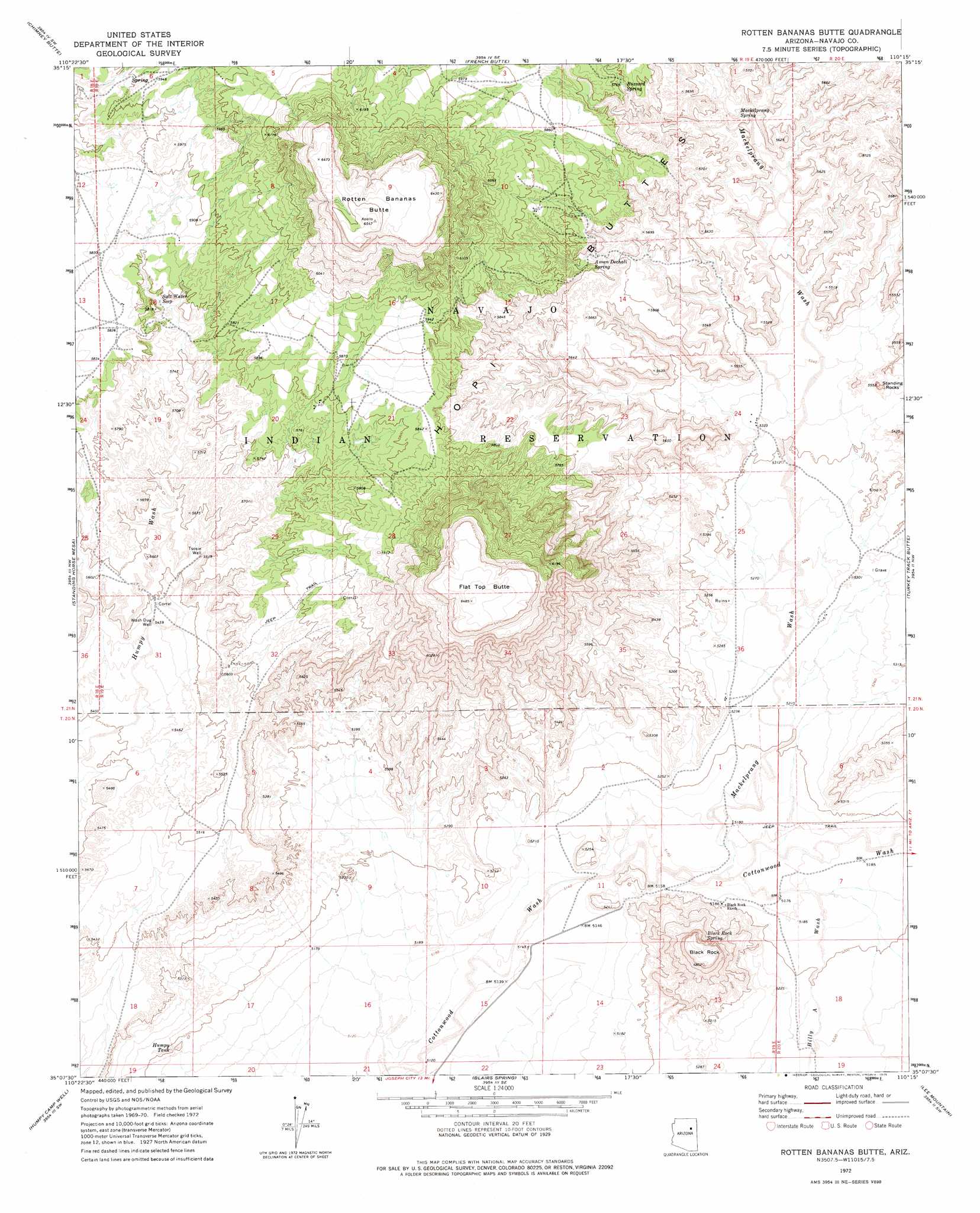
USGS Topo Quad 35110b3 - 1:24,000 scale
| Topo Map Name: | Rotten Bananas Butte |
| USGS Topo Quad ID: | 35110b3 |
| Print Size: | ca. 21 1/4" wide x 27" high |
| Southeast Coordinates: | 35.125° N latitude / 110.25° W longitude |
| Map Center Coordinates: | 35.1875° N latitude / 110.3125° W longitude |
| U.S. State: | AZ |
| Filename: | o35110b3.jpg |
| Download Map JPG Image: | Rotten Bananas Butte topo map 1:24,000 scale |
| Map Type: | Topographic |
| Topo Series: | 7.5´ |
| Map Scale: | 1:24,000 |
| Source of Map Images: | United States Geological Survey (USGS) |
| Alternate Map Versions: |
Rotten Bananas Butte AZ 1972, updated 1975 Download PDF Buy paper map Rotten Bananas Butte AZ 2011 Download PDF Buy paper map Rotten Bananas Butte AZ 2014 Download PDF Buy paper map |
1:24,000 Topo Quads surrounding Rotten Bananas Butte
Montezumas Chair |
Shonto Butte |
Dilkon |
Na Ah Tee Canyon |
Indian Wells |
Elephant Butte |
Chimney Butte |
French Butte |
Sunflower Butte |
Five Buttes |
Winslow Ne |
Standing Horse Mesa |
Rotten Bananas Butte |
Turkey Track Butte |
Mitten Peak |
Rincon Ranch |
Humpy Camp Well |
Blairs Spring |
Lee Mountain |
Hennessy Buttes |
Hibbard |
Apache Butte |
Joseph City |
Holbrook |
Sun Valley |
> Back to 35110a1 at 1:100,000 scale
> Back to 35110a1 at 1:250,000 scale
> Back to U.S. Topo Maps home
Rotten Bananas Butte topo map: Gazetteer
Rotten Bananas Butte: Pillars
Standing Rocks elevation 1656m 5433′Rotten Bananas Butte: Reservoirs
Humpy Tank elevation 1585m 5200′Rotten Bananas Butte: Springs
Assan Dechali Spring elevation 1725m 5659′Black Rock Spring elevation 1657m 5436′
Buzzard Spring elevation 1766m 5793′
Mackelprang Spring elevation 1683m 5521′
Salt Water Seep elevation 0m 0′
Rotten Bananas Butte: Streams
Billy Wash elevation 1576m 5170′Rotten Bananas Butte: Summits
Black Rock elevation 1767m 5797′Flat Top Butte elevation 1976m 6482′
Rotten Bananas Butte elevation 1996m 6548′
Rotten Bananas Butte: Valleys
Mackelprang Wash elevation 1573m 5160′Rotten Bananas Butte: Wells
Tsosie Well elevation 1685m 5528′Wash Dug Well elevation 1665m 5462′
Rotten Bananas Butte digital topo map on disk
Buy this Rotten Bananas Butte topo map showing relief, roads, GPS coordinates and other geographical features, as a high-resolution digital map file on DVD: