French Butte Topo Map Arizona
To zoom in, hover over the map of French Butte
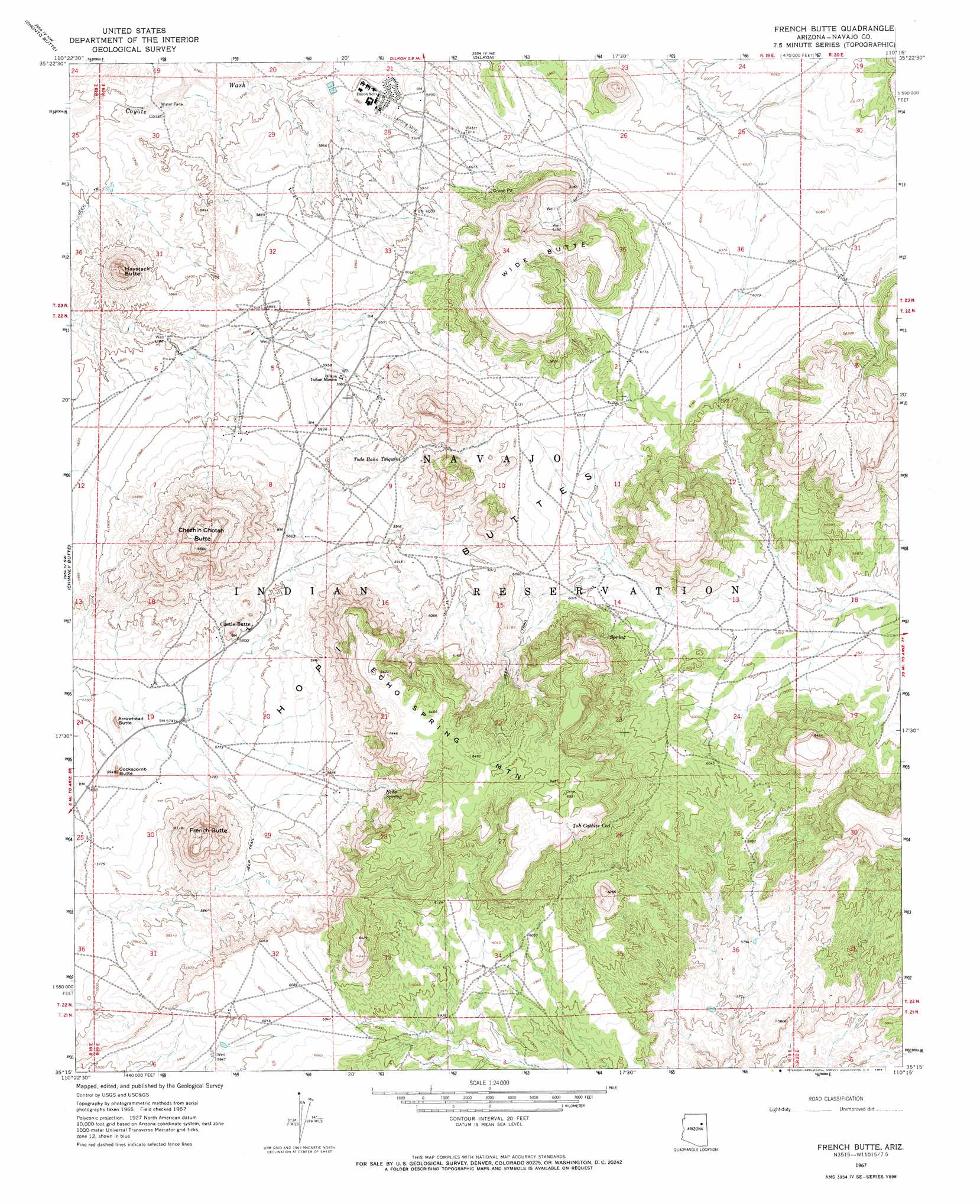
USGS Topo Quad 35110c3 - 1:24,000 scale
| Topo Map Name: | French Butte |
| USGS Topo Quad ID: | 35110c3 |
| Print Size: | ca. 21 1/4" wide x 27" high |
| Southeast Coordinates: | 35.25° N latitude / 110.25° W longitude |
| Map Center Coordinates: | 35.3125° N latitude / 110.3125° W longitude |
| U.S. State: | AZ |
| Filename: | o35110c3.jpg |
| Download Map JPG Image: | French Butte topo map 1:24,000 scale |
| Map Type: | Topographic |
| Topo Series: | 7.5´ |
| Map Scale: | 1:24,000 |
| Source of Map Images: | United States Geological Survey (USGS) |
| Alternate Map Versions: |
French Butte AZ 1967, updated 1969 Download PDF Buy paper map French Butte AZ 2011 Download PDF Buy paper map French Butte AZ 2014 Download PDF Buy paper map |
1:24,000 Topo Quads surrounding French Butte
Tovar Mesa East |
Egloffstein Butte |
Hauke Mesa |
First Flat Mesa |
White Cone |
Montezumas Chair |
Shonto Butte |
Dilkon |
Na Ah Tee Canyon |
Indian Wells |
Elephant Butte |
Chimney Butte |
French Butte |
Sunflower Butte |
Five Buttes |
Winslow Ne |
Standing Horse Mesa |
Rotten Bananas Butte |
Turkey Track Butte |
Mitten Peak |
Rincon Ranch |
Humpy Camp Well |
Blairs Spring |
Lee Mountain |
Hennessy Buttes |
> Back to 35110a1 at 1:100,000 scale
> Back to 35110a1 at 1:250,000 scale
> Back to U.S. Topo Maps home
French Butte topo map: Gazetteer
French Butte: Populated Places
Castle Butte elevation 1770m 5807′French Butte: Springs
Echo Spring elevation 1844m 6049′Tode Baho Tsiquini elevation 1819m 5967′
Toh Cathlie Cod elevation 1897m 6223′
French Butte: Summits
Arrowhead Butte elevation 1778m 5833′Chezhin Chotah Butte elevation 1973m 6473′
Cockscomb Butte elevation 1801m 5908′
Echo Spring Mountain elevation 1971m 6466′
French Butte elevation 1967m 6453′
Haystack Butte elevation 1904m 6246′
Wide Butte elevation 1977m 6486′
French Butte digital topo map on disk
Buy this French Butte topo map showing relief, roads, GPS coordinates and other geographical features, as a high-resolution digital map file on DVD: