Bellemont Topo Map Arizona
To zoom in, hover over the map of Bellemont
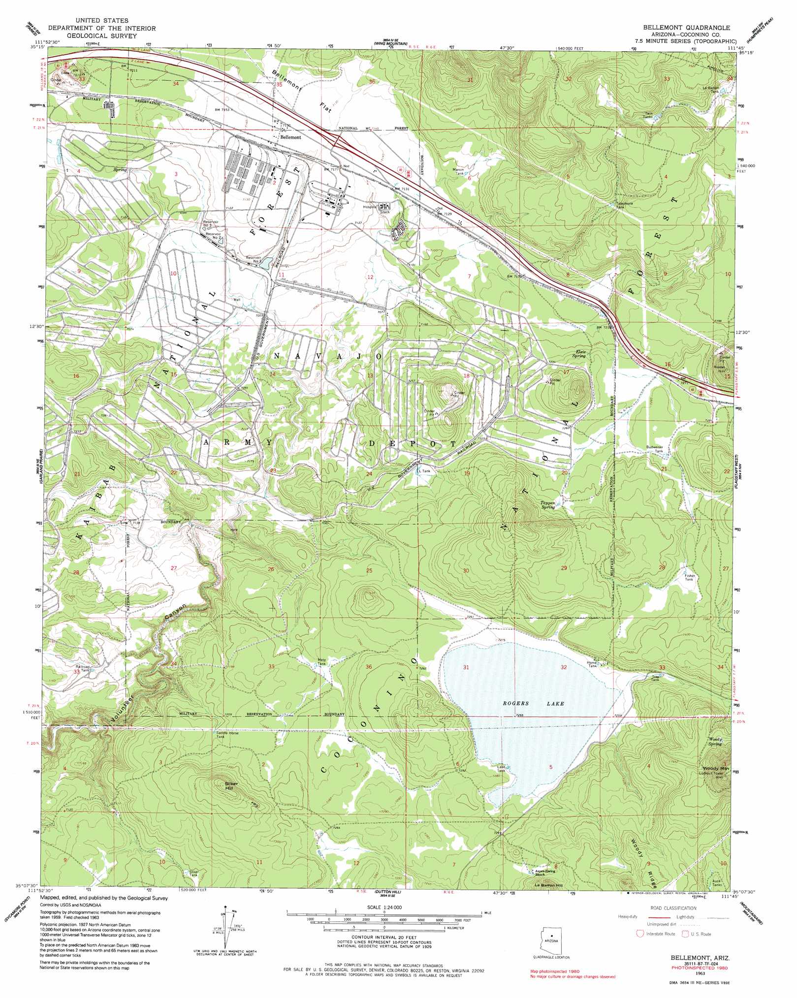
USGS Topo Quad 35111b7 - 1:24,000 scale
| Topo Map Name: | Bellemont |
| USGS Topo Quad ID: | 35111b7 |
| Print Size: | ca. 21 1/4" wide x 27" high |
| Southeast Coordinates: | 35.125° N latitude / 111.75° W longitude |
| Map Center Coordinates: | 35.1875° N latitude / 111.8125° W longitude |
| U.S. State: | AZ |
| Filename: | o35111b7.jpg |
| Download Map JPG Image: | Bellemont topo map 1:24,000 scale |
| Map Type: | Topographic |
| Topo Series: | 7.5´ |
| Map Scale: | 1:24,000 |
| Source of Map Images: | United States Geological Survey (USGS) |
| Alternate Map Versions: |
Bellemont AZ 1963, updated 1965 Download PDF Buy paper map Bellemont AZ 1963, updated 1973 Download PDF Buy paper map Bellemont AZ 1963, updated 1985 Download PDF Buy paper map Bellemont AZ 1963, updated 1991 Download PDF Buy paper map Bellemont AZ 2012 Download PDF Buy paper map Bellemont AZ 2014 Download PDF Buy paper map |
| FStopo: | US Forest Service topo Bellemont is available: Download FStopo PDF Download FStopo TIF |
1:24,000 Topo Quads surrounding Bellemont
Squaw Mountain |
Moritz Ridge |
Kendrick Peak |
White Horse Hills |
O'Leary Peak |
Sitgreaves Mountain |
Parks |
Wing Mountain |
Humphreys Peak |
Sunset Crater West |
Davenport Hill |
Garland Prairie |
Bellemont |
Flagstaff West |
Flagstaff East |
White Horse Lake |
Sycamore Point |
Dutton Hill |
Mountainaire |
Lower Lake Mary |
Sycamore Basin |
Loy Butte |
Wilson Mountain |
Munds Park |
Mormon Mountain |
> Back to 35111a1 at 1:100,000 scale
> Back to 35110a1 at 1:250,000 scale
> Back to U.S. Topo Maps home
Bellemont topo map: Gazetteer
Bellemont: Crossings
Navajo Interchange elevation 2177m 7142′Bellemont: Flats
Bellemont Flat elevation 2177m 7142′Bellemont: Lakes
Atherton Lake elevation 2153m 7063′Rogers Lake elevation 2214m 7263′
Bellemont: Populated Places
Bellemont elevation 2174m 7132′Bellemont: Reservoirs
A-One Tank elevation 2244m 7362′Aspen Spring Tank elevation 2250m 7381′
Auza Tanks elevation 2280m 7480′
Bear Tank elevation 2247m 7372′
Budweiser Tank elevation 2218m 7276′
Fisher Tank elevation 2238m 7342′
Hidden Tank elevation 2282m 7486′
Home Tank elevation 2217m 7273′
Horse Tank elevation 2161m 7089′
Johnson Tank elevation 2194m 7198′
Junction Tank elevation 2152m 7060′
Kelly Tank elevation 2145m 7037′
L Tank elevation 2193m 7194′
Lake Tank elevation 2193m 7194′
Lake Tank elevation 2214m 7263′
Le Barron Tank elevation 2240m 7349′
Marvin Tank elevation 2201m 7221′
Marvin Tank elevation 2194m 7198′
Marvin Tank elevation 2153m 7063′
Metz Tank elevation 2206m 7237′
Metz Tank elevation 2208m 7244′
Metz Tank elevation 2200m 7217′
Quarry Tank elevation 2153m 7063′
Railroad Tank elevation 2159m 7083′
Ray Tank elevation 2204m 7230′
Reservoir Number One elevation 2157m 7076′
Reservoir Number Three elevation 2157m 7076′
Reservoir Number Two elevation 2155m 7070′
Saddle Horse Tank elevation 2197m 7208′
Sliker Tank elevation 2194m 7198′
Telephone Tank elevation 2242m 7355′
Thompson Tank elevation 2182m 7158′
Tree Tank elevation 2225m 7299′
Turkey Number Three Tank elevation 2191m 7188′
Twin Tanks elevation 2263m 7424′
Bellemont: Springs
Ebert Spring elevation 2203m 7227′Elsie Spring elevation 2207m 7240′
Fishers Spring elevation 2244m 7362′
Marvin Spring (historical) elevation 2201m 7221′
Paterson Spring elevation 2238m 7342′
Tappen Spring elevation 2232m 7322′
Woody Spring elevation 2313m 7588′
Bellemont: Summits
Le Barron Hill elevation 2339m 7673′Sliker Hill elevation 2197m 7208′
Woody Mountain elevation 2446m 8024′
Bellemont digital topo map on disk
Buy this Bellemont topo map showing relief, roads, GPS coordinates and other geographical features, as a high-resolution digital map file on DVD: