Sunset Crater West Topo Map Arizona
To zoom in, hover over the map of Sunset Crater West
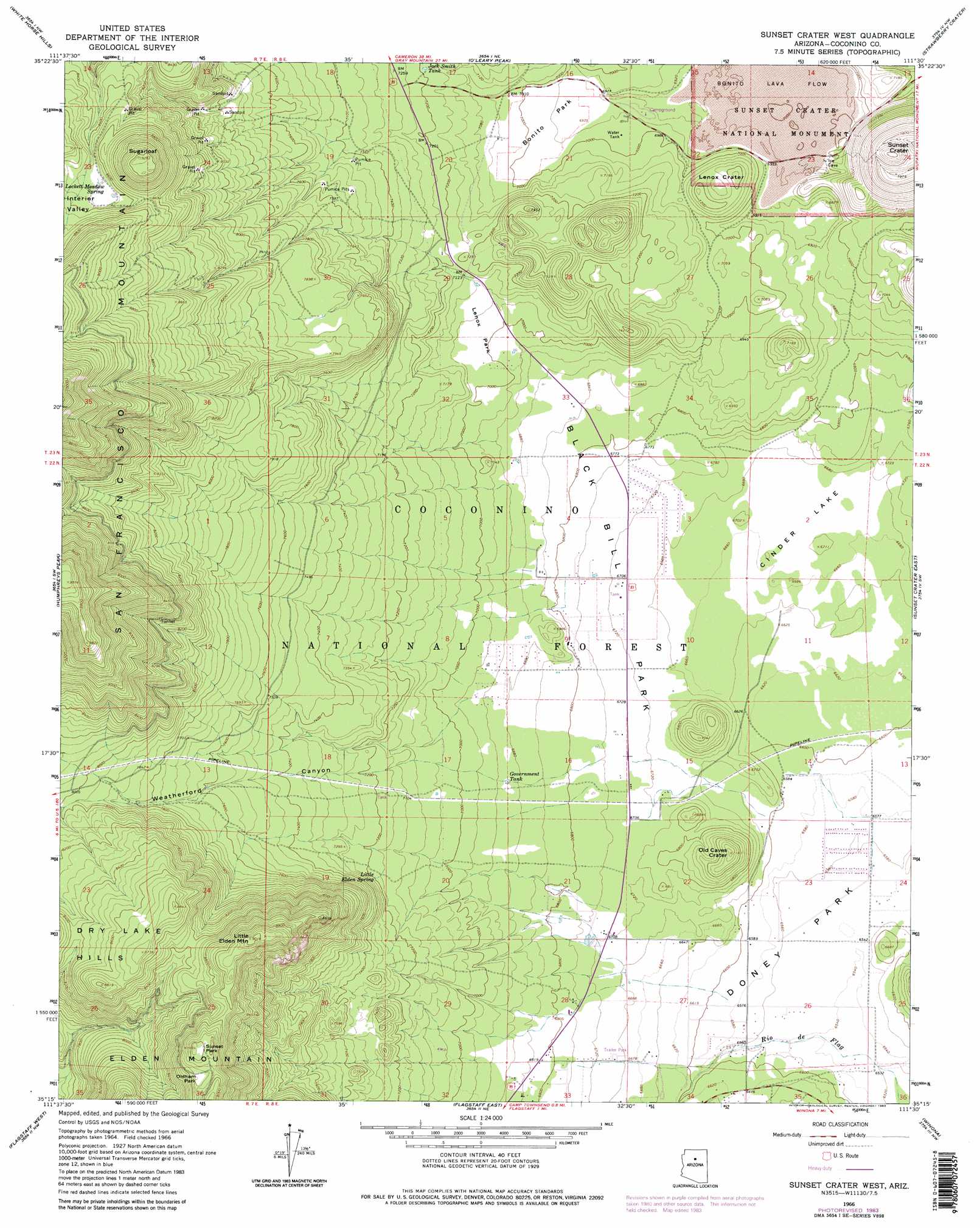
USGS Topo Quad 35111c5 - 1:24,000 scale
| Topo Map Name: | Sunset Crater West |
| USGS Topo Quad ID: | 35111c5 |
| Print Size: | ca. 21 1/4" wide x 27" high |
| Southeast Coordinates: | 35.25° N latitude / 111.5° W longitude |
| Map Center Coordinates: | 35.3125° N latitude / 111.5625° W longitude |
| U.S. State: | AZ |
| Filename: | o35111c5.jpg |
| Download Map JPG Image: | Sunset Crater West topo map 1:24,000 scale |
| Map Type: | Topographic |
| Topo Series: | 7.5´ |
| Map Scale: | 1:24,000 |
| Source of Map Images: | United States Geological Survey (USGS) |
| Alternate Map Versions: |
Sunset Crater West AZ 1966, updated 1968 Download PDF Buy paper map Sunset Crater West AZ 1966, updated 1976 Download PDF Buy paper map Sunset Crater West AZ 1966, updated 1983 Download PDF Buy paper map Sunset Crater West AZ 1966, updated 1983 Download PDF Buy paper map Sunset Crater West AZ 2011 Download PDF Buy paper map Sunset Crater West AZ 2014 Download PDF Buy paper map |
| FStopo: | US Forest Service topo Sunset Crater West is available: Download FStopo PDF Download FStopo TIF |
1:24,000 Topo Quads surrounding Sunset Crater West
Chapel Mountain |
S P Mountain |
East Of S P Mountain |
Wupatki Sw |
Wupatki Se |
Kendrick Peak |
White Horse Hills |
O'Leary Peak |
Strawberry Crater |
Roden Crater |
Wing Mountain |
Humphreys Peak |
Sunset Crater West |
Sunset Crater East |
Merriam Crater |
Bellemont |
Flagstaff West |
Flagstaff East |
Winona |
Angell |
Dutton Hill |
Mountainaire |
Lower Lake Mary |
Ashurst Lake |
Elliott Canyon |
> Back to 35111a1 at 1:100,000 scale
> Back to 35110a1 at 1:250,000 scale
> Back to U.S. Topo Maps home
Sunset Crater West topo map: Gazetteer
Sunset Crater West: Craters
Lenox Crater elevation 2166m 7106′Old Caves Crater elevation 2186m 7171′
Sunset Crater elevation 2312m 7585′
Sunset Crater West: Flats
Black Bill Park elevation 2048m 6719′Bonito Park elevation 2125m 6971′
Cinder Lake elevation 2033m 6669′
Doney Park elevation 1999m 6558′
Lenox Park elevation 2141m 7024′
Oldham Park elevation 2701m 8861′
Sunset Park elevation 2746m 9009′
Sunset Crater West: Forests
Fort Valley Experimental Forest elevation 2061m 6761′Peaks Ranger District elevation 2747m 9012′
Sunset Crater West: Lavas
Bonito Lava Flow elevation 2130m 6988′Sunset Crater West: Parks
Sunset Crater Volcano National Monument elevation 2127m 6978′Sunset Crater West: Reservoirs
Black Bill Tank elevation 2145m 7037′Eighty-nine Tank elevation 2394m 7854′
Government Tank elevation 2104m 6902′
Jack Smith Tank elevation 2193m 7194′
Lennox Tank elevation 2366m 7762′
Lenoux Tank elevation 2216m 7270′
Locket Meadow Tank elevation 2607m 8553′
Railroad Tank elevation 2139m 7017′
Summit Tank elevation 2181m 7155′
Thompson Tank elevation 2074m 6804′
Sunset Crater West: Springs
Jack Smith Spring Number Two elevation 2388m 7834′Little Elden Spring elevation 2193m 7194′
Lockett Meadow Spring elevation 2597m 8520′
Sunset Crater West: Summits
Deer Hill elevation 2264m 7427′Elden Mountain elevation 2612m 8569′
Little Elden Mountain elevation 2748m 9015′
Sugarloaf Peak elevation 2831m 9288′
Sunset Crater West: Trails
Lava Flow Trail elevation 2122m 6961′Lenox Trail elevation 2137m 7011′
Sunset Crater West: Valleys
Interior Valley elevation 2575m 8448′Weatherford Canyon elevation 2062m 6765′
Sunset Crater West digital topo map on disk
Buy this Sunset Crater West topo map showing relief, roads, GPS coordinates and other geographical features, as a high-resolution digital map file on DVD: