Humphreys Peak Topo Map Arizona
To zoom in, hover over the map of Humphreys Peak
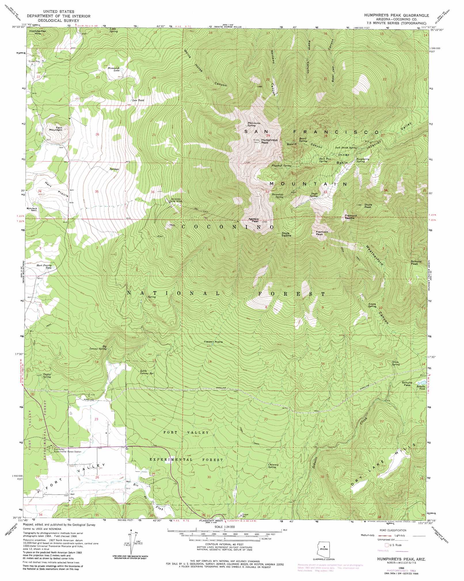
USGS Topo Quad 35111c6 - 1:24,000 scale
| Topo Map Name: | Humphreys Peak |
| USGS Topo Quad ID: | 35111c6 |
| Print Size: | ca. 21 1/4" wide x 27" high |
| Southeast Coordinates: | 35.25° N latitude / 111.625° W longitude |
| Map Center Coordinates: | 35.3125° N latitude / 111.6875° W longitude |
| U.S. State: | AZ |
| Filename: | o35111c6.jpg |
| Download Map JPG Image: | Humphreys Peak topo map 1:24,000 scale |
| Map Type: | Topographic |
| Topo Series: | 7.5´ |
| Map Scale: | 1:24,000 |
| Source of Map Images: | United States Geological Survey (USGS) |
| Alternate Map Versions: |
Humphreys Peak AZ 1966, updated 1968 Download PDF Buy paper map Humphreys Peak AZ 1966, updated 1974 Download PDF Buy paper map Humphreys Peak AZ 1966, updated 1983 Download PDF Buy paper map Humphreys Peak AZ 1966, updated 1983 Download PDF Buy paper map Humphreys Peak AZ 1966, updated 1983 Download PDF Buy paper map Humphreys Peak AZ 2011 Download PDF Buy paper map Humphreys Peak AZ 2014 Download PDF Buy paper map |
| FStopo: | US Forest Service topo Humphreys Peak is available: Download FStopo PDF Download FStopo TIF |
1:24,000 Topo Quads surrounding Humphreys Peak
Ebert Mountain |
Chapel Mountain |
S P Mountain |
East Of S P Mountain |
Wupatki Sw |
Moritz Ridge |
Kendrick Peak |
White Horse Hills |
O'Leary Peak |
Strawberry Crater |
Parks |
Wing Mountain |
Humphreys Peak |
Sunset Crater West |
Sunset Crater East |
Garland Prairie |
Bellemont |
Flagstaff West |
Flagstaff East |
Winona |
Sycamore Point |
Dutton Hill |
Mountainaire |
Lower Lake Mary |
Ashurst Lake |
> Back to 35111a1 at 1:100,000 scale
> Back to 35110a1 at 1:250,000 scale
> Back to U.S. Topo Maps home
Humphreys Peak topo map: Gazetteer
Humphreys Peak: Basins
Inner Basin elevation 2975m 9760′Humphreys Peak: Flats
Freidlein Prairie elevation 2522m 8274′Hart Prairie elevation 2603m 8540′
Humphreys Peak: Forests
Fort Valley Experimental Forest elevation 2275m 7463′Humphreys Peak: Gaps
Doyle Saddle elevation 3463m 11361′Fremont Saddle elevation 3287m 10784′
Schultz Pass elevation 2462m 8077′
Humphreys Peak: Parks
G. A. Pearson Natural Area elevation 2247m 7372′San Francisco Peaks Natural Area elevation 3155m 10351′
Humphreys Peak: Reservoirs
Alfa Fia Tank elevation 2665m 8743′Aspen Tank elevation 2780m 9120′
Bismarck Lake elevation 2680m 8792′
Bismarck Tank elevation 2712m 8897′
Domingo Tank elevation 2593m 8507′
Fern Mountain Tank elevation 2574m 8444′
Freidlein Prairie Tank elevation 2528m 8293′
Galinas Tank elevation 2572m 8438′
Hart Prairie Tank elevation 2496m 8188′
High Tank elevation 2793m 9163′
High Tank elevation 3024m 9921′
Lew Tank elevation 2714m 8904′
Meadow Tank elevation 2832m 9291′
Schultz Tank elevation 2441m 8008′
Windmill Tank elevation 2587m 8487′
Windmill Tank elevation 2585m 8480′
Humphreys Peak: Springs
Aspen Spring elevation 2705m 8874′Bear Paw Spring elevation 3071m 10075′
Beard Spring elevation 3230m 10597′
Big Leroux Spring elevation 2338m 7670′
Chimney Spring elevation 2274m 7460′
Doyle Spring elevation 3135m 10285′
Flagstaff Spring elevation 3233m 10606′
Jack Smith Spring elevation 2925m 9596′
Leroux Spring elevation 2338m 7670′
Little Leroux Spring elevation 2316m 7598′
Little Spring elevation 2525m 8284′
Orion Spring elevation 2485m 8152′
Philomena Spring elevation 3525m 11564′
Raspberry Spring elevation 2955m 9694′
Snowslide Spring elevation 3366m 11043′
Taylor Spring elevation 2302m 7552′
Viet Spring elevation 2626m 8615′
Humphreys Peak: Summits
Agassiz Peak elevation 3756m 12322′Aubineau Peak elevation 3603m 11820′
Doyle Peak elevation 3489m 11446′
Dry Lake Hills elevation 2540m 8333′
Fern Mountain elevation 2667m 8750′
Fremont Peak elevation 3644m 11955′
Humphreys Peak elevation 3829m 12562′
Rees Peak elevation 3491m 11453′
San Francisco Mountain elevation 3739m 12267′
Schultz Peak elevation 3074m 10085′
Humphreys Peak: Valleys
Beard Canyon elevation 3011m 9878′Humphreys Peak digital topo map on disk
Buy this Humphreys Peak topo map showing relief, roads, GPS coordinates and other geographical features, as a high-resolution digital map file on DVD: