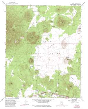
Parks Topo Map Arizona
To zoom in, hover over the map of Parks
USGS Topo Quad 35111c8 - 1:24,000 scale
| Topo Map Name: | Parks |
| USGS Topo Quad ID: | 35111c8 |
| Print Size: | ca. 21 1/4" wide x 27" high |
| Southeast Coordinates: | 35.25° N latitude / 111.875° W longitude |
| Map Center Coordinates: | 35.3125° N latitude / 111.9375° W longitude |
| U.S. State: | AZ |
| Filename: | o35111c8.jpg |
| Download Map JPG Image: | Parks topo map 1:24,000 scale |
| Map Type: | Topographic |
| Topo Series: | 7.5´ |
| Map Scale: | 1:24,000 |
| Source of Map Images: | United States Geological Survey (USGS) |
| Alternate Map Versions: |
Parks AZ 1966, updated 1968 Download PDF Buy paper map Parks AZ 1966, updated 1975 Download PDF Buy paper map Parks AZ 1966, updated 1988 Download PDF Buy paper map Parks AZ 1966, updated 1988 Download PDF Buy paper map Parks AZ 2012 Download PDF Buy paper map Parks AZ 2014 Download PDF Buy paper map |
| FStopo: | US Forest Service topo Parks is available: Download FStopo PDF Download FStopo TIF |
1:24,000 Topo Quads surrounding Parks
> Back to 35111a1 at 1:100,000 scale
> Back to 35110a1 at 1:250,000 scale
> Back to U.S. Topo Maps home
Parks topo map: Gazetteer
Parks: Crossings
Parks Interchange elevation 2165m 7103′Parks: Flats
Beale Flat elevation 2270m 7447′Brannigan Park elevation 2212m 7257′
Government Prairie elevation 2255m 7398′
Rain Tank Flat elevation 2283m 7490′
Parks: Gaps
Sanderson Pass elevation 2279m 7477′Schultz Pass elevation 2362m 7749′
Parks: Parks
C. Hart Merriam Base Camp Site elevation 2242m 7355′Parks: Pillars
Eagle Rock elevation 2469m 8100′Parks: Populated Places
Maine elevation 2161m 7089′Parks elevation 2158m 7080′
Parks: Reservoirs
Autry Tank elevation 2272m 7454′B B Tank elevation 2260m 7414′
Beale Tank elevation 2257m 7404′
Brannigan Tank elevation 2224m 7296′
Curry Tank elevation 2240m 7349′
Dennis Tank elevation 2153m 7063′
Divide Tank elevation 2243m 7358′
Fortynine Tank elevation 2230m 7316′
Government Hole elevation 2253m 7391′
Government Prairie Trick Tank elevation 2296m 7532′
Horseshoe Tank elevation 2297m 7536′
Jacks Tank elevation 2259m 7411′
Jerrys Tank elevation 2226m 7303′
Kaufman Tank elevation 2189m 7181′
Klostermeyer Spring Tank elevation 2264m 7427′
Mineral Tank elevation 2110m 6922′
NE Tank elevation 2177m 7142′
Obsidian Tank elevation 2245m 7365′
Prairie Tank elevation 2255m 7398′
Quakie Tank elevation 2237m 7339′
R S Tank elevation 2236m 7335′
Rocky Tank elevation 2219m 7280′
Saddle Tank elevation 2230m 7316′
Sawmill Tank elevation 2209m 7247′
Sego Tank elevation 2212m 7257′
Seven Anchor Tank elevation 2260m 7414′
Shoot Em Up Dick Tank elevation 2276m 7467′
Soreye Tank elevation 2237m 7339′
Spitz Tank elevation 2144m 7034′
Spring Valley Tank elevation 2276m 7467′
Parks: Ridges
Pine Ridge elevation 2327m 7634′Parks: Springs
Beale Spring elevation 2255m 7398′Hausman Spring elevation 2249m 7378′
Kaufman Spring elevation 2225m 7299′
Klostermeyer Spring elevation 2264m 7427′
Little Spring elevation 2233m 7326′
Lower McDermit Spring elevation 2177m 7142′
McDermit Spring elevation 2201m 7221′
NE Spring elevation 2184m 7165′
Sawmill Spring elevation 2207m 7240′
Spitz Spring elevation 2131m 6991′
Upper McDermit Spring elevation 2208m 7244′
Parks: Summits
Beale Mountain elevation 2355m 7726′Fortynine Hill elevation 2396m 7860′
Government Hill elevation 2566m 8418′
Government Mountain elevation 2539m 8330′
Klostermeyer Hill elevation 2381m 7811′
R S Hill elevation 2455m 8054′
Section Hill elevation 2247m 7372′
Spitz Hill elevation 2350m 7709′
Spring Valley Knolls elevation 2306m 7565′
Wright Hill elevation 2387m 7831′
Parks: Trails
Cross Country Ski Trail elevation 2251m 7385′Parks digital topo map on disk
Buy this Parks topo map showing relief, roads, GPS coordinates and other geographical features, as a high-resolution digital map file on DVD:


