Goldtooth Topo Map Arizona
To zoom in, hover over the map of Goldtooth
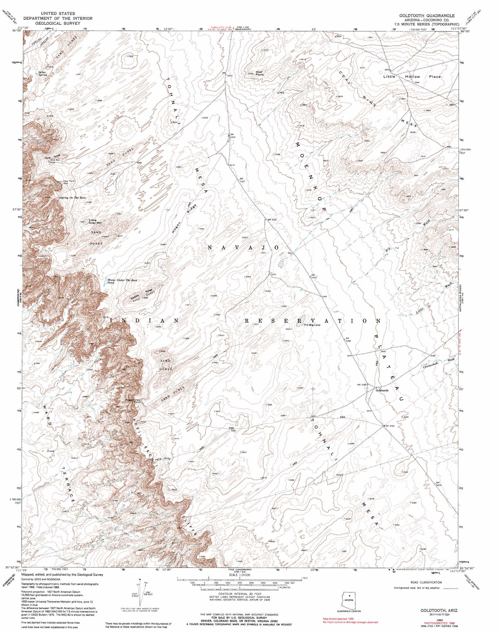
USGS Topo Quad 35111h2 - 1:24,000 scale
| Topo Map Name: | Goldtooth |
| USGS Topo Quad ID: | 35111h2 |
| Print Size: | ca. 21 1/4" wide x 27" high |
| Southeast Coordinates: | 35.875° N latitude / 111.125° W longitude |
| Map Center Coordinates: | 35.9375° N latitude / 111.1875° W longitude |
| U.S. State: | AZ |
| Filename: | o35111h2.jpg |
| Download Map JPG Image: | Goldtooth topo map 1:24,000 scale |
| Map Type: | Topographic |
| Topo Series: | 7.5´ |
| Map Scale: | 1:24,000 |
| Source of Map Images: | United States Geological Survey (USGS) |
| Alternate Map Versions: |
Goldtooth AZ 1969, updated 1972 Download PDF Buy paper map Goldtooth AZ 1969, updated 1991 Download PDF Buy paper map Goldtooth AZ 2011 Download PDF Buy paper map Goldtooth AZ 2014 Download PDF Buy paper map |
1:24,000 Topo Quads surrounding Goldtooth
Willow Springs |
Moenave |
Tuba City |
Middle Mesa |
Begashibito Canyon |
Shadow Mountain Well |
Moenave Se |
Moenkopi |
Tuba City Se |
Bat Canyon |
Cameron North |
Cameron Ne |
Goldtooth |
Appaloosa Ridge |
Coal Mine Mesa |
Cameron South |
Cameron Se |
The Landmark |
Gold Spring |
Dinnebito Spring |
Gray Mountain |
Wupatki Ne |
Badger Spring |
Rock Head |
Sand Springs |
> Back to 35111e1 at 1:100,000 scale
> Back to 35110a1 at 1:250,000 scale
> Back to U.S. Topo Maps home
Goldtooth topo map: Gazetteer
Goldtooth: Basins
Little Hollow Place elevation 1694m 5557′Goldtooth: Cliffs
Hogan View Point elevation 1537m 5042′Wolf Point elevation 1690m 5544′
Goldtooth: Flats
The Big Lake elevation 1628m 5341′Goldtooth: Lakes
Water under the Rock Pond elevation 1625m 5331′Goldtooth: Ridges
Hogan Ridge elevation 1642m 5387′Saddle Ridge elevation 0m 0′
Goldtooth: Springs
Seller Spring elevation 0m 0′Spring on the Rock elevation 1588m 5209′
Goldtooth: Streams
Big Wash elevation 1643m 5390′Chiehazhahi Wash elevation 1659m 5442′
Little Wash elevation 1657m 5436′
Goldtooth: Summits
Little Gray Hill elevation 1653m 5423′Tohnali Mesa elevation 1626m 5334′
Goldtooth: Wells
View Point Well elevation 1596m 5236′Goldtooth digital topo map on disk
Buy this Goldtooth topo map showing relief, roads, GPS coordinates and other geographical features, as a high-resolution digital map file on DVD: